


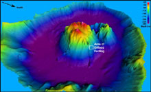
Three-dimensional view of the Maug caldera (2 times vertical exaggeration). EM300 bathymetry data (10 meter grid cell size), ranging in depth from 241 to 25 m (790-82 ft). On this 2004 Submarine Ring of Fire expedition, the Maug survey was completed, providing complete coverage over the shallow central lava dome. Click image for larger view.
Maug Island: Inside the Volcano
April 9, 2004
Bill Chadwick
Geologist
CIMRS Program, Oregon State University
NOAA Vents Program, Pacific Marine Environmental Laboratory
![]() See how the ROPOS ROV is deployed at the Maug Island volcanic crater. (mp4, 4.4 MB)
See how the ROPOS ROV is deployed at the Maug Island volcanic crater. (mp4, 4.4 MB)
Maug Island is an amazing place, both above and below sea level. It is a large volcanic crater, or “caldera,” that is now flooded by the sea. The caldera formed long ago after a massive eruption caused the summit of this volcano to collapse. The three islets that make up Maug are the remnants of the circular crater rim. The inward-facing crater walls (of the islets) are spectacular cross-sections through the volcano, as though a giant had cut a thick layer cake with a knife. In the steep cliffs, innumerable lava flows and ash layers are exposed, as well as their vertical feeders (dikes) that supplied lava from below. The cliffs serve as the nest sites for thousands of seabirds. In a skillful display of ship handling, the R/V Thomas G. Thompson officers maneuvered the ship between two of the islets so that the ROPOS ROV (remotely operated vehicle) could dive inside the crater.
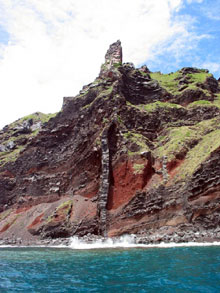
The vertical column in the center of the image, called a dike, rises from below sea level to the pinnacle at the top of the ridge. Interlaid massive lavas (darker horizontal bands) and ash-rich lava units (reddish) are also exposed on the islets of Maug. Click image for larger view and image credit.
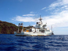
The R/V Thomas G. Thompson holding station over Maug caldera while the crew prepares to deploy ROPOS. The Thompson is 86 m (274 ft) long from bow to stern. Click image for larger view and image credit.

ROPOS is deployed from the “fantail” of the Thompson. Click image for larger view and image credit.
Below sea level, the crater is a bowl-shaped basin that is as much as 250 meters (820 ft) deep. At the center of the crater, a lava dome rises to within 20 m (65 ft) of the surface and represents the most recent output from this volcano. The dome is so shallow, in fact, that when ROPOS traversed to the top during a dive in the middle of the night, we could look over the side of the Thompson and see ROPOS's lights underwater!
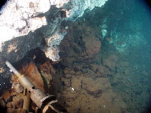
The Hot Fluid Sampler (HFS) was used to sample hydrothermal fluids at Cave vent. The sampling nozzle is 25 cm (10 in) long. The white coating on the rocks is bacterial mat. Click image for larger view and image credit.
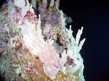
The top of one of the central domes in Maug caldera, covered with several different types of corals, sponges (white encrusting towers) and algae. Notice the beautiful lilac anemone near the top right of the dome. It's nearly 30 cm (12 in) in diameter. Two clown fish are hiding within it. Click image for larger view and image credit.
The goal for our dives at Maug was to find the source of hydrothermal venting that was detected here during our expedition last year. A line of diffuse vents was found on the northeast side of the dome at a depth of about 145 m (475 ft). The hot springs were surrounded by extensive areas of white and yellow bacterial mat. Above 100 m (328 ft) depth, on the sides of the dome, the sea floor gradually transitioned into a coral reef environment inhabited by colorful species of sponges, corals, algae, and fishes, until no trace of the lava dome itself could be detected.
Sign up for the Ocean Explorer E-mail Update List.