


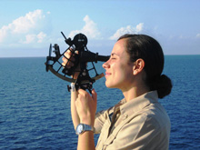
Figure 1. A sextant used for navigation at sea. Click image for larger view and image credit.
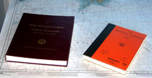
Figure 2. Navigation almanacs used on the NOAA ship Ronald H. Brown. Click image for larger view and image credit.
Navigation at Sea: A Matter of Triangles
Bernie B. Bernard
TDI-Brooks International, Inc
How do you locate, or find your way back to, a particular point of interest over a mile below the sea surface on the bottom of the ocean? For that matter, how do you even know where you are at sea when you can’t see the land?
On land, there are established benchmarks (well-defined points of known location) dotting the landscape all over the world, so surveyors can always “tie-in,” or reconcile, to one or more of these benchmarks in order to ensure the measurement accuracy of their point of interest. An accurate survey is performed, for example, by the buyer of plot of land, to minimize disputes with neighbors about who owns the land near the lot lines, upon whose land the fence is built, exactly how big the lot is, and such.
Land surveyors have long-since used mechanical/optical instruments called transits, which are essentially sight-glasses or telescopes with built-in angle-measuring markings. These tripoded instruments can be positioned and aimed very precisely and repeatably at a distant target. Once a transit is properly setup and aligned, its scaled-markings can be used to accurately determine distance and direction, or range and bearing, to a sighted target by making transit measurements from two perspectives of known distance apart. The method of dual range, or dual bearing, measurement for locating a third point (the point of interest) is known as triangulation; and it is an age-old surveying technique.
Long before people were taking measurements, many terrestrial, aquatic, and airborne animals "made their living" using navigation by triangulation via their senses. It’s also the way our two eyes work with our brain to judge the distance of an object, and how our two ears work with our brain to discern the direction of a sound. If we can’t use one of our pair, we lose our ability to triangulate, which diminishes the accuracy of our resulting interpretation. The reason we can’t tell from which direction a sound is coming while underwater is that the sound speed is too fast for our brain to distinguish the tiny difference in time of arrival at each of our ears. In other words, our mechanism for triangulation is designed for use in air, not underwater. In the same way, there are limits to the accuracy and precision of any survey triangulation.
For centuries, mariners have also used a form of the transit, called a sextant, and a triangulation method using the stars, sun, and moon as benchmarks-of-a-sort, even though these celestial bodies move across the sky. The photo (Figure 1) shows the watch officer on the bridge of our vessel “shooting the sun” to “log a transit fix” at 08:00 hours as still specified in the watch orders for each morning.
Visual triangulation using fixed, land-based benchmarks could also be used near-shore if the locations of two or more objects (such as lighthouses, church steeples, towers, and mountain peaks) were in sight. Because there were no fixed benchmarks visible out in the middle of the oceans, mariners have historically relied on celestial objects for their navigation reference points. Techniques were refined over the ages by the development of celestial almanacs or tables that listed the positions of the sun, the moon, the four visible planets, and various stars with each passing hour and day of each year. The photo (Figure 2) above shows the two almanacs used on the bridge of our vessel for our daily transit fixes.
Of course, making accurate angle measurements from the horizon to an object in the sky while on a rocking boat has always been a challenge for navigators. Even more of a problem for early mariners was their inability to even know the precise time of day. The early clocks did not keep good time at sea, due to the disruptive effect on their pendulums by the rocking of the vessel. This limitation resulted in mariners knowing how far north or south they were (their latitude), but not how far east or west they were (their longitude). In fact, the global quest for a good way to measure longitude at sea spawned contests with cash prizes in Europe that eventually led to the development and refinement of an accurate sea-going clock, or chronometer, in the 18th century.
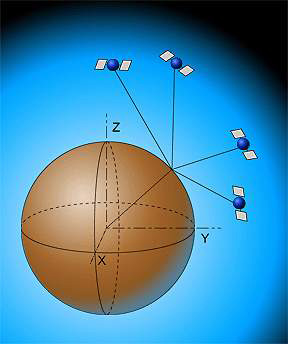
Figure 3. Triangulation using global positioning system (GPS) satellites. Image credit: TELSAT Guide telsat.belspo.be
By the middle of the 20th century, various navigation-signal systems had been developed with stations on shore that allowed mariners to triangulate using radio waves and specially prepared maps of the area on which to plot the position solutions. These systems brought much greater accuracy, perhaps within 15 meters (m), to boat positioning. Today, however, a constellation of satellites has been deployed in space to form a global positioning system (GPS), a system developed by the United States Department of Defense with its first satellite launch in 1978. This navigation system does not require land-based stations for its primary application, so can be used at sea no matter where you are, if you have a GPS signal receiver.
GPS is made up of a network of satellites and their ground stations. The 24 primary and a few back-up satellites circle the earth in orbits 20,000 kilometers (km) up every 12 hours. The satellites act as navigation benchmarks that allow triangulations of position of a GPS receiver that are accurate to within a few meters. Triangulation is made by measuring the travel time of radio signals from the available satellites to the boat’s receiver (Figure 3). Communication with at least three satellites is required for accurate horizontal location, and with at least one more to add vertical location. The more satellites used for triangulations, the more accurate the location, perhaps to 2 or 3 m. The frequency of these signals allows penetration of clouds, fog, and rain, so the mariner can receive accurate data even in foul weather.
Also, one of many land-based GPS support stations around the world can add to accuracy. The method of using a nearby add-on base-station, called differential GPS, compares the GPS-measured location of the base station to the measured location of the GPS receiver on the boat, and then applies its knowledge of exactly where the base station is, to correct small, simultaneous errors in the measured location of the receiver on the boat. This method generates positions accurate to as little as 0.3 m, even far out at sea!
Today, the mariner can know where his boat is, anywhere in the world, to the accuracy needed by virtually any scientific application, but the method of triangulation has been in play from the beginning.