


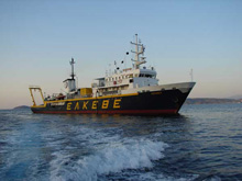
The Greek national research vessel AEGAEO, operated by the Hellenic Centre for Marine Research, will be the support ship for Project PHAEDRA 2006. Click image for larger view and image credit.
Mission Plan
Brendan Foley
Chief Scientist
The scientific goals of the Partnership for Hellenic/American Exploration in the Deep Regions of the Aegean (PHAEDRA) 2006 are three-fold, and fit the general categories of archaeology, earth science, and engineering. For the archaeological component, under the direction of archaeologists from the Hellenic Ministry of Culture’s Ephorate [Department] of Underwater Antiquities (EUA), the team will survey shipwreck sites selected by EUA.
PHAEDRA’s archaeological objectives are to determine the dates of the vessels as closely as possible; the dimensions of the wreck sites; and the nature of their cargoes. Interpretation of these data will help determine the cultural identity of the sailors and the vessels’ possible origins, intermediate port calls, and suspected ultimate destinations. We also will investigate and seek to characterize the environmental and preservative characteristics of the water and sediments around the wreck, and will experiment with new methods for chemical analysis; for instance, regressive carbonate analyses may allow the team to learn information about the nature of original organic cargo elements. We will interpret all of this information within the larger context of the period and cultures in question once those basic questions have been answered. These will be the first surveys of these sites; therefore, we anticipate that many new research questions and opportunities for scholarly inquiry will arise during this expedition.
Archaeology in deep water requires a heavy dose of technology. Reaching the sites will be possible only through the use of underwater vehicles. The systems we will use during this project include the Human Occupied Vehicle (HOV) Thetis, operated by HCMR; and the Autonomous Underwater Vehicle (AUV) SeaBED, from WHOI. Thetis can go as deep as 610 meters, and SeaBED can dive to 2000 m! The experience of investigating a shipwreck via robot or submersible is very different from scuba diving. The scientists can never actually touch the site themselves. All interaction with the site is mediated by the technology. We will ‘see’ the shipwreck only through the AUV’s digital camera images, its multibeam sonar maps, or through Thetis’ acrylic spherical pressure hull. These technologies at once enable us to glimpse into the past, but form barriers between us and the shipwrecks. One area we will explore during the 2006 PHAEDRA project is the cognitive experience of deep water archaeology: how does technology affect the way we understand shipwrecks?
A secondary goal is to develop new techniques and data products for archaeology. The team will deploy a suite of in-situ sensors mounted aboard a precision navigated robotic Autonomous Underwater Vehicle. Many of these sensors have never before been utilized by archaeologists. The AUV’s sensors include a multibeam mapping sonar; high resolution digital cameras for photomosaic and site detail imaging. On board chemical sensors, including the Gemini mass spectrometer, will quantitatively map concentrations of trace chemical components and their isotopes, including dissolved biogeochemical gases (i.e. oxygen, nitrogen, methane, carbon dioxide, hydrogen, hydrogen sulfide, argon) dissolved organic matter, chlorophyll, and petroleum hydrocarbons. Additionally, the team will deploy an experimental 150 kHz subbottom profiling sonar to acoustically image objects under sediments.
In addition to surveying shipwrecks, the team will investigate the Columbo submarine volcano off the island of Santorini. Together with the volcanic fields of Nisyros, Milos, Aegina, the Methana peninsula, and other minor volcanic centers, Columbo is part of the concave Hellenic Volcanic Arc in the southern Aegean Sea. This arc parallels the active front of the Hellenic Orogenic Arc in the Eastern Mediterranean. Columbo’s cone slopes up from the sea floor (400 m) to a depth of 25 m at the shallowest point of the caldera rim. The circular rim of the caldera has a diameter of approximately 2 km and a maximumdepth at the center of 500 meters. The caldera walls are very steep, and are composed of volcanic rocks (i.e. lava flows and pyroclastics).
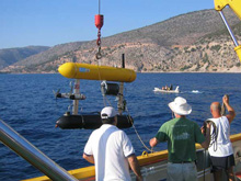
Launching the SeaBED Autonomous Underwater Vehicle during the 2005 Chios Classical Shipwreck Project. Click image for larger view and image credit.
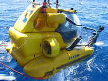
Launching the Thetis Human Occupied Vehicle, operated by the Hellenic Centre for Marine Research Click image for larger view and image credit.
Columbo is an active volcano, notorious for its explosive eruption in September 1650 A.D., which released ash, pumice fall and toxic gases. A strong tsunami, generated by this submarine explosion, propagated in the southern Aegean Sea. The wave devastated the coasts of the surrounding islands and killed fifty people. The 2006 PHAEDRA team will conduct precise bathymetric and chemical mapping of this volcano in order to provide geologists and vulcanologists with a better understanding of its structure and activity.
Data will be collected with the Gemini mass spectrometer mounted on Thetis. Gemini will determine the chemical signature of water seeping from different points on the volcano. These data will be used as baseline measurements for future surveys, and will also provide information about structural and chemical features of the volcano. The data will be compared with other active sites in the Hellenic Volcanic Arc system, and other volcanoes throughout the world.
The investigation of these archaeological remains and geological features can only be accomplished using deep submergence technology. A critically important but easily overlooked aspect of this technology is navigation – the capability of the robots and submersibles to determine where they are on the seafloor. Proper navigation makes possible the documentation and quantification that transforms exploration into scientific inquiry. Because GPS signals are not available underwater, the engineers on the PHAEDRA team will precisely navigate the underwater vehicles by merging information from a mix of sensors: acoustic transponder systems, Doppler Velocity Log, flux gate compass, and ring laser gyro. Combining these sensors’ data allows the team to put into context all of the information gathered by the on-board scientific instruments, and to place those measurements within globally referenced coordinates. This spatially fixed reference will allow scientists revisiting these sites to document changes over time – important for observing archaeological preservation and capturing the slow dynamics of geological processes. To accomplish this, the PHAEDRA engineers will employ new navigation techniques that eliminate much of the cost and complexity of previous methods.
Factors such as weather, sea state, and unforeseen technical difficulties (such as hardware damage, etc.) invariably disrupt any plan. Given the nature of operations in the deep sea, detailed hour-by-hour plans of work are impractical. Therefore, short term operational decisions will evolve as necessary while at sea. The WHOI and Hellenic Centre for Marine Research (HCMR) investigators each have extensive experience with deep sea operations and are well prepared to handle the inherent uncertainties of mission planning for this expedition. Stay tuned and learn what is happening during our mission by checking out our online daily logs!
Sign up for the Ocean Explorer E-mail Update List.