


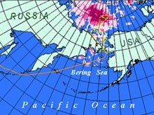
The 2004 RUSALCA cruise is divided into two main "legs." The first leg is shown here in orange, and the second leg is drawn in yellow. Click image for larger view and image credit.
Russian-American Long-term Census of the Arctic (RUSALCA) 2004
Initial Research Cruise to the Bering and Chukchi Seas
July 23 - August 24, 2004
Kathy Crane
U.S. Mission Coordinator
NOAA Arctic Research Office
On July 23, 2004, a Russian research ship, the Professor Khromov, leaves Vladivostok, Russia packed with U.S., Russian, and Canadian scientists. It marks the beginning of a 45-day collaborative journey of exploration and research in the Arctic. It's also an historic day for both Arctic research and exploration as well as Russian-U.S. relations.
Stemming from a 2003 Memorandum of Understanding for World Ocean and Polar Regions Studies between NOAA and the Russian Academy of Sciences, this cruise will be the first activity under the Russian-American Long-term Census of the Arctic (RUSALCA).
This initial cruise is a collaborative U.S.-Russian Federation oceanographic expedition to the Arctic seas regions shared by both countries: the Bering and Chukchi seas. These seas, and the life within, are thought to be particularly sensitive to global climate change, because they are centers where steep thermohaline and nutrient gradients in the ocean coincide with steep thermal gradients in the atmosphere. The Bering Strait acts as the only Pacific gateway into and out of the Arctic Ocean. As such, it is critical to the flux of heat between the Arctic and the rest of the world.
Monitoring the flux of fresh and salt water, as well as establishing benchmark information about the distribution and migration patterns of the sea life, is also critical. We need this information prior to the placement of a climate-monitoring network in this region.

The dynamic nature of the Arctic environment poses a host of intriguing and challenging questions for scientists. Polar researchers are continuously finding new and interesting, sometimes even alarming, information about changes in the sea ice over time. Click image for larger view and image credit.
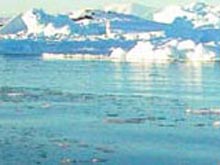
The Arctic Ocean north of Alaska.
The cruise will be divided into two integrated parts, or "legs." Both legs will include sampling and instrument deployment in U.S. and Russian territorial waters. The cruise objectives are to support the U.S. interagency Study of Environmental Arctic Change (SEARCH) Program ![]() and the NOAA Ocean Exploration Program.
and the NOAA Ocean Exploration Program.
LEG 1
Piips Volcano, Bering Sea
Vladivostok, Russia to Nome, Alaska, U.S.
July 23 - August 6, 2004
Kevin R. Wood
NOAA Pacific Marine Environmental Laboratory
Chief Scientist -- U.S.
Vladimir Smolin
The Department
of Defense of the Russian Federation
Chief of Expedition -- Russian Federation
Bordering the Bering Sea at its southern terminus with the Pacific Ocean is the Aleutian Volcanic Arc. Waters entering and exiting the Bering Sea (to and from the Pacific Ocean) transit through this arc. These waters are most likely chemically and dynamically modified by their interaction with the intense hydrothermal activity emitted from the mid-water volcanoes. Quantifying the flux from this relatively shallow volcanic arc, as well as its influence on the waters and atmosphere above, is important, considering the relationship between earth processes -- specifically, ocean and greenhouse gas exchanges.
In the past, Russian Federation scientists have carried out exploration of this region. This cruise, however, marks the first time scientists from both Russia and the U.S. will work together, mapping the volcanic features and searching for fluxes of methane and other hydrothermal fluids and gases.
During the first leg of the RUSALCA Expedition, we will study the hydrothermal activity and related geological and biological processes associated with the Piips Volcano. The volcano lies at a depth of 500 m in the southern part of the Komandorskaya depression of the western Aleutian Arc.
Russian marine geologists discovered the Piips hydrothermal field in 1987. Researchers measured temperatures of up to 130º C, and they discovered hydrothermal deposits comprised of sulfates, carbonates, amorphous silica, etc. In addition, they detected large fields of bacterial mats and numerous hydrothermal fauna.
We still have much to learn about Piips. Very little is known, for instance, about the influence of the area's hydrothermal activity on the regional bio-chemical and physical environment of the neighboring ocean.
LEG 2
Chukchi Sea
Nome to Nome
August 8 - 24, 2004
Dr. Terry Whitledge
University of Alaska
Chief Scientist -- U.S.
Mr. Vladimir Smolin
Ministry of Defense, Russian Federation
Chief of Expedition -- Russian Federation
The second leg of the RUSALCA expedition focuses on ecosystem-oriented exploration. Currently, the Arctic shows a trend in the reduction of ice cover; in the Chukchi Sea study region, there is the possibility of permanent loss in the seasonal ice cover. For these reasons, scientists believe this area might be subject to significant ecosystem change. The RUSALCA studies will provide a foundation for detecting future change in this ecosystem. Nine different scientific programs will examine fish distribution, other water-column and benthic (sea-bottom) biological exploration, nutrient and current fluxes, methane distribution, and sea-floor processes.
In November 2003, a RUSALCA planning workshop in Moscow, Russia outlined the biological, geological, chemical, and physical oceanographic sampling strategies in the Bering Strait and the Chukchi Sea. Participants defined the primary study area as Wrangel Island in Russia to Point Barrow U.S., and north toward the Chukchi Plateau along the Herald Canyon (to the extent that ice conditions permit).
The science team will use high-density conductivity-temperature-density (CTD) stations to examine the role, rates, and rhythms of Pacific water transport through the Herald Canyon. They will also analyze the dispersion of this water into the greater Arctic beyond.
Until recently, the transport pathways of water into and out of this region have been poorly mapped. The degree that these waters mix with newly invasive Atlantic waters over the Chukchi plateau and the Mendeleev and Canada basins is not well known. Understanding these physical and consequent nutrient pathways is critical for mapping the distribution of biota and its migration routes through this Arctic region.