Captain Margaret “Mitzi” Crane. Click image for larger view.
The Atlantis Leaves Dock
July 31, 2004
Jeff Pollack
NOAA
Office of Ocean Exploration
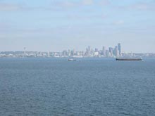
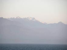
I could tell by the sound of the swells slapping the hull and the increasingly deep roll of the ship that by 3 am we were well outside the J Buoy. The J Buoy -- named for the Morse code “J” signal that it transmits to nearby ships -- marks the dividing line between the semi-sheltered Straights of Juan de Fuca and the open waters of the northeastern Pacific Ocean.
The R/V Atlantis had left the dock at the University of Washington’s Oceanography Building at 2 am on July 30. We had steamed up Lake Union, through a lock and a series of draw-bridges, and into Puget Sound toward the Navy base at Manchester, Washington for refueling. (The fuel stop was arranged months in advance by a government fuel broker so we could avoid market fluctuations). Our nighttime departure was unusual, but the typical daylight departure time had been changed so the Atlantis could arrive at the fuel dock as early as possible. This would minimize the amount of mission time -- or “science time” -- we would lose during the fuel stop.
Captain Margaret “Mitzi” Crane explained that the nighttime navigation had been tricky; the lock and bridges were a tight squeeze for the Atlantis.
According to Captain Crane, the ship had to “tread water" for a hour within a mile of Navy docks as personnel there prepared for our arrival. Finally, the Navy crew was ready for us, but the other large vessels at the dock and the tidal influence made docking a precision operation, even in the morning light. It took over six hrs for the 300-ft Atlantis to top off with around 120,000 gals of fuel -- about half of its capacity -- but by early afternoon we were steaming away toward the J Buoy.