


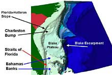
Figure 1. The Charleston Bump is a deep-water, rocky bottom feature on the Blake Plateau southeast of Charleston, South Carolina. Click image for larger view.
Mission Plan: Exploring Habitat and Species Diversity on the Charleston Bump and Blake Plateau
George Sedberry
Steve Stancyk
Principal Investigators
Background
The Charleston Bump was first described in the 1970s, when it was documented that it deflected the Gulf Stream offshore. This deflection and the subsequent downstream eddies, gyres and upwellings help concentrate plankton, fishes and other organisms along thermal fronts downstream from the Bump, and therefore increase overall productivity. In addition to variations in currents around the Charleston Bump, scientists have also noticed wide-ranging and unpredictable variations in bottom temperatures. Swift and ever-changing shifts in currents and temperatures undoubtedly make life for fishes and invertebrates a challenge. Complex bottom features such as caves, however, might provide shelter from the current for many of these species, and such features could harbor a number of new and unique species found nowhere else.
The Charleston Bump is a deep-water, rocky bottom feature on the Blake Plateau southeast of Charleston, SC (Fig. 1). It includes a shoaling ramp and ridge/trough features on which the seafloor rises from 2,100 ft to shallower than 1,200 ft within a relatively short distance, and perpendicular to the Gulf Stream currents. The Charleston Bump includes areas of nearly vertical, 300-ft-high rocky scarps with outcrops and overhangs; other complex bottom, such as coral mounds; and flat hard bottom consisting of phosphorite-manganese pavement (Fig. 2).

Figure 2. Bottom features observed with sonar and submersible (NR-1) on the Charleston Bump. (A) sonar record of steep scarp with caves and overhangs; vertical lines represent 200 m of horizontal distance; horizontal lines represent 12 m of depth. (B) photograph of cave, overhangs and wreckfish associated with scarps such as that depicted in A; (C) coral mounds seen on fathometer trace; (D) manganese-phosphorite pavement (right) and sand (left), with a wreckfish.
A Productive Ecosystem
From the limited information available, it has been discovered that the bottom relief is important to deep-reef fishes and invertebrates. It is also an important area for commercial fishing, including longlining for pelagic species such as swordfish, as well as for fishing the deep reefs and outcrops for species such as wreckfish (Polyprion americanus).
Scientists believe that wreckfish and other large fishes may be abundant on the Blake Plateau in the vicinity of the Charleston Bump because the associated currents help concentrate smaller food sources, such as cephalopods and small fishes. In addition, the feeding behavior of bottom fishes like wreckfish might be important in transferring energy to benthic communities by depositing organic matter (feces) on the bottom. Submersible observations of fish behavior and their habitat preferences can help us determine the sources of energy for productive bottom habitats on the Charleston Bump and surrounding areas of the Blake Plateau. This is particularly important since a substantial number of wreckfish and other fishes that feed in a similar manner are currently being removed by commercial fishing activities, without a full understanding of the effect on species populations and overall community structure.
A Complex Habitat
Most of the existing information on the Charleston Bump and surrounding Blake Plateau has been derived from exploratory trawl surveys that helped describe fish assemblages in very generic and broad terms. The fact remains that it is a very difficult area to visit and explore, given the changing currents and unpredictable sea states that may be encountered. However, the success of past investigations using the Johnson-Sea-Link and other manned and unmanned submersibles indicates an opportunity to continue to learn more about the Charleston Bump and how it functions as habitat. This opportunity should be taken advantage of, given the limited knowledge that currently exists and the continued commercial activities that take place.
In summary, this expedition has been designed to use a manned submersible and associated sampling gear to explore complex habitats on the Charleston Bump, in order make discoveries regarding the diversity of life found there. Discoveries that could prove important to science and natural resource management.
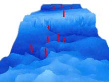
The movie is a simulated flyover of the Charleston Bump, based on sonar data collected there by the NOAA Ship Whiting. The red bars indicating proposed dive sites. The deepest holes at the beginning of the flyover (on the northern part of the Bump) are about 600 m deep. The flight goes over the top of "Wreckfish Scarp" at about 375 m deep, then decends down a "ramp" to a series of ridges at 600-700 m deep. The sideview image is a still image of the bottom topography shown in the flyover movie. (mp4, 1.9 MB)
![]() Click image for video.
Click image for video.
Scientific Objectives
This expedition will focus on describing small habitat features created by the interaction of currents and erosion resistant features. Emphasis will be given to characterizing the faunas associated with steep rocky scarps, scour depressions, and other hard bottom areas. We will make collections of macroinvertebrates to examine assemblages associated with various habitats and with larger sessile (stationary) invertebrates. We will collect deep-water fishes, sponges and corals for analysis of genetic population structure and age structure. Our objectives are to map, explore and describe deep-reef habitats, including characterizing how they are used by marine organisms. We will collect information in order to learn more about the adaptations these organisms have made to live and prosper in these unique and specialized habitats. We will address these objectives by:
1. Mapping habitat features of the Charleston Bump and the adjacent Blake Plateau using fathometer and historical sounding data to direct submersible explorations.
2. Exploring complex habitats such as caves, overhangs, scour depressions, coral mounds, pinnacles, and pavements with a submersible.
3. Visually documenting and describing habitats (bottom features, substrate composition, hydrographic features) and describing assemblages of associated fishes, crustaceans, and large sessile epifauna.
4. Collecting large sessile epifauna to describe assemblages of invertebrates associated with sponges and corals.
5. Collecting (using suction and scoop samplers) macrofauna from microhabitats to compare assemblages for macroinvertebrates from caves, overhangs, scour depressions, pavements, sediments, sponges and corals, and to look for new and unusual species for taxonomic study and educational purposes.
6. Comparing deep-reef faunas associated with different bottom features and hydrographic regimes (e.g., current velocity), in terms of community structure, feeding guilds, and morphological adaptations.
7. Determining, from in-situ observations, densities of fishes in relation to specific habitat characteristics such as substrate orientation and type, sessile benthic fauna and/or associated forage species.
8. Obtaining coral samples for determining growth rates using thin-sectioning and ontogenetic isotopic and trace element analyses, in order to develop growth models that will assist in conservation and restoration of deep-water coral banks.
9. Collecting DNA samples from corals and other organisms to elucidate patterns of recruitment of deep hard-bottom organisms to areas of favorable habitat, such as the Charleston Bump and North Atlantic islands.
10. Deploying "clod cards" to measure small variations in currents found in association with small-scale features.
11. Using conductivity-temperature-depth (CTD) probes and Acoustic Doppler Current Profilers to describe circulation patterns and currents on the Charleston Bump.
12. Developing educational materials from this information.