


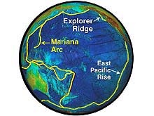
A global view of the Pacific Ring of Fire, showing Mid-Ocean Ridge and Island Arc/Trench Systems. Explorer Ridge and the Mariana Volcanic Arc are shown, as well as the East Pacific Rise. Click image for larger view.
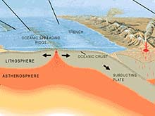
Most submarine volcanoes occur where tectonic plates are either moving apart or colliding. This image shows the many types of plate boundaries. Click image for expanded view, showing island arc system as well as mid-ocean ridge.
Submarine Ring of Fire 2002
Explorer Ridge
June 28 - July 11 and July 23 - August 5, 2002
Part I. Explorer Ridge, NE Pacific
An interdisciplinary exploration team of U.S. and Canadian scientists used new seafloor mapping systems, an autonomous vehicle, and a remotely operated vehicle to investigate the birth of new ocean crust off the coast of western North America, part of the Pacific “Submarine Ring of Fire.” Volcanic ridges lying as close as 60 nautical miles of the northwest U.S. and Canada are part of the world-girdling Mid-Ocean Ridge system, a 60,000 km long series of seafloor spreading centers where new earth is born. The Mid-Ocean Ridge is the beginning of a giant conveyor belt, whereby new ocean floor created at mid-ocean ridges are welded to giant moving plates that are ultimately recycled at island arcs and deep-ocean trenches.
From June to August 2002, the exploration team on board the research vessel Thomas G. Thompson explored the Explorer Ridge, one of the elongate volcanoes of the mid-ocean ridge in the northeastern Pacific where the Pacific Ocean conveyor belt originates.
Background information for this exploration can be found on the left side of the page. Regular updates are included below. Detailed logs and summaries of exploration activities are found on the right.
Updates & Logs
Click images or links below for detailed mission logs and updates.
 Summary Log This exploration has come to a close. Please read the summary log.
 July 31 Discoveries of more vent chimneys, as well as "fossilized" tubeworms, buccionid whelks, and an unidentified purple blue bacterial mat have made this exploration a fascinating experience. The Ring of Fire team has truly discovered a wealth of life in this submarine volcanic wonderland.
 July 29 The science team discovered more than 15 active chimneys, each differing in size, shape, compostion, and inhabitating organisms. They mapped and conducted biological sampling from these various environments.
 July 26 The first ROPOS dive at Explorer Ridge resulted in the discovery of an active hydrothermal chimney, but due to weather conditions, no further investigations could be made. After six months of development, a state-of-the-art digital camera, which was attached to ROPOS, captured striking images of the seafloor, revealing a world of vivid color.
 July 24 This leg is a continuation of another leg that took place between June 28-July 11. After an at sea transfer, some new scientists and equipment have boarded the ship, and are currently enroute to Explorer Ridge, including the remotely operated vehicle named ROPOS. With ROPOS, they will finally see the seafloor in the area where they collected survey data on the previous leg. Read an account by the Teacher at Sea, Kimberly Williams.
 Phase I Summary
June 28 - July 11 In less than two weeks onsite, the Pacific Ring of Fire science party characterized the locations and approximated the extent of hydrothermal activity over Explorer Ridge, employing new surveying technologies, and establishing sites for the remotely operated vehicle ROPOS to explore during the second phase of this mission. Read about the success of the new multibeam sonars and how they aided in mapping the Magic Mountain area.
 July 8 How do you locate a hydrothermal plume in a vast ocean? The task sounds about as easy as finding a needle in a haystack. A variety of sophisticated sensors enable ABE to reveal clues, indicating hydrothermal activity along Explorer Ridge. On July 23rd the science team returned to follow the NEMO expedition
  July 6 What does it feel like to be at sea? Find out as the scientific party maximizes their time at sea, deploying ABE and CTD casts at regular intervals, while simlutaneously interpreting data from these operations.
  July 3 The new multibeam sonar mounted on ABE is completely operational, producing highly detailed bathymetry maps which reveal fracture systems, the ideal sites for hydrothermal activity. Other plumes were found along Explorer Ridge, which may point to a yet to be discovered vent site.
  June 30 After completing two swaths of multibeam bathymetry over Explorer Ridge, the science team started to prepare for further exploration of the ridge. Four transponders were released to triangulate the AUV (Autonomous Underwater Vehicle) ABE, and the now repaired CTD will be deployed tomorrow.
  June 29 En route to Explorer Ridge, the scientists are taking care of last-minute details, while simultaneously getting used to the rolling motion of the ship. Once at Explorer Ridge, a CTD cast will be conducted, which may offer a first look at the hydrothermal systems in this area.
The Ring of Fire Missions
Click images or links below for more information on all Ring of Fire missions.

Take a trip to the seafloor! Explore the hydrothermal vents of the Magic Mountain Chimney Fields via a series of interactive computer animations and videos. (Where is Magic Mountain?)
 Submarine Ring of Fire 2007
(July - August) Scientists return to the Kermadec Arc, to explore in great detail the Brothers submarine volcano. This will mark the most comprehensive exploration of this type of arc volcano and is one of the most vigorous geothermaly active yet discovered.

(April - May) Scientists return to explore active submarine volcanoes lying along the Mariana Arc, extending for more than 800 nautical miles.

(April - May) Join scientist as they explore the active submarine volcanoes along the Kermadec Arc, located north of New Zealand, with a pair of manned submersibles the PISCES IV and V.

(March - April) An interdisciplinary team of scientists returned to the submarine volcanoes of the Mariana Arc to explore, utilizing an underwater tethered robot (ROPOS).

(February - March) An interdisciplinary team of scientists explored the submarine volcanoes of the Mariana Arc lying north of Guam in the western Pacific.

(June - August) An interdisciplinary exploration team used new technology to investigate the birth of new ocean crust off the coast of western North America, part of the Pacific "Ring of Fire."
Sign up for the Ocean Explorer E-mail Update List.