


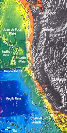
Bathymetric map of U.S. West Coast showing the dramatic tectonic features created by the movement of the Juan de Fuca, Gorda and Pacific Plates. The dashed line shows the 140 meter contour, and indicates the approximate location of the ancient shoreline during the last glacial period (15 - 20,000 years before present). Click image for larger view.
Continuing The Legacy of Lewis And Clark
August 5 - 15, 2002
Almost 200 years ago, Lewis and Clark and the Corps of Discovery made their historic crossing of the United States. This exploration was marked not only by its bold thrust into the unknown, but also by its scientific return. Descriptions of hundreds of plants and animals that were previously unknown to science were a lasting legacy of their expedition. However, one area of the North American continental platform that was inaccessible to early 19th Century explorers was the continental shelf and slope beneath the Pacific Ocean.
In summer2001, a modern-day Corps of Discovery mapped, explored, and documented the physical, chemical, and biological systems of this westernmost portion of the Columbia River drainage system, beginning just 10 miles west of the present mouth of the Columbia River. The 2001 expedition was particularly fitting in light of the upcoming bicentennial of the original one, and because one of Lewis and Clark’s highest priorities was to explore and map the drainage systems of the western United States.
During the low sea level stands of the glacial periods, the Columbia River drained directly into the canyon. After completing the exploration of Astoria Canyon, another exploration phase began when the modern-day Corp of Discovery embarked from Astoria, Oregon, to explore the geology and habitats of invertebrates and commercially important fishes on Heceta Bank, Oregon.
Modern Day Explorers
In the past several years, a team has had several spectacular glimpses of these hidden shores through high-resolution mapping of their outlines from ships and submersible dives that explored their details. Along the Oregon and Southern California margins, modern day explorers have mapped submerged shorelines using swath mapping systems, sidescan sonar, seismic reflection, and submersible and ROV dives. The shorelines themselves are remarkably preserved with many of the features of modern shorelines now residing in 100-200 m (328 - 656 feet) of water. The reconnaissance observations reveal sea stacks, beaches, sea cliffs, lagoons, shore faces, wave cut platforms and sand ripples, all formed 18-20 thousand years ago. These intact features can be explored and mapped, revealing much about climatic geologic and biologic conditions that prevailed at the time.

Map showing Oregon continental margin and three study areas. Click image for larger view.
They can also use the shorelines as indicators of tectonic movement, an important key in the study of earthquakes and submarine landslides. Since they were cut by wave action at roughly mean high tide, they are a valuable marker of sea level 20,000 years ago. Since that time, faulting, folding, and submarine landslides have deformed these formerly horizontal “bathtub rings”, revealing both dramatic and subtle evidence of the tectonics of the last twenty millenniums.
2002 Exploration goals
In order to enhance and optimize the explorations of one of several areas off of Oregon, the team will conduct a high-resolution mapping effort to produce high-resolution bathymetric and backscatter imagery. They anticipate the mapping will cover a bathymetric range from 70 – 700 meters (229 – 2296 feet) and capture the ancient shoreline. They propose to mobilize aboard the R/V Thompson with a hull-mounted state-of-the-art multibeam bathymetry and backscatter system to conduct approximately 10-days of survey work (2 of which will be transit days) off Oregon. The system is a Simrad EM-300 multibeam echoshounder, which is capable of imaging a seafloor swath 4-5 times the water depth (depending on weather conditions) and collecting co-located bathymetry and backscatter data. Resolution at a shoreline depth of 120 meters (394 feet) will be ~ 5 meters (54 feet). These data will be recorded with a digital acquisition system and processed.
Long term objectives
The Ocean Exploration Program offers a new opportunity to “uncover” this hidden part of North America. A program of mapping (current phase) and detailed investigations with an ROV will yield exciting new information about this large area. The team expects to produce the first view of what sections of the glacial coastline looked like in great detail. This will lead to: (1) a new understanding of how early human explorers may have utilized the shoreline in southward migrations as well as (2) a record of the vertical motion of the continental margin over the past 15-20,000 Y.B.P. In addition, these maps will unveil the array of seafloor habitats for modern populations of fish and invertebrates and will likely yield new discoveries of methane seeps and other hitherto undiscovered geologic features.
Sign up for the Ocean Explorer E-mail Update List.