


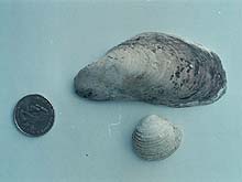
Bivalve samples collected during the 2001 Exploration of Heceta Bank, including a perfectly intact mussel shell recovered from the Bank's ancient shoreline. The mussel shell has been dated to 14 to 15 thousand years before present. Click image for larger view.
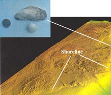
Perspective view of Heceta Bank, "looking" southeast, showing smooth wave cut platforms surrounding the ancient shoreline. Rough area is eroded rock outcrop that was above sea level during the lowstand of sea level. Inset: Mytilus shell, collected at 140 meters during 2001 dive series with ROPOS ROV. Click image for larger view.
Heceta Bank Discoveries in 2001
Visit the 2001 Lewis & Clark exploration offering
Twenty thousand years ago, when the last Pleistocene ice maximum was in full swing, great ice sheets locked up much of the Earth’s water, and sea level was lower by 120-135 meters (394 – 443 feet) than it is today. In most places, the sea was at the outer edge of the continental shelf. The flat continental shelves were carved by the repeated raising and lowering of sea level during the advance and retreat of the ice during the Pleistocene. The changed margins of the continents and the lack of continental shelves had profound effects on ocean circulation, which in turn affected climate. Flora and fauna along these ancient shorelines must also have been quite different, though little is known of these areas because they are hidden deep in the ocean.
During the last year’s Ocean Exploration on Heceta Bank, a number of important discoveries were made. High-resolution multibeam maps made from data collected during an earlier expedition in 1998 revealed the continuity of a late glacial shoreline discovered in the early 1990’s. This shoreline is manifested by a distinct change in backscatter and in many places as a distinct topographic bench. In one place on the northwestern edge of the bank, there is a high-standing outcrop that appears similar to sudden rise the rocky headlands found along the present Oregon coast. Dives with the ROPOS remotely operated vehicle recovered numerous shells in sandy deposits adjacent to this headland.
These samples included an intact mussel-shell valve that has been dated 14-15,000 years before present (BP). The discovery of this ancient shell raises many questions since the water depth here is 140 meters (459 feet), probably deeper than the controversial minus 120-135 meters (394 – 443 feet) being debated by paleooceanographers. The shell is also 40 meters (132 feet) or more below the sea level at 15,000 years B.P. If this date is corroborated by other samples, it implies either problems with the sea-level curves, or that Heceta Bank has subsided more than 20 meters (66 feet) during the past 15,000 years.
The first human explorers to reach North America probably came during the last glacial lowstand, but their migration routes are still problematic. If some of these early migrations were along the coast, we need to look on the continental shelves for evidence. The Heceta Bank data provides the first information on the position and age of the shoreline along the northwest margin of glacial North America which some of these early explorers may have journeyed.
Sign up for the Ocean Explorer E-mail Update List.