This media resources page provides members of the media with information; resources; and broadcast-, print-, and web-quality imagery developed during the Gulf of Mexico 2018 expedition.
From April 11 - May 3, NOAA and partners will conduct an ocean exploration expedition on NOAA Ship Okeanos Explorer to collect critical baseline information about unknown and poorly known deepwater areas in the Gulf of Mexico. The expedition begins in Pascagoula, Mississippi, and ends in Key West, Florida.
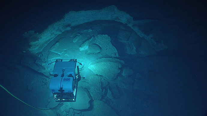
During the cruise, our at-sea and shore-based science teams will work together to map the seafloor and make deepwater scientific observations in exploration areas. Live video of remotely operated vehicle (ROV) dives can be viewed online in real time from April 13 - May 2.
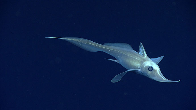
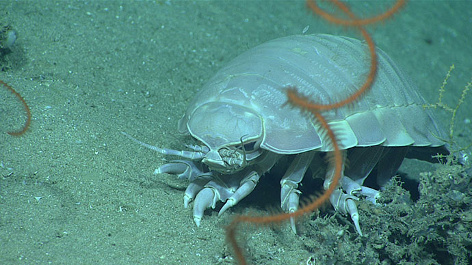
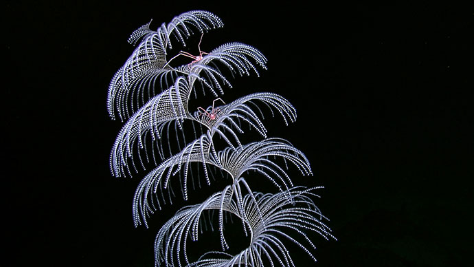
The ship will conduct 24-hour operations consisting of daytime ROV dives and overnight mapping operations, including during transit. Mapping and ROV dives with high-resolution visual surveys and limited sampling activities will focus on priority dive sites and mapping areas in the Gulf of Mexico. Dive sites are expected to include deep-sea coral and sponge habitats, chemosyntheic communities, and potential shipwrecks. This expedition will contribute to foundational information in the region to catalyze further exploration, research, and management activities.
On this page:
Why? | Who? | B-roll/Highlight Videos & Images | Background Info | Contact Info
Despite the Gulf of Mexico’s proximity to land and the significant industrial footprint in the area, there is still much to explore. The Gulf of Mexico contains significant submerged maritime heritage sites that have yet to be explored. Additionally, the Gulf contains a wide range of habitats and interesting geological features ranging from brine pools to coral gardens and canyons to mud volcanoes. The rich and diverse habitats of the Gulf make it an excellent target for interdisciplinary exploration through telepresence due to the broad range of species and habitats for scientists to find. NOAA Ship Okeanos Explorer’s ability to virtually change the expertise of the science party through teleprences makes it an ideal platform for exploring this area.
The Gulf of Mexico 2018 expedition will address science themes and priority areas put forward by scientists and managers from NOAA, management agencies in the region, and the ocean science community. NOAA priorities for the expedition include a combination of science, education, outreach, and open data objectives that will support management decisions at multiple levels:
The expedition involves a number of NOAA partners including the Office of Marine and Aviation Operations; National Marine Fisheries Service’s Office of Habitat Conservation and the Deep Sea Coral and Research and Technology Program; National Ocean Service’s Office of National Marine Sanctuaries and National Centers for Coastal Ocean Science, NESDIS National Centers for Environmental Information; and Office of Oceanic and Atmospheric Research's Office of Ocean Exploration and Research. Other partners include the Gulf of Mexico Fisheries Management Council, Bureau of Ocean Energy Management, and the U.S. Geological Survey.
The individuals listed below will primarily lead activities during the expedition. They will coordinate input from multiple scientists and managers participating from shore to plan dives and are several of the voices you hear on the live video feeds and the primary participants in outreach events. For a full list of our on-ship team, please visit this page.
Dr. Adam Skarke, Co-science Lead
Mississippi State University

Dr. Adam Skarke is an Assistant Professor of Geology at Mississippi State University where he conducts research in the fields of marine geology and geophysics. The goal of his research is to better understand fundamental physical relationships between sediment transport, morphological expression, stratigraphy, and subsurface fluid flow in seafloor environments that span the continental margin from coastal waters to the deep sea. Adam’s recent work has focused on using geophysical mapping tools, such as multibeam sonar, to detect deep-sea methane gas seeps, quantify discharge rates, and characterize associated benthic habitats. He has participated in 24 oceanographic research cruises and utilized human occupied submersibles, remotely operated submersibles, and autonomous underwater vehicles to conduct seafloor and water column exploration. From 2011-2013, Adam was a member of the Okeanos Explorer Mapping Team. In 2016, Adam was named an Early Career Research Fellow by the National Academies of Sciences, Engineering, and Medicine, Gulf Research Program. For additional information please visit: http://www.adamskarke.com .
Dr. Daniel Wagner, Co-science Lead
Southeast Deep Coral Initiative, NOAA National Centers for Coastal Ocean Science

Dr. Daniel Wagner is serving as the expedition's onboard science co-lead and works as the research coordinator for the Southeast Deep Coral Initiative (SEDCI) at JHT Inc./NOAA National Centers of Coastal Ocean Science (NCCOS). Daniel has conducted research on deep-sea corals since 2006, and has participated in over 25 expeditions that have surveyed deepwater ecosystems throughout the Indo-Pacific, Atlantic and Southern Oceans. His research interests include the taxonomy, life history, and ecology of deep-sea corals, particularly black corals. Daniel received his Ph.D. and M.S. in biological oceanography from the University of Hawaii and a B.S. in Biology from Hawaii Pacific University. Daniel is originally from Ecuador, but resides in Charleston, South Carolina.
LT Nick Pawlenko, Expedition Coordinator
NOAA Office of Ocean Exploration and Research

LT Nick Pawlenko joins OER as Expedition Operations Leader. Nick is rotating to land after three field seasons aboard NOAA Ship Okeanos Explorer. During his time aboard the Okeanos Explorer, Nick was able to work with the ROV team, often sitting in as ROV navigator and co-pilot.
Nick graduated from the University of Pittsburgh with a Bachelor of Science in Mechanical Engineering and a Masters in Business. He also recently completed MIT’s Professional Education program Rapid Robotics: Autonomous Systems with Open Source Software.
Prior to joining NOAA, Nick was very involved in the Pittsburgh community and served on the Board of Directors and as Treasurer for the Oakland Business Improvement District for many years. While in Pittsburgh, he also remodeled residential and commercial real estate and was involved in the bar and restaurant business.
Nick is very excited to continue his work with OER and be an asset to the team in his new land assignment.
Michael White, Mapping Lead
NOAA Office of Ocean Exploration and Research

A native of Long Island, New York, Mike took a deep interest in ocean science at a young, age growing up in and on the water. After graduating from the State University of New York Geneseo with a degree in geological sciences, Mike continued his education at the School of Marine and Atmospheric Sciences at Stony Brook University. At Stony Brook, he worked on several projects, including acoustic mapping of coastal areas, coastal sediment management, remote sea level monitoring, submarine groundwater discharge, and applying his GIS proficiencies. Mike’s M.S. thesis focused on the processing of multibeam backscatter and its relationship to the physical characteristics of the seafloor. After completing a graduate certificate in geospatial science and earning a reputation as a reliable field scientist, Mike started a new position as a hydrographic analyst with NOAA’s Sandy Integrated Ocean and Coastal Mapping team at the Center for Coastal and Ocean Mapping (CCOM) at UNH. At CCOM Mike processed outside to NOAA hydrographic datasets, examined additional applications for topobathymetric lidar, collaborated on a seafloor imaging device, and served as a physical scientist supporting hydrographic surveys. As the newest member of the Okeanos Mapping Team, Mike is truly excited to support their mission exploring the oceans. During his off hours, Mike can be found cooking, hiking, or watching movies.
B-roll footage is available here.
Dive highlight videos, short video clips, and photos will be posted online as they are available.
Please see the Contact Us page for information regarding specific media, public, and government inquiries.
Access LIVE video feeds here
Expedition home page
Please see the Contact Us page for information regarding specific media, public, and government inquiries.