


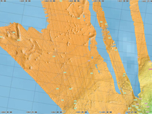
This is a 2003 multibeam bathymetric (water depth) map of the pockmark site. Click image for larger view and image credit.
Heading North
September 18, 2009
Christine Patrick
Public Affairs Specialist
NOAA's Office of Ocean Exploration and Research
On the map of proposed stations for the RUSALCA expedition, six sites sit near 75º and 76º N — far north of the other sites. Even during the Arctic summer, ice usually covers these areas, barring access for anything but an icebreaker. Early this week, though, satellite maps revealed that the ice had been blown far north of the sites, allowing a rare chance to visit them.
The six sites are different from all the others on the proposed RUSALCA stations for at least two reasons: they are in international waters, and they are located above pockmarks, or craters, in the seafloor. These pockmarks were first noticed in 2003 during a multibeam mapping expedition on the U.S. Coast Guard icebreaker Healy. What caused these pockmarks is still unknown, but some scientists speculate they could have been caused by massive releases of methane bursting from the seafloor.
Methane is a potent greenhouse gas that seeps from the seafloor around the world, and is also released from thawing permafrost on land or under the ocean. Little is known about the rate or environmental triggers of methane release. Some scientists hypothesize that massive methane releases many thousands of years ago may have caused a sudden and dramatic warming of the Earth's climate, and therefore emphasize the importance of studying and understanding methane releases.
Near the pockmarks, geologists are also looking for methane hydrates: frozen crystals of water and methane that resemble rocks. Frozen hydrates can occur in conditions where there is a combination of cold temperatures and/or a high-pressure environment. In the Arctic, hydrates are found in the very shallow continental shelves and even on the coastline. The global climate consequences of increased degassing of hydrates in the Arctic are thought to be profound.
Reaching the pockmark sites will likely take two days, and after completing work there, it will take two more days to return to the remaining sites. Adding pressure to the timeline is the possibility that favorable ice conditions at the pockmark sites could disappear in less than a day, if the winds change. But visiting the pockmark areas, so precious to the geologists, sacrifices precious sampling time for the non-geologists aboard. Although the biologists are interested in sampling new sites, many prioritize re-sampling stations that were visited during the few other scientific expeditions to this area, including the 2004 RUSALCA expedition.
At the meeting Chief Scientist Terry Whitledge called for the members of the science teams yesterday, many options were discussed. One option was to head straight for the northern sites, so as not to waste time and endanger the favorable ice-free condition of the area. But many biologists, having caught up on much-needed sleep during the last few days of limited biological sampling in Herald Canyon, were eager to sample sites again and spend the transit working through those samples in their onboard labs.
In the end, a compromise was reached: visit one biological station on the way to the northern sites and one biological station at the first of the six northern sites, and then spend two days doing geological work at the pockmark sites before heading back to the remaining stations in the southern Chukchi Sea.
There is hope and excitement among the science teams that exploring this unknown area will add a new dimension to their work in the Arctic.