


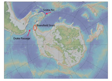
This map of the Antarctic and South America shows the locations of Bransfield Strait, Drake Passage, and Scotia Arc (South Sandwich Islands). Click image for larger view and image credit.
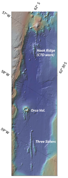
The detailed structure of the sea-floor (shown on this bathymetric map) includes an area within Bransfield Strait. Hook Ridge, Orca Volcano, and Three Sisters are sea-floor spreading centers within the strait, and they have been recently volcanically active. The site where deep-ocean water samples were collected is also labeled. Click image for larger view and image credit.
Sounds of the Southern Ocean 2006
November 20 - December 13, 2006
William Hanshumaker
Hatfield Marine Science Center
Sounds of the Southern Ocean is a joint project to study the dynamic tectonic and volcanic environment of the Bransfield Strait and Drake Passage. The institutions involved in this project are NOAA/Pacific Marine Environmental Laboratory, Oregon State University (OSU), and the Korea Polar Research Institute. This year we completed two main tasks: the recovery and redeployment of a hydrophone array and a remotely operated vehicle (ROV) survey of the floor of the submerged caldera (volcanic depression) of Deception Island. A hydrophone is a device used to detect and/or monitor sounds under water.
We began our mission by boarding a 300-ft Russian icebreaker, the research vessel (R/V) Yuhzmorgeologiya, in Punta Arenas, Chile, on November 19, 2006. Quoting Principal Investigator Dr. Robert Dziak: “It’s an awesome feeling to be crossing waters where some of the most important events in human history have occurred and some of the greatest figures of civilization have traversed. For example, the protected passageway west out of Punta Arenas harbor to the Pacific Ocean is named the Beagle Straits in honor of Charles Darwin’s ship. The passage way east to the Atlantic Ocean is called the Straits of Magellan for the legendary Portuguese discoverer; and, of course, the open water between South America and Antarctica is named after the Sir Francis Drake who first blazed his way through these rough seas in the 1500s.”
Seven hydrophones were deployed last year: one in Drake’s Passage and six in the in the Bransfield Strait between the South Shetland Islands and the Antarctic Peninsula. (We recovered the hydrophone in Drake’s passage on our way to the Korean base on King George Island.) After replacing their hard drives and batteries, five hydrophones were redeployed in the Bransfield Strait. The hard drives contain all of the acoustic data accumulated since last year, and they are currently undergoing analyses at OSU.
After just a few hours of sleep between missions, we roused briefly to experience our closest approach to the mainland of Antarctica. Dozens of icebergs, obscured by low-lying clouds, were revealed by the R/V Yuhzmorgeologiya’s radar. From the deck, we saw the occasional 'berg make a brief appearance, only to be masked by flurries of falling snow.
Deception Island is one of the few active volcanoes breaking the surface of the Southern Ocean. We attempted to locate and sample hydrothermal vents that may be lurking beneath the waters of its caldera, Port Foster. Once again we cast the Niskin bottle rosette (a collection tool) off the stern of the Yuhzmorgeologiya, hoping to capture water samples bearing telltale elements, such as helium and certain metals.
We began our search in a section of Port Foster aptly named Fumarole Bay. From the ship we could see white, wispy vapors rising from fumaroles (surface vents that emit gases) along its shoreline. A full crew loaded into the Korean Zodiac (an inflatable boat) with all of the ROV equipment. We collected 5 hrs of underwater video (at depths of 10 to 100 m) of the diverse macro-floral and faunal life in two selected settings. At Deception Island, we observed enormous populations of amphipods, krill, brittle stars, sea stars and urchins, tunicates, sponges, and sea anemones. At Marion Cove, we also observed krill, sea stars, sponges, and tunicates, but at much lower levels of abundance. We speculate that Deception Island exhibits a much higher level of productivity and diversity of marine organisms because the island forms a protected harbor. This harbor reduces the marine organisms' levels of exposure to strong currents, winds, and seasonal temperature fluctuations.
Accomplished Research Objectives
1) First deep-water hydrophone deployment in Drake Passage and Bransfield Strait, Antarctica;
2) First long-term, microseismic survey of sea-floor tectonic and volcanic activity in Antarctica;
3) First study of a possible link between ice movement and sea-floor tectonic/volcanic activity in the Antarctic;
4) A detailed, deep-water (greater than scuba depth) ROV survey of the marine ecosystem at Deception Island, Antarctica;
5) First acoustic survey of the presence and distribution of large baleen whales (blues and fins) in the Bransfield Strait; and
6) First test of active subduction processes at South Shetland Islands (King George Island), Bransfield Strait.
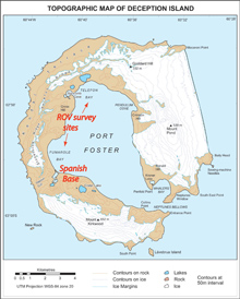
This map of Deception Island — a volcanically active island that last erupted in 1970 — shows the protected harbor-within-the-island, called Port Foster. The locations of the Spanish Base and the remotely operated vehicle surveys conducted within the volcano are also labeled. Click image for larger view and image credit.
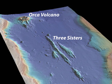
A three-dimensional perspective view of the Bransfield Strait sea floor indicates the locations of Orca Volcano and Three Sisters. Click image for larger view and image credit.
Related Links
The Web links below are provided for informational purposes only. Links outside of Ocean Explorer have been checked at the time of this page's publication, but the linking sites may become outdated or non-operational over time.
Oregon Sea Grant at Oregon State University published detailed reports and pictures on a blog set up for the mission: http://hmscblog.blogspot.com
The daily logs and pictures from our 2005 research voyage to Antarctica can be found at two different sites:
http://seagrant.oregonstate.edu/extension/hanshumaker/ocean_explorations.html
http://oceanexplorer.noaa.gov/explorations/05sounds/welcome.html
Sign up for the Ocean Explorer E-mail Update List.