


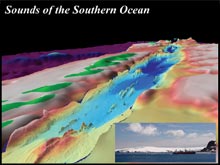
Three-dimensional perspective of the seafloor of the Bransfield Strait, the ocean basin separating the South Shetland Islands (green topography on the left) and the Antarctic Peninsula (green topography on the right). Click image for larger view, more information and image credit.
Sounds of the Southern Ocean
December 3 - December 13, 2005
Robert P. Dziak
NOAA Vents Program
Oregon State University
Hatfield Marine Science Center
![]() View
a virtual fly-through of a three-dimensional perspective of the Bransfield
Strait seafloor. (Quicktime, 2.6 Mb.)
View
a virtual fly-through of a three-dimensional perspective of the Bransfield
Strait seafloor. (Quicktime, 2.6 Mb.)
![]() View
a movie that demonstrates the processes involved in detecting a seafloor
volcanic eruption using a hydrophone. (Quicktime, 440 Kb.)
View
a movie that demonstrates the processes involved in detecting a seafloor
volcanic eruption using a hydrophone. (Quicktime, 440 Kb.)
The Southern Ocean surrounds Antarctica and serves as a conduit between the Atlantic, Pacific and Indian oceans. Yet because of severe climatic conditions, much of this ocean basin remains unexplored. Polar regions play key roles in the global environment and one goal of our project is to document linkages between changes to the Antarctic ice sheet and the volcano-tectonic seafloor processes in the region. To meet the challenge for continuous monitoring in this extreme environment, during December 2005 we will deploy an array of Autonomous Underwater Hydrophones (AUH). This new ocean-sensor technology uses cold-water capable, deep-ocean hydrophones to provide the first-ever comprehensive record from Antarctica of the sounds generated by moving ice sheets, undersea earthquakes and volcanoes; even vocalizations from large baleen whales. When the AUH array is recovered in 2006, sounds that have been captured will enable identification of previously unknown volcanically active regions on the seafloor, as well as the location of critical habitat for the great whales.
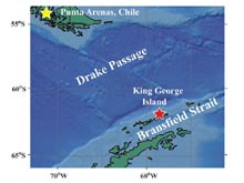
The geographic names of the study area that were the focus of the Sounds of the Southern Ocean expedition. The research group flew via Chilean C-130 from Punta Arenas to King George Island. Click image for larger view, more information and image credit.
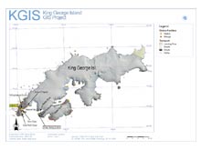
The Sounds of the Southern Ocean expedition will stay at the Korean Antarctic base, King George Island until it is time to board the Russian icebreaker Yuzhmorgeologiya. Click image for larger view, more information and image credit.
Mission Update
We are now back in Chile after a late night C-130 flight from
King George Island. The mission was a great sucess and all seven of our long-term
hydrophones were deployed without a problem. Our Korean colleagues were incredibly
generous both in their hardwork and hospitality while we stayed at the King
Sejong base. The Russian ship Yuzhmorgeologiya proved to be a fine
vessel with which to do our work, and the Captain and crew were exceptionally
dedicated and professional. Unfortunately the food on the ship was too good,
and it will take some time to lose the reminder of how well we were fed!
The weather was also incredibly nice during the deployments, sunny with calm
seas, even in the normally hazardous Drake passage. All of our main mission
goals were completed; we successfully deployed all hydrophones and completed
an extensive visual survey of marine mammals in the region. We look forward
to recovering our deep-sea hydrophone next year and examining the exciting
sounds of the Antarctic they have recorded.
Unfortunately our attempts to get a few, brief real-time hydrophone
recordings four days into the trip were frustrated since the
weather turned and we were unable to use the ship's zodiac in order
to
make a clear recording of natural ocean sounds in the Bransfield
Strait. At one point we even attempted to enter the protected bay of
Deception Island to make recordings, but once again the weather
prevented us from entering the narrow harbor. Such are the difficulties
of working in Antarctica! But we have not yet given up. Dr. Minkyu Park
will try to obtain a real-time recording of ice, marine mammals and
earthquake sounds from the Bransfield Strait when he sets sail on the
Yuzhmorgeologiya again next week. And better still, we hope to enter
the protected waters at the bay in Deception Island during our
expedition next year to get real-time recordings of the active,
high-temperature seafloor hotsprings located in shallow water in
Deception bay.
Related Links
NOAA/PMEL Vents Program and Acoustic Monitoring
Sounds in the ocean file archive
Brief overview of the basic principles of underwater acoustics
Korea Polar Research Institute ![]()
Updates & Logs
Click images or links below for detailed mission logs.
 December 11 The science teams' final destination
was Punta Arenas, Chile, but there were
several challenges.
December 11 The science teams' final destination
was Punta Arenas, Chile, but there were
several challenges.  December 10 Poor weather makes landing on Deception
Island impossible. Learn the importance
of T-waves caused by earthquakes
and volcanic activities.
December 10 Poor weather makes landing on Deception
Island impossible. Learn the importance
of T-waves caused by earthquakes
and volcanic activities.  December 9 The final
hydrophone was deployed in Drake
Passage on level seafloor.
December 9 The final
hydrophone was deployed in Drake
Passage on level seafloor.  December 8 The team continues to actively
deploy hydrophones
on schedule as the nice weather prevails.
December 8 The team continues to actively
deploy hydrophones
on schedule as the nice weather prevails.  December 7 Three of
the seven hydrophones were deployed
during the day thanks to ideal weather and calm seas.
December 7 Three of
the seven hydrophones were deployed
during the day thanks to ideal weather and calm seas.  December 6 The team transfers to the Russian icebreaker
Yuzhmorgeologiya and begins
assembly of the first hydrophone.
December 6 The team transfers to the Russian icebreaker
Yuzhmorgeologiya and begins
assembly of the first hydrophone.  December 5 A steady breeze under 15 knots allowed
a trip to a nearby glacier. Take a journey with them.
December 5 A steady breeze under 15 knots allowed
a trip to a nearby glacier. Take a journey with them.  December 4 The weather cooperated for a hike to the
nearest penguin colony. Read about their
other encounters along the way.
December 4 The weather cooperated for a hike to the
nearest penguin colony. Read about their
other encounters along the way.  December 3 The science party assembled at King Sejong
Station. Read about their journey to this remote Korean base on King
George Island.
December 3 The science party assembled at King Sejong
Station. Read about their journey to this remote Korean base on King
George Island.