


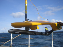
Klein 3000 digital dual frequency side scan sonar used for the mapping surveys. Click image for larger view and image credit.
Habitat Mapping in Olympic Coast National Marine Sanctuary
Steve Intelmann
Olympic Coast National Marine Sanctuary
Understanding the distribution and abundance of seafloor substrates can be useful for supporting management, research, monitoring, and education within the national marine sanctuaries (Barr 2003). It is also useful for addressing concerns ranging from submarine cable engineering projects to cultural resource identification and protection. Seabed characterization was recently described as providing an important contribution to the sustainable management of groundfish fisheries (Kassakian and Ostdahl 2005) and has been integral to the Pacific Coast groundfish management (PFMC 2004) plan for the past several years. With amendment of the Magnuson-Stevens Act of 1996, evaluation and mitigation of the effects of habitat loss or degradation on their specific fishery was mandated, and essential fish habitat (EFH) became a high priority management issue (see related article on ‘What Do Deep Corals Have To Do With Essential Fish Habitat’).
In 2002, Olympic Coast National Marine Sanctuary (OCNMS) chose benthic habitat characterization as a high priority for the site, and has since devoted money and staff effort toward understanding the seafloor environment. Although several sources of historic sediment grab sampling existed within the area (Venkatarathnam and McManus 1973; Nittrouer 1978; Sternberg 1986; Reid et al. 2001), it became evident that medium-scale acoustic geological sampling could better provide an effective means for describing the marine habitat (Greene et al. 1999; Valentine et al. 2003), and that technological innovations such as side scan sonar and multibeam sonar could better assist with delineating ocean-floor substrates (Mitchell and Hughes Clark 1994; Auster et al. 1999; Cochrane and Lafferty 2002; Huvenne et al. 2002; Dartnell and Gardner 2004). Results from annual mapping offer a snapshot of current ground conditions, help guide research and management activities and provide a baseline for assessing the impacts of various threats to important habitat.
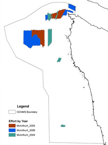
Location and extent of side scan sonar mapping efforts in support of deep-sea coral exploration (2004-2006). Click image for larger view and image credit.
In 2004, 2005, and 2006, side scan sonar was used to map several regions of the seafloor in the northern OCNMS in water depths ranging from 330 to 1,150 feet (Intelmann and Cochrane 2006). The side scan sonarimages provide information about the hardness of the substrate by the reflected acoustic signal received from the seafloor. Objects that appear white in the imagery indicate a hard substrate and dark “shadows” seen near objects provide insight into their size (height above the seafloor) and shape. While side scan sonar does provide a remote impression about the nature of the seafloor, these indications need to be confirmed. Video, photographs or physical samples are used to confirm or refine the interpretation of the side scan data. The two main types of acoustic mapping used by the sanctuary are side scan sonar, to provide an understanding of the substrate type such as sand, gravel, cobble, boulders or bedrock, and multibeam echosounding, which provides information on depth, slope and roughness. The acoustic backscatter from multibeam echosounding can also provide information on substrate type. We also use image textural analysis to automate substrate classification, reducing the subjectivity in the interpretations.
Side scan imagery successfully revealed areas of hard complex rocky seafloor that can provide critical habitat for growth of deep-sea coral and sponge communities. Knowledge of these rocky areas enabled our research team to find and document the presence of coral communities through use of high-resolution videography at 14 of the 15 sites they dove on. The video obtained from a remotely operated vehicle (ROV), bathymetry data, sedimentary grab samples, and the side scan sonar imagery will be integrated to describe the geological and biological aspects of habitat for these areas and polygon features will be created and attributed with a hierarchical deep-water marine benthic classification scheme (Greene et al. 1999). The data can then be used with geographic information system (GIS) software for display, query, and analysis.
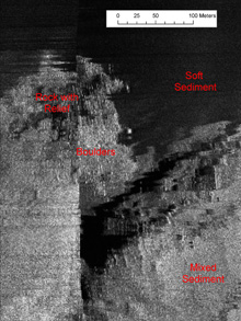
Example of side scan sonar image indicating presence of several substrate types including soft (mud), mixed (gravel, cobble, pebble), boulder field, and high-relief rock outcrop. Click image for larger view and image credit.
As we process the video and still photography, we will be interested to see what percent of glacial erratics had coral or sponge cover versus those without, and whether factors such as station depth, fishing intensity, and site location and bathymetry play a role. Along with our fishery biologist colleagues, we will also be looking at fish densities in relation to substrate habitat. We also will be consulting with marine geologists to find out more about the hard substrate habitats observed, such as a large wall feature about 500 meters long and 100 meters wide, riddled with thousands of burrows and the consolidated sediment benches observed on the canyon walls.
References
Auster, P.J. Michalapoulos, R. Robertson, P.C. Valentine, K. Joy, and V. Cross. 1999. "Use of acoustic methods for classification and monitoring of seafloor habitat complexity." In: Linking Protected Areas With Working Landscapes. Sciense and Management of Protected Areas Association, Wolfsville, Nova Scotia. N.W. Munro and J.H.M. Wilison (eds.) 186-197.
Barr, B. 2003. "US Geological Survey NOAA/National Marine Sanctuary Program’s seabed mapping initiative." 2002-2003 National Marine Sanctuary Annual Report.
Cochrane, G.R., and K.D. Lafferty. 2002. "Use of acoustic classification of sidescan sonar data for mapping benthic habitat in the Northern Channel Islands, California." Continental Shelf Research 22: 683-690.
Dartnell, P., and J.V. Gardner. 2004. "Predicting seafloor facies from multibeam bathymetry and backscatter data." Photogrammetric Engineering & Remote Sensing. 70(9): 1081-1091.
Greene, H.G., M.M. Yoklavich, R.M. Starr, V.M. O’Connell, W.W. Wakefield, D.E. Sullivan, J.E. McRea, Jr., G.M. Cailliet. 1999. "A classification scheme for deep seafloor habitats." Oceanologica Acta. 22(6):663
Huvenne, V.A.I., Ph. Blondel, and J.P. Henriet. 2002. "Textural analyses of sidescan sonar imagery from two mound provinces in the Porcupine Seabight." Marine Geology (189):323-341.
Intelmann, S.S. and G.R. Cochrane. 2006. "Benthic Habitat Mapping in the Olympic Coast National Marine Sanctuary: Classification of side scan sonar data from survey HMPR-108-2002-01: Version I." Marine Sanctuaries Conservation Series MSD-06-01. U.S. Department of Commerce, National Oceanic and Atmospheric Administration, Office of National Marine Sanctuaries, Silver Spring, MD. 13pp. http://www.sanctuaries.noaa.gov/science/conservation/intelmann.html
Kassakian J. and M. Ostdahl. 2005. "Improving the sustainability of fisheries off Washington's outer coast through benthic habitat mapping and characterization." Memorandum to Washington State Policy Working Group. November 3, 2005. Magnuson-Stevens Act, 16 U.S.C. 1801 et seq.
Mitchell, N.C., and J.E. Hughes Clark. 1994. "Classification of seafloor geology using multibeam sonar data from the Scotian shelf." Marine Geology 121: 143-160.
Nittrouer, C.A., 1978. "The process of detrital sediment accumulation in a continental shelf environment: an examination of the Washington shelf." PhD Thesis, University of Washington, Seattle, WA. 243p.
Pacific Fishery Management Council, 2004. Pacific coast groundfish fishery management plan for the California, Oregon, and Washington groundfish fishery as amended through Amendment 17. Pacific Fishery Management Council. Portland, OR. 145 pp.
Reid, J. A., Jenkins, C., Field, M. E., Gardner, J. V. and Box, C. E. 2001. USSEABED: defining the surficial geology of the continental shelf through data integration and fuzzy set theory. Geological Society of America Annual Meeting, Boston, MA. Abstracts with Programs 33:A106.
Sternberg, R.W. 1986. "Transport and accumulation of river-derived sediment on the Washington continental shelf, USA." Journal of the Geological Society of London, v. 143, p. 945-956.
Valentine, P.C., G.R. Cochrane, and K.M. Scanlon. 2003. "Mapping the seabed and habitats in National Marine Sanctuaries." Marine Technology Society. 37(1): 10-17.
Sign up for the Ocean Explorer E-mail Update List.