


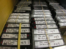
A small fraction of the data being collected on this expedition. Two external cameras and one internal camera are employed during submersible dives, potentially producing six to eight hours of video per dive, all of which has to be organized for later analysis. Click image for larger view and image credit.
Data, Data and More Data
October 23, 2005
Andrea Quattrini
UNC Wilmington, Center for Marine Science
It is 10:00 AM and I am sitting on the bridge of the Seward Johnson as the captain and the submersible crew track the Johnson-Sea-Link (JSL), currently diving nearly 2000 feet below the surface. As I sit here, I log all communications between the JSL and the ship. I periodically log (on datasheets) latitude, longitude, and depth of the sub at various times throughout the dive. This is just one of many activities that occur in my daily life on the ship.
My main responsibility at sea is data management. Basically, it means that I keep track of all data collected at sea. As data are collected, they flow to the central lab, where Missy Partyka, our GIS specialist, and I store, organize, and digitize all data. It may not sound like a full time job, but there is a lot happening during a 24-hour day on the sea. Yes, we collect data 24 hours a day on the Seward Johnson.
Our crew of 15 works 12 plus hours a day, rotating watches to cover the 24-hour period. We all realize the immense opportunity we have, so we maximize our time and collect as much as we can. Everyday, we make two sub dives, during which approximately nine hours of videotapes are recorded. When these come back to the ship, they are copied onto DVDs for archive. Additionally during sub dives, scientists make audio recordings and temperature, depth, salinity, oxygen, pH, and time are recorded from JSL instruments into a file. Locations of the sub throughout the dive are recorded electronically, specimens are collected, and catch logs are created. Art Howard, our expert photographer onboard, photographs numerous specimens (about twenty) every day. When possible, all collected data and multimedia are stored, both on hardcopy and on electronic forms.
During a 24 hour period, we also sample multiple times with several types of gear. During these sampling activities, we record data such as time, date, depth, latitude, longitude, air temperature, surface water temperature, surface salinity, and type of gear onto datasheets. Periodically, we conduct surveys of the bottom using an echosounder, enabling us to determine the depth and profile of the seafloor at specific locations. Depth profiling is important in order to locate dive sites, map new areas that haven't been previously documented, and get a more complete picture of the banks and surrounding areas that we are sampling. Missy and I digitize, electronically organize and store all data, including data collected during submersible dives, by station number; allowing us to locate them quickly and easily.
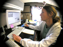
Andrea Quattrini monitors sonar data while the team assesses a potential dive site. Click image for larger view and image credit.
Every minute, continually throughout the cruise, we record the ship's latitude and longitude via a direct GPS feed into a computer program. Also, onboard marine technicians Ilya Nikanorov and Elizabeth Bruce monitor data collected over the whole water column by many instruments: ADCPs, which measure current speeds, CTDs, thermosalinographs, and solar sensors. At the end of the cruise, they provide a copy of these data to the chief scientist.
Just as important as tracking what types of data are being collected is knowing why and how they are collected. It is critical for all future analyses that may be conducted by any scientist (including myself) onboard. In six months from now, without proper data management, one could forget how, why, and what samples were taken, what maps were generated, which specimens were photographed, which videos were recorded, etc. Without proper data management, one can easily misplace or delete a file, a photograph, or a datasheet. I like to think that data management is one of the most important jobs during a research cruise, almost as important as the crew responsible for the submersible. I like to think tracking data is similar to tracking the JSL when it is 2000 feet below the surface. You can't lose it, misplace it, or send it in the wrong direction; and you have to make sure it gets home safely.
Life on the Edge will be sending daily reports from Oct 16 - Nov 4. Please check back frequently for additional logs from this expedition.