


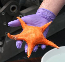
An asteroid sea star, collected while feeding on coral. Click image for larger view.
Return to Bear Seamount
May 11, 2004
Diana Payne
Biologist and Education Coordinator
Connecticut Sea Grant
Mary Grady
Adjunct Earth Science Instructor Northeastern University
A dark illimitable ocean without bound, without dimension, where length, breadth, and height and time and place are lost.
— John Milton, Paradise lost
![]() See bamboo coral being preyed upon by a sea star. (mp4, 1.7 MB)
See bamboo coral being preyed upon by a sea star. (mp4, 1.7 MB)
![]() Watch Chrysogorgia coral being collected by the IFE ROV Hercules on Bear Seamount. (mp4, 1.2 MB)
Watch Chrysogorgia coral being collected by the IFE ROV Hercules on Bear Seamount. (mp4, 1.2 MB)
![]() A beautiful underwater scene of a basalt rocks covered in sea stars, crinoids, brisingid sea stars, sponges, and corals. (mp4, 2.39 MB)
A beautiful underwater scene of a basalt rocks covered in sea stars, crinoids, brisingid sea stars, sponges, and corals. (mp4, 2.39 MB)
![]() Watch a pod of pilot whales as seen from the deck of the Ronald H. Brown. (mp4, 2.62 MB)
Watch a pod of pilot whales as seen from the deck of the Ronald H. Brown. (mp4, 2.62 MB)
![]() View a slide show of images taken May 11.
View a slide show of images taken May 11.
In July 2003, the first Mountains in the Sea expedition dove on Bear Seamount using the DSV Alvin. This year, the return dives use a suite of cameras and
"Predator," the manipulator arm on the remotely operated vehicle (ROV) Hercules. This amazing technology allows several scientists to work side by side, viewing multiple screens (some in high definition) to determine where to sample and what to collect.
The scientists stand watch while the ROV is in the water. Not all the scientists are present at all times, but there is more involvement than with the limited three-person capacity of the DSV Alvin. Dr. Jon Moore and Dr. Peter Auster discussed the differences in viewing video from the ROV and the experience of seeing the landscape in person with a manned submersible. “We’re looking at two-dimensional images with this instead of the three dimensions we get with Alvin,” said Dr. Auster. “Actually being there in Alvin gives you a sense of perspective later, when [you are] viewing the images on the screen.”
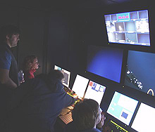
Kari Heinonen, Mike McKee, and Dr. Scott France watch from inside the control van as ROV Hercules' manipulator arm "Predator" takes a sample from Bear Seamount. Click image for larger view.
The day began at about 2 am, with the deployment of Argus and Hercules, and a long descent through the water column to the sea floor at 1600 m depth. The incredible views of the mid-water jellyfish, crustaceans, squids, and deep-sea fishes reminded Dr. Peter Auster of what it must have been like for Dr. William Beebe and Otis Barton back in the 1930s, as they hung from a cable in their bathysphere in the mid-waters off Bermuda. Like Beebe, Auster and graduate student Kari Heinonen began counting fishes and noting their behaviors. So little is known about fishes that live in the most extensive habitat on Earth–the pelagic zone of the ocean—that even primary observations add to the slowly growing body of knowledge.
Once the descent to Bear was complete, observation and sampling began in earnest. By 8 am, images of Bear's basalt slope appeared, dotted with an orange sea spider, sea stars, and brittle stars. Dr. Scott France spotted a coral between two sea stars on the video screen. The scientists requested that the specimen be collected. “I don’t think I brought the tweezers . . . ” said a voice from the control panel.
The art of sample collection is not easily mastered, and collecting Chrysogorgia samples with Predator can be tricky. Twisting, pulling, and turning the manipulator arm with a coral specimen often results in collection of only a small piece of the coral stalk–but the scientists are pleased to have the sample. Some corals are easier to collect than others, depending on their location and flexibility. Despite the twists and turns, this method of collection is far more desirable than dredging or trawling large areas of the sea floor for coral specimens.
Placing collected samples in containers can be just as trying. Conversations between the science party and ROV pilots focus on the possibility of the samples floating away, the size of the specimen, and how to fit it into the available sample containers. A collective sigh of relief echoes through the van as the Chrysogorgia stalk drops into the bio box. Sampling was interrupted by the sudden loss of power from the ROV to the ship.
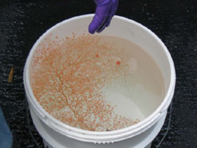
The Chrysogorgia in a bucket of ice water. Click image for larger view.
Right about noon, while many gathered on deck to watch a pod of pilot whales nearby and an occasional shearwater fly past, Hercules was winched back on board. The science team pounced to extract their samples from the bio box. Out came a bamboo coral, a bright orange sea star, a beautiful bright strand of pink-orange Chrysogorgia, a delicate brittle star with its long tentacles tangled around a coral stalk, a shrimp, and a worm.
Each organism was carefully placed into a bucket of cold seawater and taken straight to a walk-in freezer. Samples are then brought into the lab and kept on ice. Doctoral student Anne Simpson snipped off bits for analysis, Dr. Les Watling peered into a microscope, and doctoral student Mercer Brugler carefully dissected a specimen. The take was fairly small, because the dive was aborted early—but it was enough to keep the scientists busy for the rest of the day.
Dr. Watling, scrutinizing the sea star under a microscope, called everyone over to see his find. The magnified image was projected onto a small screen so we all could see it. There were pieces of bamboo coral spicules still in the mouth of the sea star. Apparently it had been captured mid-meal, before it had time to expel the waste. "It's got a mouthful of pooey," Dr. Watling said. "It's as if you put a whole chicken leg into your mouth, and then spit out the bones. This is proof that the sea star was feeding on the deep-water corals. It's the first known predator."
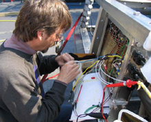
IFE ROV electrical engineer Dave Wright fixes the Argus wiring that malfunctioned. Click image for larger view.
By mid-afteroon, the ROV team had determined the problems with telemetry. It wasn't a cable problem after all, but a short circuit in the Argus wiring. This was good news, because it meant the technicians were able to fix the trouble, with some alcohol, a toothbrush, a bit of electrical tape, and a watercolor brush borrowed from educator Lance Arnold, who is also an artist.
Plasma screens are set up in the main science lab, the coral lab, and the bridge. It’s a great reality show. Crew members not on watch pull up chairs in the science lab. Scientists in the van switch between cameras, sonars, and navigation displays to view the entire landscape. The next ROV dive is scheduled for shortly after dinner. Meanwhile, the crew of the Ronald H. Brown made use of the down time to acquire more SeaBeam bathymetric data. Science party members try to get some work done on their laptops, while catching a glimpse of the action on the screen in the science lab. Some have been up all night, others are catching short naps. Most are running on caffeine and adrenaline, but the return to Bear Seamount and the promise of future dives keeps us going.
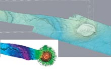
Raw multibeam data for Bear Seamount. Click image for larger view.
Multibeam Comparison
Allan Gontz
Graduate Student
University of Maine
Most recreational boats have fish-finders, which are devices that use sound waves to locate schools of fish and the sea bottom. The NOAA ship Ronald H. Brown has a super fish-finder called a multibeam sonar. Instead of producing a single beam below the vessel, a multibeam system produces 151 beams in a fan-shaped array. This pattern of beams can determine the depth of the sea floor over a swath that is four to five times the water depth. Since the sea floor just west of Bear Seamount is about 2,500 m, we can map a swath about 10,000 to 12,500 m wide in one pass. We use the multibeam system to create maps of the sea floor and locate dive sites or other features of interest. Topography can have a profoundly controlling effect on the ecosystem, providing clues to the geology and evolutionary history of the sea floor.
Unfortunately, the data produced by the system are not without errors. The ship’s motion, bottom topography, and the geometry of the beams interplay to produce various potentially erroneous readings. The data must be "cleaned," or edited by an operator, through a multi-step process. During this cruise, we are using a combination of Mbsytem and FLEDERMAUS to process and visualize the sea floor.
The multi-color image above is a "screen capture" of the raw multibeam data for Bear Seamount. The vessel reached a point over the seamount and held this position for several hours. The result is the feature that looks like a dish or crater on top of the seamount. By processing the raw data and combining this data with data collected during last year’s Mountains in the Sea cruise, we can produce a realistic shaded relief map of the bathymetry of our approach to and the area surrounding Bear Seamount, as shown in the larger image. The darker the blue, the deeper the water.
Sign up for the Ocean Explorer E-mail Update List.