


Ask an Explorer
Questions were sent to the science party during this expedition. Selected questions and answers are offered below.
September 29 - Questions & Answers
September 26 - Questions & Answers
September 29 - Questions & Answers
Questions from: The Bratton Family
Answer by:
John F. Bratton, Ph.D.
U.S. Geological Survey
Woods Hole, Massachusetts
At sea on the R/V Ron Brown
Dear Brattons,
Good to hear from you, and good questions. Here are short answers:
What times of the day do you send the ROV down to collect data? Why do you choose these times?
We send down the ROV as often as we can and for as long as we can. We are doing our 13th dive right now. It will last about six hours. Some of the dives are very short—just a few minutes to test equipment on the ROV. Other dives were ended early because of equipment problems on the ROV (for example, once the lights on the ROV went out as soon as we got to the bottom). Recently, rough seas have postponed dives. We try to balance the number of sites where we dive with the length of time we spend on each dive. Some sites are more than 10 hours apart. When we get to a new site, we start a dive right away, unless we need to spend time mapping the seafloor at the site first. There are two science groups on the ship, and each has a list of dive sites, so we visit sites in an order that makes sense and that divides time fairly between groups. Everyone helps on each dive, but sometimes we work in shifts if the dives go late into the night. So far, our dives have started at 8:23 AM, 2:40 PM, 1:40 AM, 4:50 AM, 5:10 AM, 7:43 AM, 5:00 PM, 7:22 PM, 12:36 AM, 5:46 AM, and 1:55 PM. Some jobs we need to do are directing the ROV pilots and robot arm operators where to go and what to sample, taking notes on what we are seeing on the seafloor, telling the officers on the bridge to reposition the ship so the ROV doesn’t get too far from it (it is attached by a cable), and helping to remove and sort specimens from the ROV’s sample containers between dives.
What kind of species of coral do you think you will find in the Gulf of Mexico?
There are some corals we have found that were expected, since there have been other ROV and submarine dives at some sites, and others that were surprises. We have mostly been able to identify them to the genuslevel, and in some cases to the species (for example, in the name Tyrannosaurus rex the first part is the genus and the second part is the species). At the shallowest sites, there is enough light to support corals that contain algae that help them grow more quickly. A shallow, healthy coral reef may contain over 50 species. The deep sites we are visiting are mostly too dark for corals with algae, so these corals only live by filtering plankton and debris out of the water. The main groups of corals we have seen are hard or stony corals (scleractinians), soft corals or octocorals (mostly gorgonians), and black corals (antipatharians). A fairly common shallow-to-deep hard coral is Madracis (this is a genus; the species is hard to determine until we have a coral expert look at a specimen). The deep hard corals are more rare and we only find a few types, including white bushy Lophelia pertusa and Madrepora. The soft corals and black corals are most common at these sites and include white sea whips (Elisella and Pterogorgia), spiral wire coral (Cirrhipathes, orange or white), bottle-brush black coral (Antipathes), and fan-like gorgonians in many colors (orange, yellow, white, red, or pink). The combination of these corals in strange shapes and colors, and the other weird creatures that live on the dark seafloor sometimes make it look more like the surface of another planet, or a world created by Dr. Seuss, than a part of the ocean just a few hundred feet down.
Write back with more questions and we will try to answer them before our cruise ends on Thursday.
September 26 - Questions & Answers
Questions from: Students at Carmody Memorial Academy (a homeschool)
Answer by:
Doug Weaver
GIS Specialist and Marine Biologist
Flower Garden Banks National Marine Sanctuary
We would like to understand how the transects work. Can you explain that a little more? It was mentioned on September 23, in connection to the first dive. Thank you.
Hello from the NOAA ship RON BROWN! We hope you are all doing well.
To answer your question about transects, we use transects to quantify species abundance in two different ways. First, belt transects are used during SCUBA diver, submarine, or remotely operated vehicle (ROV) surveys to give us estimates of animal densities in their preferred habitats. Belt transects are so named because we have estimates of the length and width of the transect, forming an imaginary belt-like rectangle on the seafloor. I have an example below.
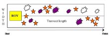
Belt Transects are used during SCUBA diver, submarine, or remotely operated vehicle (ROV) surveys to give us estimates of animal densities in their preferred habitats. Click image for larger view.
Belt Transects- Animal counts and density estimates
In this situation, we might be surveying the ocean floor for sea urchins (purple and white shapes) and sea stars (orange star shapes). We would use lasers on the remotely operated vehicle to estimate the width of the transect (in this case, two meters), and the position of the ROV, estimated by our computer tracking team at the surface. If in this situation we estimated the transect length to be fifty (50) meters, our belt transect would be two by fifty meters (2m X 50m= 100 square meters). If we count sea urchins and sea stars during our belt transect, we can estimate population densities of total number of urchins, purple urchins, white urchins and also sea stars.
If our belt transects are randomly chosen during an ROV dive, we can use these estimates to give an estimate of total number of sea stars and urchins on a deep reef environment, if we have an estimate of both animal density, and an estimate of the area of the deep reef habitat. We can also use this method to compare animal densities among different sites. During our Ocean Exploration expedition with the Innovator ROV we are using these methods to estimate numbers of corals, fish, and large invertebrates (such as crabs, sea stars, urchins, snails) on each of our dive sites.
Mapping Transects
The second type of transect that we are using during our cruise is for multibeam mapping of the seafloor (Gulf of Alaska, July 8 essay by P. Etnoyer). The SEABEAM multibeam echosounder used by the research vessel is a sound-producing instrument aboard the boat that produces a fan-shaped line of sound. These sounds bounce off of the ocean floor, and a computer records the sounds and estimates the water depths below the boat. We are using the multibeam mapping unit to develop more detailed bottom charts to identify new deep coral reefs occurring around the Flower Garden Banks National Marine Sanctuary. We conduct belt transects using the multibeam echosounder by choosing points of interest (waypoints) along a route, and leaving the multibeam computer running as the ship moves from waypoint to waypoint. The computer paints a color-coded map of the seafloor, based on the depths estimated by the computer. Below is an example of what the map looks like on the computer screen:
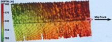
Multibeam echosounder waypoint to waypoint seafloor map. Click image for larger view.
Just yesterday, we used the SEABEAM mapping system to discover a new deep reef that is equal in size to the existing sanctuary, in an area that has never been surveyed before. This discovery has led us to believe that deep reefs are much more common on the outer continental shelf than we had previously thought. Our mapping transects only cover a small fraction of the sea floor, and we will plan to return on future cruises to continue to map this area of the Gulf of Mexico.
Thank you for submitting your question to the ocean exploration team.