


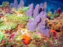
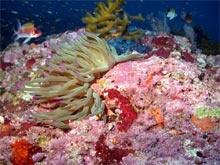
Many of the survey sites are rich palettes of color and texture created by the blend of fishes, sponges, algae, coral and other invertebrates. The level of light available at deeper depths has surprised researchers. This light source allows for the existence of many of these species. Click image for larger view.
Connecting the Dots
Emma Hickerson, Research Coordinator
Flower Garden Banks National Marine Sanctuary
Shelley DuPuy
Flower Garden Banks National Marine Sanctuary
The northwestern Gulf of Mexico is scattered with topographic features in the form of underwater hills or mountains. These features, commonly referred to as banks, bring the ocean floor closer to the surface, providing suitable habitat for a wide array of reef and pelagic fish, algae and invertebrates. Together, they form a system of islands that support higher biological productivity than the surrounding ocean floor. These islands of productivity are connected to each other and to coastal and offshore ecosystems by virtue of the currents flowing through the Gulf of Mexico.
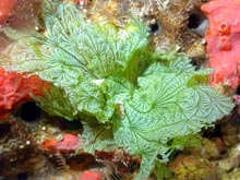
Scientists on this expedition will build on previous explorations by adding to the list of documented animal and plant species. This stunning leafy green algae (Anadyomene lacerata) was documented during a recent submersible expedition. Click image for larger view.
A team of scientists explored a number of these topographic features in the early 1970s. Only a few of the banks (East and West Flower Garden, Stetson, and Sonnier) have been subjected to more extensive study during the ensuing 30 years. These earlier explorations provided a baseline of knowledge against which scientists can compare conditions today and make some general assessments of how things have changed. Little is known about the actual interactions among the various ecosystems supported by this series of topographic features.
The primary goal of the Flower Garden Banks National Marine Sanctuary science team is to revisit many of the banks explored in the 1970s to compare environmental conditions and to use modern technology to characterize their features on a finer scale. By characterizing the ecosystems and comparing them to each other, the team can begin to formulate hypotheses about how these systems are connected, and how impacts to some features can affect the health of others, particularly those within the sanctuary. Knowing where the Flower Garden and Stetson Banks fit in the broader Gulf of Mexico puzzle is vital to making effective management decisions regarding sanctuary resources.
Subterranean Salt Domes
Most of the topographic features being explored on this expedition are sea-floor surface expressions of subterranean salt diapirs (domes). Salt formation began 160-170 million years ago, when salt layers were deposited in what was then a shallow sea, subject to intense evaporation. Sediments were continually deposited over the salt layers. Eventually, internal pressures became great enough to push isolated pockets of the salt layers up through the sediments, forcing the sea floor to bulge upward in distinct domes.
The shallower environments that resulted near the tops of these domes were more conducive to the proliferation of habitats such as hermatypic (hard, reef-building) corals, sponges and algae. These habitats provided shelter and foraging areas for a wide array of other species. In the deeper areas of many banks, erosion has carved out the substrate, forming a honeycomb network of habitat where fish and invertebrates can find shelter. Scientists theorize that currents sweeping into the Gulf from the south carried many of the juvenile species that would ultimately populate the developing habitats.
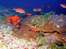
Erosive processes have carved a honeycomb network in the deeper areas of the banks. These formations are generally covered with colorful coralline algae, crinoids (a type of echinoderm, related to sea stars) and gorgonians (a type of coral). Species such as these creolefish (Paranthias furcifer) take advantage of the protective cover such areas provide. Click image for larger view.
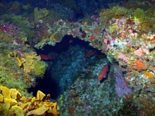
Biological and physical processes have created a multitude of nooks and crannies that provide food and protection for a variety of fish and invertebrates. Click image for larger view.
Vertical Connections
The vertical relief of the banks creates some significant differences in habitats between top and bottom. As the depth of a bank increases, less light penetrates through the water column. The lower light conditions and slightly cooler temperatures at depth attract a different array of species, resulting in habitats with distinctly different characteristics from the shallower areas.
While these differences have been observed and documented, little is known about how the shallower areas relate to the deeper areas. Do predators that frequent the deeper areas depend on the shallower areas for part of their food source? Do currents carry nutrient-rich water up from the deeper areas to help supply food for some of the shallow-water filter feeders? Do species that reside mostly in one depth range go to another depth range to spawn? These are just a few of the questions that remain to be answered.
At the Flower Garden Banks, the giant anemone (Condylactis gigantea) is found only in the deeper areas, not on the reef crest. In other areas of the Caribbean, this species is found in shallow areas. The reason for this difference is unknown. Click image for larger view.
The Land-Ocean Connection
The Gulf of Mexico’s many banks range from just a few miles from the coast to over 100 mi away. It’s easy to see how those close to the coast can be affected by what happens in the coastal areas. Less obvious are the connections that exist between the interior of the United States and the banks farther offshore.
Two-thirds of the continental United States drains into the Gulf of Mexico, much of it through the Mississippi River watershed. Evidence of this connection has been observed as far out as Stetson Bank, located about 70 mi from shore, in the form of freshwater hyacinths. These aquatic plants are normally found in freshwater lakes and rivers, so one can only assume that heavy rains and currents carried them to this location. If freshwater hyacinths can be carried so far offshore, other materials, such as nutrients from fertilizers or oil from leaking transmissions, can also be transported in this way.
Results of the land-ocean connection have already been observed in the area commonly referred to as the "Dead Zone" at the mouth of the Mississippi River. In an attempt to identify some of these impacts on offshore areas, scientists have begun to investigate other, more subtle, signs of possible land-based influences around the banks, such as changes in populations of certain algal species that are indicators of increasing nutrient loads.
This expedition is the continuation of efforts made by explorers who have gone before us. Today’s scientists have the benefit of modern technologies, such as high-resolution multibeam bathymetry and high-resolution digital imaging. It will take many more expeditions to fully comprehend the intricacies of the web binding these features. Such comprehension will greatly enhance the foundation of scientific knowledge upon which resource management decisions are based.