


The ROV being used on the Sanctuary Quest Expedition can record vivid underwater images, like this photograph of krill, during its deepwater dives. Click image for larger view.
Navigating an ROV
May 1, 2002
Ben Waltenberger, Physical Scientist
Channel Islands National Marine Sanctuary
![]() ROV Operator Vince Gerwe describes the advantages of an ROV in a short video clip. (mp4, 2.57 MB).
ROV Operator Vince Gerwe describes the advantages of an ROV in a short video clip. (mp4, 2.57 MB).
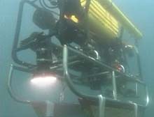
When we deploy a remotely operated vehicle (ROV), we can see what the ROV sees via its onboard cameras. But we also need to know the location of everything we see, as well as keep track of the ROV and its depressor weight to prevent them from banging into rocks or getting tangled in underwater hazards. Tracking the ROV's location requires complex hardware and software, but the honed skills of the ROV navigator are essential as well.
To track the ROV, for this mission the Phantom ROV, the vehicle must report its location to the control van onboard the ship. To accomplish this communication, we use tracking devices called transponders. Transponders are small tubes (3 in by 14 in) containing complex electronics that send and receive acoustic signals to and from a transceiver located in the control van. Each transponder sends an acoustic signal on one unique frequency and receives a signal on another. This allows us to use more than one transponder, each with a unique set of signals. In addition to communicating with transponders, the transceiver in the control van passes on the signals it receives to the navigational software in the control van. For Sanctuary Quest, we are using two tracking transponders. One is mounted on the ROV itself. The other is mounted on the ROV depressor. Both allow us to keep track of these essential parts of the ROV system.
![]() ROV Operator Vince Gerwe describes the advantages of an ROV. Click image to launch video (mp4, 2.57 MB).
ROV Operator Vince Gerwe describes the advantages of an ROV. Click image to launch video (mp4, 2.57 MB).
The navigational software provides visual data to the navigation system. On the navigation screen, we see—scaled to real-world proportions—the ship, the ROV, and the depressor weight. The navigational software integrates information from a global positioning system (GPS) with the transponder information to determine the ROV's latitude and longitude. It also displays seafloor depth, and the depths of the ROV and the depressor weight.
Using these tools, the navigator works with the ROV pilot and ROV deck crew (where the ROV is launched and recovered) to send the ROV where it needs to go and to keep it from damaging itself or the sensitive habitat it is exploring.
Navigation Responsibilities
The navigation station serves a number of functions in a typical ROV mission. Before deployment, the navigator ensures that the tracking equipment is functioning and transponders are set to their proper frequencies. Communications to the bridge of the ship are established so the ship can be provided with course adjustments based on ROV location.
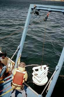
Deployment of ROV depressor weight that is used to stabilize tether during submergence of ROV. (Photo: Robert Schwemmer) Click image for larger view.
During deployment, the navigator monitors the water depth and the depth of the ROV and depressor. The depressor is a large weight located approximately 50 meters up-cable from the ROV. The depressor acts as a “buffer” between the ship and the ROV so that the ROV can swim freely without being “tugged on” by the ship or the rest of deployed cable.
Information on depth is given to the ROV pilot, and instructions on cable length to be deployed are given to the ROV deck. It is very important that depths be monitored so that the ROV initially comes close to the bottom without actually making contact with it. The depressor weight is monitored so that it remains approximately 10 meters off the bottom at all times.
In flat terrain, the navigator has a relatively easy job. In varied terrain, however, navigation becomes much more difficult. The depressor needs to be raised and lowered frequently to keep it from hitting the seafloor and potentially severing the data cable (and thus its only connection to the ship). The ROV pilot must be notified of probable changes in the terrain ahead, and the ship's bridge crew must know of any required course corrections to avoid terrain that might be hazardous to the ROV. In addition, they may be asked to hold steady over areas of interest where scientists may want the ROV to hover.
Sometimes, underwater interference interrupts signals from the transponders, forcing the navigator to “guestimate” the ROV's location. He or she will use information such as water depth, the amount of cabling deployed, and the last known correct transponder data to determine the approximate location of the ROV. Such estimates will keep the ROV out of trouble until real-time transponder pulses resume.

Scientist Ben Waltenberger onboard the McArthur. Click image for larger view.
The bridge crew and ROV pilot have access to a screen similar to the navigator's, but only information relevant to their respective stations is displayed. They may request specific data for their view screens depending on the mission profile. The navigator is responsible for updating their screens with requested information while simultaneously performing all other navigation functions.
The navigation station closely monitors the location of the ROV, its depressor, and the ship during recovery operations. Such close monitoring ensures that cables and equipment surface on the correct side of the ship, and that no equipment surfaces directly underneath the ship.
Once the ROV is safely back on board, the navigator saves the event logs from the mission, which are processed later in a geographic information system (GIS). Historical dive tracks are analyzed, and images taken by the ROV's cameras are matched to known geographic locations.