


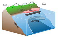
(Figure 1). During upwelling, winds blowing along the coastline from north to south push surface waters offshore. Click image for larger view.
Upwelling
Dr. Steve Gaines
Director, Marine Science Institute &
Professor, Ecology, Evolution, and Marine Biology
University of California, Santa Barbara
Dr. Satie Airame, Science Advisor
Channel Islands National Marine Sanctuary
Winds powerfully affect the oceans and are an important force in creating currents. From global circulation of entire oceans to microscopic patterns of turbulence, winds move water and its resident animals and plants in complex and interesting patterns.
When the wind blows parallel to the coastline, an intriguing and biologically important event occurs. Affected by the rotation of the earth, winds can move water at right angles to the direction the wind is blowing, a phenomenon known as the Coriolis effect. Along a coastline oriented North-South, like much of the west coast of the U.S., winds that blow from the north tend to drive ocean surface currents to the right of the wind direction, thus pushing surface waters offshore. As surface waters are pushed offshore, water is drawn from below to replace them. The upward movement of this deep, colder water is called upwelling.
Effects of Upwelling
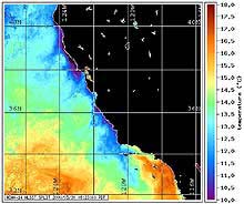
(Figure 2). Satellite image of the temperature of the ocean surface from the spring of 2000. Click image for larger view.
The ecological effects of upwelling are quite diverse, but two impacts are especially noteworthy. First, upwelling brings up cold, nutrient-rich waters to the surface, which encourage seaweed growth and support blooms of phytoplankton. The phytoplankton blooms form the ultimate energy base for large animal populations higher in the food chain, including fish, marine mammals and seabirds. Coastal upwelling ecosystems like the U.S. west coast are some of the most productive ecosystems in the world and support many of the world's most important fisheries. Although coastal upwelling regions account for only one percent of the ocean surface, they contribute roughly 50 percent of the world's fisheries landings.
The second major consequence of upwelling involves its effect on animal movement. Most marine fish and invertebrates produce microscopic larvae as young which drift in the water as they develop. Depending on the species, they may drift in ocean currents for weeks to months. For adult marine creatures that live in shallow waters nearshore, upwelling that moves surface water offshore can potentially move drifting larvae long distances away from their natural habitat, thus reducing their chances for survival. Therefore, upwelling can be a mixed blessing to coastal ecosystems. It can infuse coastal waters with critical nutrients that fuel dramatic productivity, but it can also rob coastal ecosystems of offspring required to replenish coastal populations.
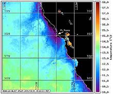
(Figure 3). A closer look at upwelling in the central California region. Note the prominent upwelling center around Pt. Reyes. Click image for larger view.
Though the diagram in Figure 1 implies that upwelling is a consistent process with surface waters moving uniformly offshore, reality is quite different. As scientists collect more detailed data on patterns of circulation in upwelling regions from satellite remote sensing and moored instruments in the water, they have found that upwelling is extremely variable from one place to the next and over time. Although the coastline from Washington to Southern California experiences winds favorable to upwelling, the strength, frequency and dynamics of upwelling vary enormously.
Factors such as variability in the strength and direction of the winds, and the topography of the coastline create an extremely dynamic pattern of upwelling (see Figure 2). In some areas, the cold, upwelled water forms a relatively narrow band near the coastline. Elsewhere, enormous filaments of cold, upwelled water extend hundreds of miles from shore at specific locations, such as Pt. Arena, Pt. Reyes, Pt. A–o Nuevo, and Pt. Sur. Finally, at Pt. Conception, where the coastline abruptly changes direction, upwelling does not occur because the orientation of the coastline and winds are no longer conducive to pushing surface waters offshore.
Upwelling in the Sanctuaries
Upwelling plays an important role for the rich marine resources in each of the five sanctuaries along the west coast. However, the effects on each vary. For example, winds favorable to upwelling tend to be somewhat weaker and more seasonal in the Pacific Northwest than further to the south. Nonetheless, they draw up a rich pool of nutrients that is enhanced by the presence of several deep water canyons nearshore. The resulting food web diversity is spectacular. More species of kelps and marine mammals exist here than anywhere else in the world.
By contrast, one of the strongest regions of upwelling along the California coast is located south and west of Pt. Reyes (see Figure 3). The upwelling filament that extends from the Point bathes Cordell Bank and the Gulf of the Farallones. The resulting nutrient-rich water supports one of the most productive food webs in the marine world. When the winds slow or reverse direction, the upwelling ceases and warm surface waters from the Gulf of the Farallones move back north and toward the coast. These surface waters may transport larval fish and invertebrates to mainland reefs, where they eventually settle and grow.
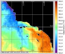
(Figure 4). The abrupt change in coastline orientation at Pt. Conception creates a sharp transition between upwelling regions to the north of the Point and warmer waters of the Santa Barbara Channel. Click image for larger view.
The vast extent of the Monterey Bay Sanctuary, spanning 300 miles of coastline, is characterized by its diversity of oceanographic settings. Upwelling centers located north and south of Monterey Bay (see Figure 3) are the primary source of cool, nutrient-rich water in the sanctuary. No scientific evidence supports the commonly-held belief that the deep Monterey Submarine Canyon contributes to upwelling within the Bay itself. The spatial variability in upwelling and the equally large variation in upwelling intensity over time likely play key roles in the recruitment of fish and invertebrates to coastal reefs.
Finally, the complex geography of Pt. Conception has a profound influence on the oceanographic conditions in the Channel Islands National Marine Sanctuary. The primary direction of the coastline abruptly shifts from north-south to east-west at Pt. Conception (see Figure 4). During the spring and summer months, cool, nutrient-rich waters are upwelled off the coast south of Pt. Conception. These waters are transported to the western islands (San Miguel and Santa Rosa) of the sanctuary where they facilitate high productivity. By contrast, the eastern islands in the sanctuary (Anacapa & Santa Cruz) are bathed by warmer waters, and are associated with subtropical species, which are transported north from Baja California. The sharp boundary between nutrient-rich upwelled waters and nutrient-depleted warmer waters creates a biological transition zone between temperate and subtropical species that is unique to this area.
For more detailed information about research efforts on the connections between upwelling and coastal ecosystems, see the descriptions of ongoing studies in the sanctuaries provided by PISCO ![]() , Plumes and Blooms
, Plumes and Blooms ![]() and the Santa Barbara Coast LTER
and the Santa Barbara Coast LTER ![]() .
.
Sign up for the Ocean Explorer E-mail Update List.