Given that only a small percentage of the ocean has been well explored and that the ocean covers more than 70 percent of our planet’s surface, there’s a lot of undersea territory left for us to explore. Even if we narrow our search to a geographic location, sending divers or robotic vehicles down for a closer look can get expensive. Enter seafloor mapping.
Seafloor mapping is the first step in exploring our ocean. Once scientists or resource managers have identified an area they would like to know more about, ships equipped with technology such as multibeam sonar can collect data used to generate high-resolution bathymetric maps of that part of the seafloor.
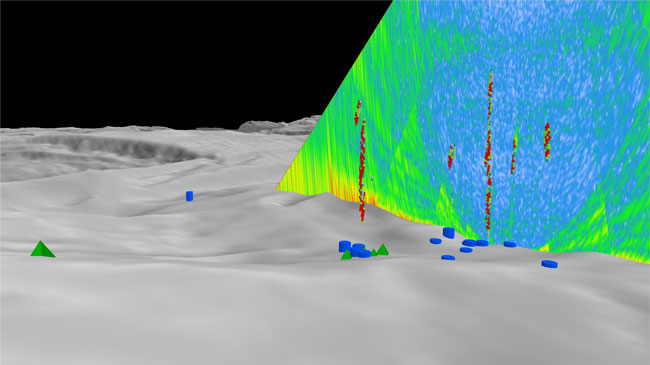
Gaseous seeps in the Gulf of Mexico detected by NOAA Ship Okeanos Explorer's multibeam system. Image created using QPS Fledermaus FMMidwater Automated Target Detection Tool (beta) in collaboration with the University of New Hampshire Center for Coastal and Ocean Mapping / Joint Hydrographic Center.
Using these maps, we can make better decisions about how and where to conduct targeted, more-detailed exploration using tools such as remotely operated vehicles. By keeping us from “flying blind” as we explore, seafloor maps increase the scope, efficiency, and pace of deep-ocean exploration, saving both time and money while increasing our chances for significant discoveries.
In 2012, scientists on NOAA Ship Okeanos Explorer in the Gulf of Mexico used a remotely operated vehicle to find and visually confirm and explore several gas seeps on the seafloor that had been detected by the ship's multibeam sonar earlier that year.