NOAA Ship Okeanos Explorer is the only federal vessel that systematically explores the ocean to collect deep-sea baseline environmental intelligence.
The ship is equipped with a modern, hull-mounted multibeam sonar for generating high-resolution maps of the seafloor to depths of 8,000 meters. Data resolution varies with depth. As the water gets deeper, the footprint of each beam within the sonar swatch gets larger, resulting in decreased resolution. Imagine holding a flashlight close to the ground, then gradually bringing it higher. The footprint of the flashlight beam will get larger with height. The beams of the multibeam act in a similar manner. On the Okeanos, multibeam data is typically collected at a resolution between nine and 50 meters, depending on water depth.
This sonar system is also capable of providing watercolumn and bottom backscatter data. Water column data is a new data type to science and allows us to detect anomalies in the water column such as gas seeps rising from the seafloor. Bottom backscatter data gives us an idea of what the seabed is made of, for example, hard rock or soft mud.
A single beam sonar and sub-bottom profiler round out the ship’s current seafloor imaging capabilities. The single beam provides additional data about the water column, and the subbottom reveals what is below the seabed.
Whether the ship is in transit, conducting remotely operated vehicle operations, or targeting an area for mapping, we are always collecting bathymetric data. In this way, the Okeanos is truly always exploring, increasing the pace and efficiency of discovery and the characterization of unknown ocean areas. Additionally, all mapping (and other) data collected on the Okeanos is made quickly available to scientists, resource managers, and others who can use it to further their research and for other decision-making needs.
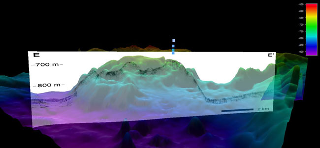
An image of a salt dome in the Gulf of Mexico, with subbottom profiler data shown as black trace, overlain over multibeam bathymetry shown in color. A seep is clearly visible escaping from the seafloor. Data processing performed by NOAA Hollings Scholar Lydia Auner using QPS Fledermaus and SEGYJp2 (software courtesy Geological Survey of Canada).