View captions by moving your mouse over the video for the text drop down. Click on the icon to view the next video in the playlist, and the icon to view the previous video. Click on the icon to see other expedition videos. Click on a video or image in the playlist to download a file or get additional information. Multiple video formats are available on the linked pages for download. You may need to download the Flash browser plugin.
View videos from the NOAA Ship Okeanos Explorer during the INDEX 2010 Exploration of the Sangihe Talaud Region. Known as “America’s ship for ocean exploration”, the Okeanos Explorer, in partnership with NOAA’s Office of Ocean Exploration (OER), will travel around the globe to map and characterize largely unknown areas of the ocean.
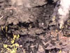
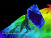
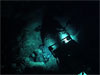
The Okeanos Explorer can discover interesting seafloor features with the deep water multibeam sonar mapping system. In addition, the ship has a dedicated Remotely Operated Vehicle (ROV), which can travel down to a depth of 4,000 meters. Images and high-definition video from the ROV and camera platform will be sent from the vehicles on the seafloor to the ship and to shore in real-time, a technology referred to as “telepresence.”
Although the Okeanos Explorer may be thousands of miles away, the scientists standing watch at shore side exploration "command centers" throughout the country will be able to guide the ship through its mission, and help enable seafloor images and video to stream live into classrooms, newsrooms, and living rooms through high speed internet.
Be sure to click the icon to see other videos and slideshows of various shakedown expeditions from 2008-2010.
Video courtesy of NOAA Okeanos Explorer Program, INDEX-SATAL 2010.


View the Okeanos Explorer Slideshow Collection


INDEX 2010: Google Earth Virtual Tour