

Bathymetry of Subduction
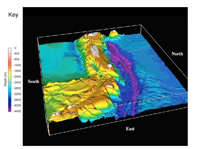
This bathymetric image shows a portion of the seafloor. Study it until you are confident you understand the topography, then answer the questions below.
Questions
- The topography of the seafloor indicates the presence of a convergent plate boundary. Where is the boundary?
[Check Answer]
The boundary runs east-west across the center of the map, between the trench and the island chain:
- Which plate is being subducted? What kind of plate is it, and how can you tell?
[Check Answer]
The plate on the north is being subducted, as shown by the trench on its southern margin. This part of the plate must be oceanic, because it is deep below sea-level and because only oceanic plates can be subducted:
- What is the other, over-riding plate composed of, and how can you tell?
[Check Answer]
The other plate is also an oceanic plate, because a chain of islands has formed on its edge, but sea level drops again away from the boundary:
- How did the island chain form?
[Check Answer]
Magma forms during subduction, when the sinking plate and/or the mantle above it starts to melt. The magma rises up into, and eventually through, the over-riding plate. Lava spills out onto the seafloor, forming a line of undersea volcanoes. The largest volcanoes slowly grow above sea level, into an island chain.
- What benefits do the inhabitants of the islands receive from living on a plate boundary? What hazards do they face?
[Check Answer]
People living on active volcanic islands enjoy dry land, fertile soil, mineral wealth, and scenic beauty. But they are also threatened by violent eruptions, strong earthquakes, landslides, and tsunamis.
Critical Thinking
The bottoms of the trenches formed by subduction are the deepest places on the Earth’s surface dropping several miles below the rest of the seafloor. They are also virtually invisible, hidden from view by the ocean that fills them. Because of their remoteness, trenches have repeatedly been proposed as ideal sites for disposing unwanted material, such as obsolete ships, toxic wastes, and even spent nuclear fuel. Evaluate the use of trenches as dump sites, based on your knowledge of the geology involved. [Possible Answer]
On the positive side, trenches, especially those next to continents, are rapidly filled with sediments, so material dumped in them could be buried quickly and deeply. And some of this debris is carried deep into the earth’s interior with the subducting plate, where it couldn’t harm any living thing.
However, trenches are very active geologically. They experience frequent earthquakes and landslides, and are the point of contact between huge plates as they grind against one another. These forces could breach the containers holding the waste, releasing the material within. Or they could simply crack due to the tremendous water pressure or even just rust from immersion in salt water. Once the waste enters the ocean, currents could sweep it throughout the sea and threaten huge areas with toxic exposure.
Related Links
Multimedia Discovery Missions: Lesson 4 - Subduction Zones