


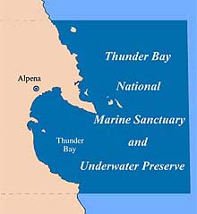
The Thunder Bay National Marine Sanctuary and Underwater Preserve. Click image for larger view.
Project Summary
Surveying "Shipwreck Alley" in Thunder Bay, Lake Huron
June 8 - 22, 2001
Read a brief report from the Chief Scientist, Dwight Coleman.
The Thunder Bay ECHO Expedition used sidescan sonar to survey "Shipwreck Alley" in the deep waters of the Thunder Bay National Marine Sanctuary and Underwater Preserve in Lake Huron. Explorers located and acoustically imaged the deep-water shipwrecks of the Thunder Bay Sanctuary. The project was conducted from June 8-22, 2001, off the northeast coast of Michigan’s lower peninsula.
From wooden sailing ships to early steamers to modern vessels, Thunder Bay has taken many ships to their watery graves. More than 100 shipwrecks, dating back to the 1800s, are suspected to rest in the Sanctuary; however, the locations of only 40 are known. Locating these additional wrecks will further archaeological studies of the Great Lakes' shipwrecks. The collection of shipwrecks in Thunder Bay is an historical archive of commerce in the Great Lakes, and also of the shipbuilding styles characteristic of the last century.
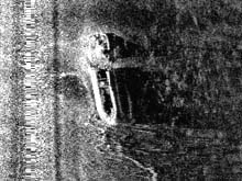
TThe New Orleans was one of ships acoustically imaged during the Thunder Bay ECHO project. Note that the ship is broken in the center. Click image for larger view.
The exploration team ran 24-hr operations while living aboard the U.S. Environmental Protection Agency's research vessel (R/V) Lake Guardian. This 180-ft vessel is outfitted to perform a variety of environmental research tasks. For this expedition, the team used a new sidescan sonar towfish, called ECHO, which uses sound to image objects on the lake floor. Beginning on the lakeward side of the sanctuary, the ship made north-south "tracklines" continually moving west, toward shore. This technique, which researchers call "mowing the lawn," provides systematic coverage of the area under study.
The survey covered about 342 square miles. Within this area, the team located approximately 70 underwater "targets" -- anomalies in the sonar data that could potentially be shipwrecks or other features. Of these targets, 11 were known shipwrecks. The data is currently being processed to determine which of the other targets should be further examined.
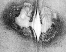
Sonar image of a sinkhole Karst feature, several hundred meters in diameter and approximately 20 m deep. Click image for larger view.
In addition to shipwrecks, dozens of underwater sinkholes were discovered and mapped. The sinkholes represent large collapsed features in the limestone bedrock formations that are prevalent throughout northeastern Lower Michigan. Some of the larger sinkholes were several hundred meters across and 20 meters deep. The underwater sinkholes in Thunder Bay are very significant because they were exposed during the last ice age when the waters of Lake Huron were more than 100 meters below the present day level. Any skeletal remains (human or otherwise), or neolithic stone artifacts in the sinkholes could potentially be well preserved due to the fact that these sites are now below lake level in a non-erosional environment. Further exploration of these sinkholes by a remotely operated vehicle (ROV) could potentially reveal important artifacts.
This is the first phase in mapping and collecting images of the shipwrecks of the Thunder Bay National Marine Sanctuary and Underwater Preserve. Future phases will include completing the sidescan sonar mapping and exploring newly found wrecks with remotely operated vehicles (ROVs). A team will return to Thunder Bay in 2002 with ROVs to explore the wrecks with video imagery and assess their condition for future management and preservation.
Collaborators for the project included the Institute for Exploration, the Thunder Bay National Marine Sanctuary and Underwater Preserve, the State of Michigan, and Benthos, Inc.
Sign up for the Ocean Explorer E-mail Update List.