


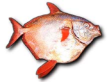
Moonfish (Lampris guttatu), a species about which little is known, is one of the pelagics targeted for the central North Pacific pop-up satellite archival tagging study. Click image for larger view.
Studying Pelagics: Discovering the long distance migration and deep diving behavior for large pelagics in the central North Pacific with pop-up archival transmitting tags
I. Tracking Large Pelagics in the Central North Pacific, November 2002 and February 2003
In early November 2002 and again in February 2003, Don Hawn, a research biologist with the NOAA Fisheries, Honolulu Laboratory, began deploying pop-up archival transmitting (PAT) tags on large pelagic fish from a Hawaii-based commercial longline vessel. Longline vessels fish at depths from 300 – 1,500 ft below the surface and, on a 20-day trip, will typically catch 300 to 500 fish ranging from 80 to 800 lbs. The longliners set their lines deep to target bigeye tunas, but they often catch other fishes including albacore tuna, large sharks (frequently makos and threshers), the colorful moon fish or opah (see figure), and blue and striped marlins.
Don tagged a variety of these pelagic fish with the PAT tags. This fleet of tagged fish carried these tags for preset attachment times ranging from 3 to 6 months. These tags collect data on the depth and water temperature the fish occupies, and use light data to estimate the daily the location of the fish based on day length and time of sunrise and sunset. Once a tag reaches the limits of its attachment time, it will detach from the fish, float to the surface, and transmit its data via satellite to the NOAA Fisheries Honolulu Laboratory. The team believes these data will document a range of behaviors.
Some of these fish may regularly dive to great depth, perhaps below 3,000 ft, while others may rarely go below 300 ft. Likewise, some may travel across the Pacific while others may stay close to Hawaii. These data will help the team describe the different foraging strategies exploited by various top predators. For a case in point, please read the story immediately below.
The Case of the Curious Moonfish Tracks
The moonfish, frequently called opah in Hawaii, is a striking but rather unusual looking fish – round and flat, silver in color with red fins and mouth.
In Hawaii it is caught on tuna longlines set about 1,000 ft below the surface to target bigeye tuna. The opah that are typically landed in the Hawaii fishery weigh about 100 lbs with a diameter of about 3 ft. Because these fish represent a minor part of the fishery landings and dwell in deep oceanic waters, very little is known about their biology and ecology. However, with funding from NOAA’s Office of Ocean Exploration, scientists with the NOAA Fisheries Pacific Islands Fisheries Science Center have been deploying Pop-up Archival Transmitting (PAT) tags on opah caught and released from longlines. The PAT tags stay on the fish for several months then detach, float to the surface, and transmit data on the depth, water temperature, and location occupied by the fish, collected at regular time intervals while the tag was attached. From these data we are gaining new insights into the depths, and water temperatures these opah occupy and their migration routes.
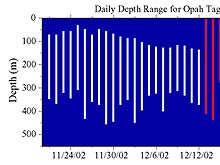
From November 21st, after the fish return to depth with its tag, until December 13th, the opah stayed within the depth range of 50-450m. It never came to the surface during this period. However, beginning December 13th, the daily depth pattern changes dramatically, it reached the surface every day and occasionally made deep dives reaching over 500m. Click image for larger view.
However several of our opah tag data showed very curious patterns. This figure provides the data from tag # 30568 deployed on a 95 lb opah on November 20, 2002, about 200 miles east of Hawaii. From November 21st, after the fish return to depth with its tag, until December 13th, the opah stayed within the depth range of 50-450m. It never came to the surface during this period. However, beginning December 13th, the daily depth pattern changes dramatically, it reached the surface every day and occasionally made deep dives reaching over 500m. This new dive pattern lasted about 10 days. Then, on December 24th, the tag came to the surface and transmitted its data. This was considerably earlier than the programmed release date. If we look at the water temperature data we see something even more curious. During the first period, the opah occupies water ranging from 10o-24o C, but, beginning on December 13th, the water temperature remained relatively constant even though the depth varied from 0 to 400m or more! Further, the temperature reported by the tag was 28 o –30 o C, several degrees higher than the sea surface temperature measured at 26.5 o C both when the tag was deployed and when it transmitted at the surface. The last piece of data in this puzzle was the light sensor measurements. The PAT tag measures relative light levels to estimate the time of sunrise, sunset, and day length all used to estimate longitude and latitude. During the first part of the track the light data ranges from 50 to 150 indicating day and night periods. Again, beginning on December 14th, the pattern changes and the tag only records dark conditions until December 24th.
Our first thought was that the tag malfunctioned beginning December 13 producing erroneous data. However, on further consideration, there was a scenario that explained the data beginning on December 13th. If the tag and perhaps the opah as well were eaten by a predator and the tag remained inside the predator for 10 days, that would explain the dark light level. If the tag was inside the predator, it would still measure pressure and hence depth changes. However, if the predator had a constant elevated body temperature several degrees above the sea surface temperature, then the tag would record only the predator’s stomach and intestine temperature. And finally, the dive pattern would be different beginning December 13th since it was now that of the predator. The first predator that came to mind, given the excursions to the surface, was a large cetacean. Marine mammals do have elevated body temperatures, but they are well above 30 o C too high to match our tag data. However, there are some endothermic sharks, including mako and great white sharks,with elevated body temperatures consistent with those recorded by our tag. Further, mako and white sharks do occur in the oceanic waters around Hawaii. Whether the shark bit off only the tag, attached externally, or consumed both the tag and the opah we don’t know. But now(!), we do know the PAT tag can survive 10 days inside a large predator and still transmits its data.
II. Tracking the Whale Sharks of Ningaloo Reef
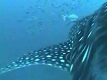
![]() This video, provided by National Geographic, shows a community of fish traveling with the shark. It was taken from a camera attached to the back of a whale shark. On a number of occasions, we noticed that the whale shark was accompanied by an entourage of smaller fishes. Perhaps they viewed the big shark as a moving island in the featureless ocean. Click image for video. (Quicktime, 700 Kb)
This video, provided by National Geographic, shows a community of fish traveling with the shark. It was taken from a camera attached to the back of a whale shark. On a number of occasions, we noticed that the whale shark was accompanied by an entourage of smaller fishes. Perhaps they viewed the big shark as a moving island in the featureless ocean. Click image for video. (Quicktime, 700 Kb)
In May 2003, a team of U.S. and Australian scientists assembled at the remote Ningaloo Reef in Western Australia to study the diving and migration patterns of the magnificent whale shark.
Whale sharks are the world’s largest fish. Adults often reach 12m in length, a ton in weight with a mouth over a meter wide. They take 30 years to reach sexual maturity and may live 100 years. They have thousands of tiny teeth arranged in more than 300 rows but primarily feed on planktonic organisms that they strain from the water as they swim along with their giant mouth agape. Whale sharks have been reported throughout the world’s tropical and subtropical waters. However, apart from occasional sightings, very little is known about their migration and diving patterns. For example, do they persist in one area or follow a migration route through the world’s oceans timed to track seasonal food abundances?
To begin researching this and other questions, we went to Ningaloo Reef. Ningaloo was selected because, during mid-March to mid-May, it is one of the most reliable places in the world to find whale sharks in any numbers. Ningaloo Reef is a 260 km long coral reef and marine park in the eastern Indian Ocean just off Australia’s remote west coast, about 1,200 km north of Perth.
The research team consisted of Mark Meekan with Australia Institute of Marine Science (AIMS), Jeffrey Polovina from the US National Oceanic and Atmospheric Administration (NOAA), Brent Stewart from Hubbs Sea World, and Steve Wilson with the New England Aquarium. The team’s objective was to evaluate whether a relatively new electronic tag known as the pop-up archival transmitting (PAT) tag could be used to study whale shark movements. The PAT tag is attached to the shark externally, and, at the beginning of every hour, it collects data on the depth and temperature the animal occupies. Further, the tag collects light data to estimate the animal’s position by using the light data to calculate longitude from the day length and latitude from the time of sunrise and sunset. After a preset time period, the tag detaches, floats to the surface, and transmits these data via satellite to a computer back in the U.S.
At Ningaloo, we operated out of a small boat, using a spotter plane to locate whale sharks swimming on the surface. Once the spotter found a shark, he would radio the boat, and we would race to the location. With the shark in sight from the boat, we’d jump into the water with mask and snorkel ahead of the direction the shark was swimming. The water was generally extremely clear so the shark could be seen off in the distance heading toward us. The shark showed little concern for us tiny humans and often passed within feet of us. It was truly an awesome experience to lie motionless in the water watching this gentle giant with its big powerful tail slowly sweeping back and forth, swim right at us, mouth open growing larger and larger. For a moment, the panicked thought arises that we might be engulfed by that giant open mouth, but quickly the shark is along side, feet from us. We’re mesmerized, watching the beautiful mottled color pattern on its skin as it glides past. As it passes, one snorkeller sticks a small metal anchor into the shark’s flesh near the dorsal fin. The PAT tag is attached with 6 inches of monofilament line to the anchor.
In our pilot project we attached PAT tags to 5 sharks, and optimistically set the tags to pop off after 8 months. Much to our disappointment for 3 of the 5 tags, the anchors pulled out of the shark in less than 2 weeks after deployment. However the two remaining tag were seen still attached the sharks over a month after their deployments so we have high hopes for some long term tracks.
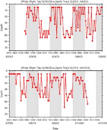
Data from one of the 10-day deployments provides exciting new insights on the shark’s vertical movement. Click image for larger view.
Each attachment was a little different both in the placement location and type of anchor so we’ve learned from these results and have ideas about how to improve future attachments. Even the data from one of our 10-day deployments provides exciting new insights on the shark’s vertical movement. The depth the shark occupied at the beginning of each hour shows the shark is frequently at 50-60m below the surface during most days and close to the surface at night. This was unexpected since it is during the day that we see the sharks at the surface.
These data suggest whale sharks don’t spend a lot of time near the surface during the day and hence the sharks we can see at the surface at Ningaloo Reef are a small percentage of the sharks present. This is good news and important to know when interpreting aerial censuses. Many visual predators forage deep during the day and forage shallow at night to take advantage of the daylight at depth. It appears that whale sharks at Ningaloo Reef are following this pattern. None of the 3 sharks we tagged moved from Ningaloo Reef during the relatively short period of tag deployment. We are looking forward to the data from the remaining tag and have plans to return to Ningaloo in 2004 to deploy more tags, to build upon the lessons we’ve learned from this pilot project.
Sign up for the Ocean Explorer E-mail Update List.