By Scott White, Associate Professor - University of South Carolina,
Bob Embley, Geophysicist - NOAA Pacific Marine Environmental Laboratory,
and Ed Baker, Supervisory Oceanographer - NOAA Pacific Marine Environmental Laboratory
The Galápagos region is a classic site for combined geological and biological investigations going back to the time of Darwin, who developed the Theory of Evolution, as well as an early version of the Theory of Island Development, based partly on observations in the Galápagos. More recently, the first ridge-crest hydrothermal vents were found here in 1977. This discovery revolutionized deep-sea biology, explained previously unexplained characteristics of ocean chemistry, and solved a major problem in solid earth geophysics dealing with heat loss across a seafloor-spreading center. Not until 2006, however, on a research cruise partly sponsored by NOAA, were high-temperature “black smoker” hydrothermal vents finally found on the Galápagos Rift.

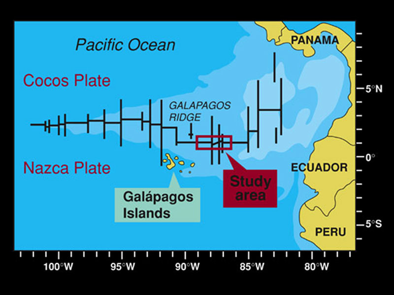
Figure 1: Plate tectonic boundary map of Galápagos region. Galápagos islands are to the south of the spreading ridge. Primary study area is to the northeast of the islands in the area outlined by the box. Area of maximum plume feeding to the ridge is just to the north of the islands. Image courtesy of NOAA Office of Ocean Exploration and Research. Download image (jpg, 836 KB).
What makes the Galápagos region special is the interaction of two powerful forces that shape our planet’s terrestrial and submarine surface, impact ocean chemistry, and form rare and isolated habitats. These two key geologic forces interacting in the Galápagos region are hotspot volcanism and seafloor spreading. Because many of the products of this interaction are manifested only underwater, our understanding and appreciation of them has developed only with modern marine geologic investigations.
The geological origin of the Galápagos region can be traced back at least 70 million years to the initiation of the hotspot volcanism that now produces the Galápagos Islands. Eruptions on the islands of Isabela and Fernandina in the past few years are surface manifestations of the hotspot. This volcanism can be traced backward in time along the Cocos and Carnegie Ridges. This double trace of the hotspot is the result of an interaction of the hotspot with a seafloor spreading ridge. At present, two of the great tectonic plates that comprise the Earth’s surface are moving away from each other just north of the Galápagos Islands. This movement produces the Galápagos Rift, which is the direct subject of the investigation on this mission.
The juxtaposition of the hotspot and the rift affects the construction of the local ocean crust (the primarily igneous layer underlying the ocean basins) in profound ways. Ocean crust at the Galápagos Rift can reach up to one-and-a-half times the thickness of ordinary ocean crust, reaching a maximum thickness near 91°W. The ocean crust diminishes gradually to its normal ~5.5 km thickness to the east and west over 300-400 km along the ridge. The excess thickness near 91°W is associated with anomalies in the composition of the seafloor lava thought to come from mantle material leaking into the ridge system from the adjacent hotspot. Excess magma feeding the Galápagos Rift has built the large volcanic ridge that tapers and deepens away from the hotspot center at 91°W.

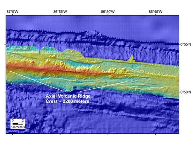
Figure 2: Multibeam bathymetry of the spreading axis of the Galápagos rift in the area of investigations on Leg 2. Hotter colors (red) are shallower depth, and the map is shaded relief illuminated from the north to better show the seafloor shape. This swath was mapped during Leg 1 of this expedition. Most volcanic activity occurs along the crest of this ridge. This area is relatively near the center of hotspot influence, and going farther from the hotspot this ridge would turn into a valley marking the axis of spreading. Image courtesy of NOAA Office of Ocean Exploration and Research. Download image (jpg, 101 KB).
Upon this ridge are many small volcanic seamounts and a fault-bounded linear valley called a “graben”. Both the abundance of the seamounts and the width of the trough decrease systematically approaching the center of hotspot influence along the ridge. The character of volcanic eruptions at the ridge crest also changes as a function of distance from the hotspot. Smaller but more frequent eruptions that produce thinner and broader flows become more common as the hotspot is approached, making it more difficult to build seamounts. This eruption style may be changing the bulk physical properties of the upper crust, such as porosity and permeability, in a significant way. Because the upper crust is critical to hydrothermal fluid flow and seafloor habitats, understanding this change has far-reaching implications.
Each of these lines of geological evidence point to direct feeding of the Galápagos Rift by the adjacent hotspot. The magma provided by the hotspot is supplied independent of melting created by spreading, while the spreading rate remains nearly constant. This sets up a natural controlled experiment. The Galápagos Rift is an excellent lab for understanding how magma supply controls seafloor-spreading processes.
Given this boost in magma supply to the Galápagos Rift, it is curious that the amount of hydrothermal cooling by focused high-temperature vents is lower than expected compared to other ridges of similar spreading rate. The Galápagos Rift must find a way to lose all of the heat from the excess magma supply, and this heat typically drives seafloor ecosystems and affects rock alteration. Scarce venting could result from permeability insufficient to allow large-scale fluid circulation, from large temporal variability in hydrothermal cooling perhaps driven by pulses in volcanism, or from widespread (including off-axis) low-temperature fluid flow that remains undetected. We hope that by exploring the vent sites, and discovering new venting, we will better understand what controls hydrothermal flow here—and globally—along seafloor spreading ridges.