Soundings, Sea-Bottom, and Geophysics
These quotes address the slow and sometimes frustrating process of how humankind has learned about the basins, the seamounts, the fracture zones, the trenches, and the great globe-girdling rift system that make up the floor of the sea.
1725
Myth and the Sea
"The fishermen working on that slope where they are in the habit of finding coral at 150 and 200 fathoms, and their lines not allowing soundings in greater depths, imagine that the bottom cannot be found, and call it in their exaggerated jargon a bottomless abyss, impossible to be sounded. This idea entertained by people of experience in marine matters, as well as by the simple fishers, appears to be absurd, and founded merely on the fact that nobody has yet cared to undertake the trouble and expense required for such soundings, which according to all appearances will never be made unless some Prince orders for that purpose special vessels with suitable instruments.”
In Histoire Physique de la Mer (1725) by Count Luigi Marsigli. Published by Doubleday & Company, Inc. Garden City, New York. p. 177.
1782
Benjamin Franklin Pre-supposes the Theory of Plate Tectonics
"Such changes in the superficial parts of the globe seemed to me unlikely to happen if the earth were solid to the centre. I therefore imagined that the internal parts might be a fluid more dense, and of a greater specific gravity, than any of the solids we are acquainted with; which therefore might swim in or upon that fluid. Thus the surface of the globe would be a shell, capable of being broken and disordered by the violent movements of the fluid on which it rested .... You see, I have given a loose to imagination; but I approve much more your method of philosophizing, which proceeds upon actual observations, makes a collection of facts, and concludes no farther than those facts will warrant.”
Benjamin Franklin: Letter of September 22, 1782 to the Abbe Soulavie: Quoted in: Van Doren, Carl, 1938, 1987 edition. Benjamin Franklin, published by Bramhall House, New York. p. 660.
1832
Charles Lyell Comments on Future Possibilities for Marine Archaeology
"It is probable that a greater number of monuments of the skill and industry of man will, in the course of the ages, be collected together in the bed of the ocean than will exist at any other time on the surface of the continents. ”
Charles Lyell in Principles of Geology, 1832, as quoted in: Muckelroy, Keith, 1978. "Maritime archaeology," Cambridge University Press, London. p. 11.
1840
The First Modern Deep Ocean Sounding
"On the 3rd of January, in Latitude 27degrees, 26 minutes S., longitude 17 degrees, 29 minutes W., the weather and all other circumstances being propitious, we succeeded in obtaining soundings with two thousand four hundred and twenty-five fathoms of line, a depression of the bed of the ocean beneath its surface very little short of the elevation of Mount Blanc above it." Sir James Clark Ross, in command of Her Majesty's ships Erebus and Terror, en route to the Antarctic continent. This was the first successful deep-sea sounding ever taken (Jan. 3, 1840).
As quoted in The Sea Around Us (1951) by R. Carson. Published by Oxford University Press, New York. p. 56.
1851
The Continental Shelf and Slope
"In the immediate necessity for practical results for our work, it is often expedient to postpone questions of interest, which have a less important bearing, and yet without the solution of which the survey will be incomplete. Of this character is the question of tides and currents at a distance from, but within the limits proper to the hydrography, the form of the bottom of the sea, and the like. Sections were made two years since for the off-shore map, embracing the space between Gay Head and Cape Henlopen, which showed the curious result of the sudden and rapid slope of the bottom of the sea, after the depth of one hundred fathoms was reached.”
In Annual Report of the Superintendent of the Coast Survey, Showing the Progress of that Work During the Year ending November, 1851. (1852) Published by Robert Armstrong, Printer, Washington. p. 42.
1855
On Visualizing the Seafloor
"Could the waters of the Atlantic be drawn off, so as to expose to view this great sea-gash, which separates continents, and extends from the Arctic to the Antarctic, it would present a scene the most rugged, grand, and imposing. The very ribs of the solid earth, with the foundations of the sea, would be brought to light, and we should have presented to us at one view the empty cradle of the ocean ....”
In The Physical Geography of the Sea (1855) by M. F. Maury. Published by Harper and Brothers, New York. p. 209.
 by M. F. Maury. (Courtesy of NOAA Photo Library.) Citation: In The Physical Geography of the Sea (1855) by M. F. Maury. Published by Harper and Brothers, New York. p. 209.")
First attempt at a bathymetric map by Matthew Fontaine Maury. Showed vast relatively shoal area in Mid-Atlantic Grave. Source: In The Physical Geography of the Sea (1855) by M. F. Maury. (Courtesy of NOAA Photo Library.) Citation: In The Physical Geography of the Sea (1855) by M. F. Maury. Published by Harper and Brothers, New York. p. 209. Download larger version (jpg, 59 KB).
1951-1
The Oneness of the Ocean
"There is, then, no water that is wholly of the Pacific, or wholly of the Atlantic, or of the Indian or the Antarctic. The surf that we find exhilarating at Virginia Beach or at La Jolla today may have lapped at the base of antarctic icebergs or sparkled in the Mediterranean sun, years ago, before it moved through dark and unseen waterways to the place we find it now. It is by the deep, hidden currents that the oceans are made one.”
In The Sea Around Us (1951) by R. Carson. Published by Oxford University Press, New York. p. 150.
1951-2
The Ocean as Climate Regulator
"For the globe as a whole, the ocean is the great regulator, the great stabilizer of temperature. It has been described as ‘a savings bank for solar energy, receiving deposits in seasons of excessive insolation and paying them back in seasons of want.’ Without the ocean, our world would be visited by an unthinkably harsh extremes of temperature....”
In The Sea Around Us (1951) by R. Carson. Published by Oxford University Press, New York.
1857
The First Discovery of a Submarine Canyon - Monterey Canyon
Submarine canyons were first discovered as a result of Coast Survey sounding operations. Monterey Canyon, off the coast of central California, was the first of these features to be discovered. The discovery was reported in the 1857 Report of the Superintendent ...: “At the close of the last surveying season the hydrographic party of Commander Alden was engaged in Monterey bay and completed the soundings north of Point Pinos, including the entire bay, and extending to a line three miles west of Santa Cruz harbor.... He thus referred to a peculiarity observed in the hydrography of Monterey bay. ‘It will be perceived, by referring to the general chart of the bay, that there is a deep sub-marine valley, or “gulch,” directly in the middle of it, wide at the mouth, (taking the fifty fathom curve,) but narrowing very much as it approaches the shore, where deep water is found close to the very beach, and we discovered that this was the only practicable landing throughout the exposed portions of the bay."
In Annual Report of the Superintendent of the Coast Survey, Showing the Progress of that Work During the Year 1857. (1858) p. 42. Published by Robert Armstrong, Printer, Washington. In Annual Report of the Superintendent of the Coast Survey for 1857 (1857) Published by William A. Harris, Printer, Washington. Pp. 112 - 113.
1859
Edward Forbes Pre-Supposes the Concept of Continental Drift
"...It is a very remarkable fact that the species of shell-fish common to Greenland and Finmark are not all inhabitants of deep or moderately deep water .... That these littoral mollusks indicate by their presence on both sides of the Atlantic, some ancient continuity or contiguity of coast-line is what I firmly believe.”
In The Natural History of the European Seas (1859) by E. Forbes, posthumously. P. 56.
1888-1
The Blake Working in the Western North Atlantic
"Similar investigations” says Professor Hilgard in an account of the work of the Blake, "have since been prosecuted by Commanders Bartlett and Brownson, U.S.N., under the direction of the Superintendents of the Coast Survey, in the western part of the North Atlantic, -- that great embayment, which, limited by Newfoundland on the north and by the Windward Islands on the south, might not be inaptly named the Gulf of North America. The depths and temperatures obtained by these officers, upon lines run across the course of the Gulf Stream, and connecting with those run by H.M.S. Challenger in 1873, will make apparent the part taken by the Coast Survey in developing the configuration of the ocean-bed between the Bermudas and West India Islands, and northward to the Banks of Newfoundland, and in defining the limits of the continental plateau, which, extending from the coast to the hundred-fathom line, may be described as the western rim of this great basin of the North Atlantic..... During the winter of 1881 to 1882 the Blake was engaged in developing the limit and general character of the great Atlantic Basin between the Bermudas and the Bahamas, and along the outside of the West India Islands as far to the eastward as St. Thomas.....”
In Three Cruises of the Blake, (1888-1) by A. Agassiz, Volume I, p. 93.
1888-2
Early Work on the Fish Commision Steamer Albatross
"A great number of soundings, mainly along the continental slope of the New England States were also taken by the vessels of the United States Fish Commission. Important soundings were made by the United States Fish Commission steamer ALBATROSS in the Caribbean, during the winter of 1883-1884.”
In Three Cruises of the Blake, Volume I (1888) by A. Agassiz, Volume I, p. 94.
1888-3
The First Accurate Bathymetric Chart
"Sir William Thomson would find it difficult indeed to recognize his original machine as now used on board the Blake, with the modifications introduced by Lieutenant Commander Sigsbee. During the four years of his command, the latter ran no less than 12,766 nautical miles of sounding-lines, with the necessary serial lines of temperatures. As the result of his magnificent work, the Coast Survey is publishing a hydrographic chart of the Gulf of Mexico, not merely unequaled for its accuracy, but unique as the first chart of any extent which carries the littoral hydrography to great depths.”
In Three Cruises of the Blake, (1888) by A. Agassiz, Volume I, p. 15.
1888-4
Discovery of the Bed of Globigerina Ooze
"In great depths, as, for instance, in the Straits of Florida, at the outward limit of the rocky bottom (Pourtales Plateau), and, where this does not exist, even in less depths, the bottom is covered by a chalk-like layer, which resolves itself under the microscope into a mass of foraminifera, and their fragments more or less comminuted. This formation extends almost uninterruptedly in the whole bed of the Gulf Stream, which nearly coincides with it, and so over the greater part of the Atlantic Basin."
The discovery of this formation belongs to the year 1853, when it was found almost simultaneously by Lieutenants Craven and Maffit, then in the Coast Survey, and exploring the Gulf Stream. It became more extensively known somewhat later, by the soundings made for the Atlantic Telegraph.
 by A. Agassiz. (Courtesy of NOAA Photo Library.)")
Bottom sediment map showing beds of globigerina ooze and other sediment types. The majority of the sediment samples in this map were obtained as the result of Coast Survey expeditions between the 1840's and 1880's. Source: Three Cruises of the Blake (1888) by A. Agassiz. (Courtesy of NOAA Photo Library.) Download larger version (jpg, 86 KB).
"The genus of foraminifera most abundant represented in this bottom is the Globigerina; hence the term `globigerina bottom’ (ooze) is becoming generally used....”
Louis F. de Pourtales, as quoted by Alexander Agassiz in Three Cruises of the Blake (1888). Volume I, p. 284.
1910
Sea-floor Spreading and Continental Drift: 1910 Version
"One of the most remarkable and suggestive objects on the globe is the mid-Atlantic ridge. It is well shown on Sir John Murray’s bathymetrical chart of the oceans...."
"The persistence with which this feature maintains a medial position in the ocean bed for nearly 9,000 miles (following its great curves) is very striking, and the position which it takes in passing between South America and Africa is still more remarkable. The ridge is a submerged mountain range of a different type and origin from any other on the earth. It is apparently a sort of horst ridge – a residual ridge along a line of parting or rifting – the earth crust having moved away from it on both sides...."
"It is probably much nearer the truth to suppose that the mid-Atlantic ridge has remained unmoved, while the two continents on opposite sides of it have crept away in nearly parallel and opposite directions ....”
In “Bearing of the Tertiary Mountain Belt on the Origin of the Earth’s Plan,” by F. B. Taylor in Bulletin of the Geological Society of America, Vol. 21, June 3, 1910, pp. 179-226.
1932
Seismicity of the Mid-Atlantic Ridge
"The Mid-Atlantic Ridge – My purpose is to call attention to the peculiar characteristics of this region rather than to advocate any plan of attack at the present time. In all other regions of the Earth where earthquakes are of frequent occurrence, depression of the bottom is the outstanding characteristic. Here the reverse is true and apparently the earthquake-cause is somewhat different..."
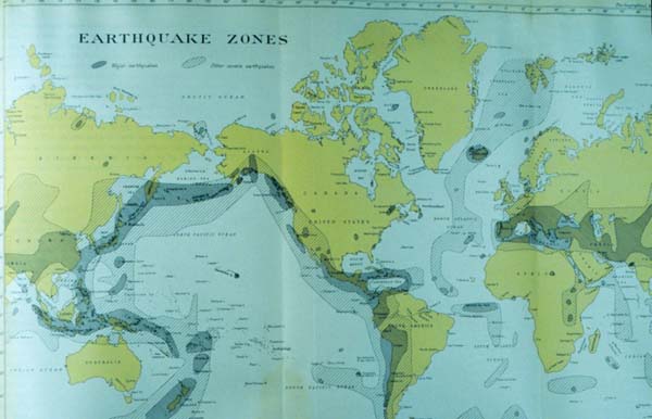
"Earthquake Zones" by Captain Nicholas Heck, U.S. Coast and Geodetic Survey. Heck first produced a world seismicity map showing the activity on the Mid-Atlantic Ridge in 1932. (Courtesy of NOAA Photo Library.) Download larger version (jpg, 59 KB).
"The large number of recorded earthquakes along the ridge is quite significant and many reports exist of earthquakes prior to the instrumental period recorded by passing vessels...”
Presented by Nicholas Heck at the Symposium on the Application of Seismology to the Study of the Ocean-Basins in: “Seismology and the Ocean-Basins”, pp. 91-94, Transactions of the American Geophysical Union, Thirteenth Annual Meeting, April 28 and 29, 1932. National Research Council, Washington, D.C.
1939
The Theory of Continental Drift as Poppycock
In 1939, Andrew Lawson, a well-known elder statesman of geology of the era, was shown a home-made movie and working model demonstrating how thermal convection in the earth's crust could lead to mountain building. His response was typical of the time and is suggestive of why Alfred Wegener's theory of continental drift fell into disrepute in the United States: "I may be gullible. I may be gullible! But I am not gullible enough to swallow this poppycock."
As quoted in Challenger at Sea: A Ship That Revolutionized Earth Science (1992) by Kenneth Hsu. p. 57.
1940
Looking for Atlantis: A Suggestion to Survey the Mid-Atlantic Ridge
"Several years ago Professor Richard M. Field, Chairman of the Commission on Continental and Oceanic Structure of the International Union of Geodesy and Geophysics, suggested to the author the desirability of a hydrographic survey of the Atlantic Ridge and inquired as to its feasibility. It is the purpose of this article to propose a modern hydrographic survey of the Ridge and to describe from the standpoint of a practical hydrographer tentative plans, including methods and technique, adequate for a survey as well controlled as those made in recent years over the continental shelves off the North American coasts.”
In "A Survey of Atlantis" by (1940) Captain G. T. Rude of the U. S. Coast and Geodetic Survey in United States Naval Institute Proceedings, Vol. 66, No. 8, Whole No. 450, pp. 1105-1123. August 1940.
1941
The Changing Sea and Earth
" . . . the sea, too, lay restless, awaiting the time when once more it should encroach upon the coastal plain, and creep up the sides of the foothills, and lap at the bases of the mountain ranges . . . so the relation of sea and coast and mountain range was that of a moment in geologic time. For once more the mountains would be worn away by the endless erosion of water and carried in silt to the sea, and once more all the coast would be water again, and the places of its cities and towns would belong to the sea.”
In Under the Sea-Wind: A Naturalist's Picture of Ocean Life (1940) by R. Carson. Published by Simon and Schuster, New York. p. 271.
1951
The First Modern Deep Ocean Sounding
"On the 3rd of January, in Latitude 27degrees, 26 minutes S., longitude 17 degrees, 29 minutes W., the weather and all other circumstances being propitious, we succeeded in obtaining soundings with two thousand four hundred and twenty-five fathoms of line, a depression of the bed of the ocean beneath its surface very little short of the elevation of Mount Blanc above it.” Sir James Clark Ross, in command of Her Majesty’s ships Erebus and Terror, en route to the Antarctic continent. This was the first successful deep-sea sounding ever taken (Jan. 3, 1840).
As quoted in The Sea Around Us (1951) by R. Carson. Published by Oxford University Press, New York. p. 56.
1955
The Pioneer Survey
In reference to the magnetic surveys conducted by the Coast and Geodetic Survey Ship Pioneer in 1955: “... one of the most significant geophysical surveys ever made....” This survey was funded by the Navy for determining offshore bathymetry on the west coast. The Scripps Institution of Oceanography funded using the first shipboard towed magnetometer from the Pioneer. This convergence of interests led to the discovery of magnetic striping on the sea floor, a key element in formulating the theory of Plate Tectonics.
In The Ocean of Truth (1986) by H. W. Menard. p. 73. Published by Putnam, New York.
1960
Man at the Deepest Depth
On January 23, 1960, the bathyscaph Trieste reached the greatest oceanic depth existing on our planet. Jacques Piccard and Lieutenant Don Walsh of the United States Navy, piloted the Trieste to the sea floor in the deepest part of the Marianas Trench, known as the Challenger Deep. Although their onboard depth indicator registered 37,800 feet, this was later corrected to 35,800 feet as the result of calculations by Dr. John Knauss (a future administrator of NOAA) and Dr. John Lyman. This is Jacques Piccard’s description of what he saw on this dive to the deepest part of the sea:
"The bottom appeared light and clear, a waste of snuff-colored ooze. We were landing on a nice, flat bottom of firm diatomaceous ooze. Indifferent to the nearly 200,000 tons of pressure clamped on her metal sphere, the Trieste balanced herself delicately on the few pounds of guide rope that lay on the bottom, making token claim, in the name of science and humanity, to the ultimate depths in all our oceans - the Challenger Deep."
"The depth gauge read 6,300 fathoms - 37,800 feet. The time - 1306 hours."
".... And as we were settling this final fathom, I saw a wonderful thing. Lying on the bottom just beneath us was some type of flatfish, resembling a sole, about 1 foot long and 6 inches across. Even as I saw him, his two round eyes on top of his head spied us - a monster of steel - invading his silent realm. Eyes? Why should he have eyes? Merely to see phosphorescence? The floodlight that bathed him was the first real light ever to enter this hadal realm. Here, in an instant, was the answer that biologists had asked for the decades. Could life exist in the greatest depths of the ocean? It could! And not only that, here apparently, was a true, bony teleost fish, not a primitive ray or elasmobranch. Yes, a highly evolved vertebrate, in time’s arrow very close to man himself. Slowly, extremely slowly, this flatfish swam away. Moving along the bottom, partly in the ooze and partly in the water, he disappeared into his night. Slowly too - perhaps everything is slow at the bottom of the sea - Walsh and I shook hands."
In Seven Miles Down: The Story of the Bathyscaph Trieste (1961) by J. Piccard and R. S. Dietz. pp. 172-174. Published by the Putnam, New York.
1974-1
The Mid-Atlantic Rift Valley as Girl Talk
The discovery of a rift valley in the center of mid-ocean ridges was one of the most significant bathymetric discoveries ever made. In 1952, Marie Tharp was a draughtsman for Bruce Heezen and others working at Lamont Geological Observatory in New York. Bruce Heezen related the following story concerning the realization that a rift valley existed in the middle of the Mid-Atlantic Ridge: "Marie's job for me was to decide what a structure was --- whether a rise in the echo soundings represented a hill or something longer like a ridge --- and to map it. In three of the transatlantic profiles she noticed an unmistakable notch in the Mid-Atlantic Ridge, and she decided they were a continuous rift valley and told me. I discounted it as girl talk and didn't believe it for a year."
As quoted in The Floor of the Sea (1974) by William Wertenbaker. p. 144.
1974-2
The Mid-Ocean Ridge
"Imagine millions of square miles of a tangled jumble of massive peaks, sawtoothed ridges, earthquake shattered cliffs, valleys, lava formations of every conceivable shape -- that is the Mid-Ocean Ridge."
Maurice Ewing as quoted in: Wertenbaker, William, 1974. "The Floor of the Sea," p. 153.
Address the slow and sometimes frustrating process of how humankind has learned about the basins, the seamounts, the fracture zones, the trenches, and the great globe-girdling rift system that make up the floor of the sea. What is the significance of these features in the evolution of the surface of our planet? Join the continuum of ocean explorers who have determined the nature of our seafloor and its relationship to our planet.

The 1897 contoured map of Monterey 'Submerged Valley' as published by George Davidson in the Proceedings of Calif. Acad. of Sciences. Monterey Canyon was first discovered in 1857 by the Coast Survey, and termed a 'submarine gulch.' (Courtesy of NOAA Photo Library.) Download image (jpg, 56 KB).