By Ryan Smith - NOAA’s Atlantic Oceanographic and Meteorological Laboratory
Villy Kourafalou - University of Miami’s Rosenstiel School of Marine and Atmospheric Science
Arnoldo Valle-Levinson - University of Florida

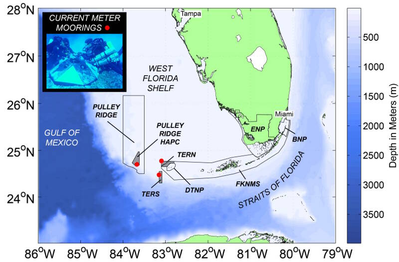
Figure 1. The locations of the three NOAA-funded, bottom-mounted physical oceanography moorings are shown with red dots at Pulley Ridge and in the Dry Tortugas. Each mooring contains an acoustic Doppler current profiler (or ADCP) and a temperature/salinity recorder. Project divers service these moorings annually to recover data, clean the sensors, and replace instrument batteries (inset). The numerous marine protected areas located across the region are also indicated. Map courtesy of Ryan Smith, NOAA’s Atlantic Oceanographic and Meteorological Laboratory. Inset image courtesy of Mike Echevarria, Florida Aquarium. Download larger version (jpg, 374 KB).
Ocean currents around South Florida drive important physical connectivity between the coral reefs of Pulley Ridge, the Dry Tortugas, and the Florida Keys. Two or more marine ecosystems can be physically connected when water is transported quickly from one location to the other, with little or no change in the water’s properties along the way. If the water also carries marine organisms (such as fish larvae) from the first site to the next, and those organisms survive and populate the downstream ecosystem, then the locations can be biologically connected as well.

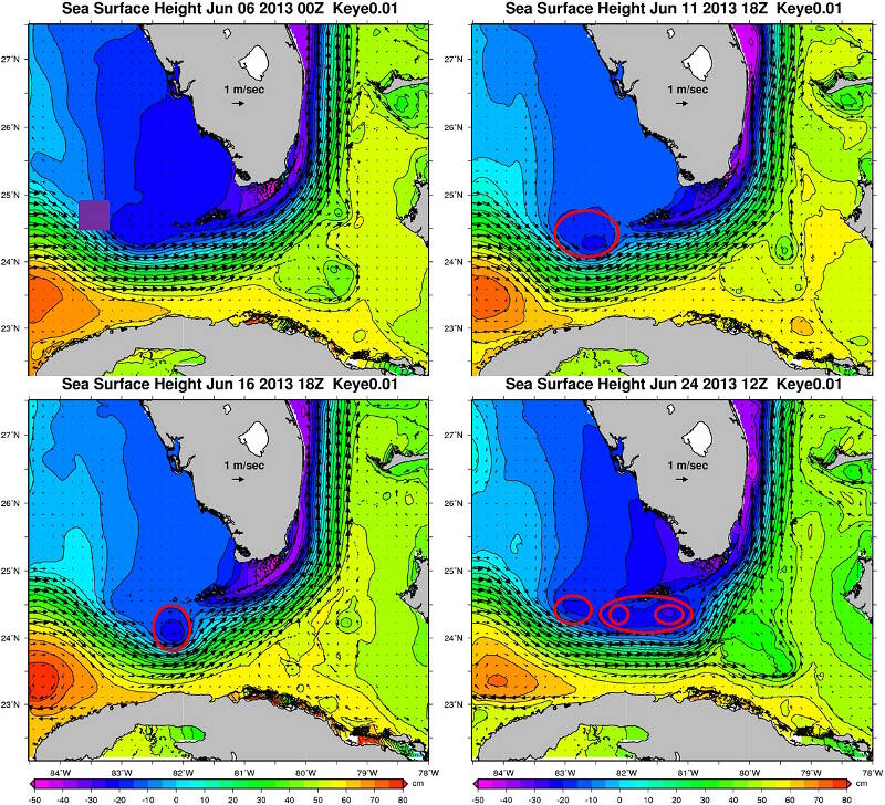
Figure 2. Sea surface height and surface currents (color contours and black arrows) calculated from the FKEYS-HYCOM model are shown above for four dates in June 2013. The plot boundaries represent the model domain. The location of the project's current meter moorings is indicated in the upper left-hand panel with a purple square. Note the cyclonic (counter-clockwise) circulations (circled in red) south of the Keys, deflecting the Florida Current farther to the south in the Straits of Florida. Image courtesy of Villy Kourafalou, University of Miami’s Rosenstiel School of Marine and Atmospheric Science. Download larger version (jpg, 851 KB).
This project offers the first major opportunity to explore the physical and biological connectivity between the reefs of Pulley Ridge and the Florida Keys. The project aims to develop tools that resource managers can use to develop effective strategies for protecting these ecosystems.

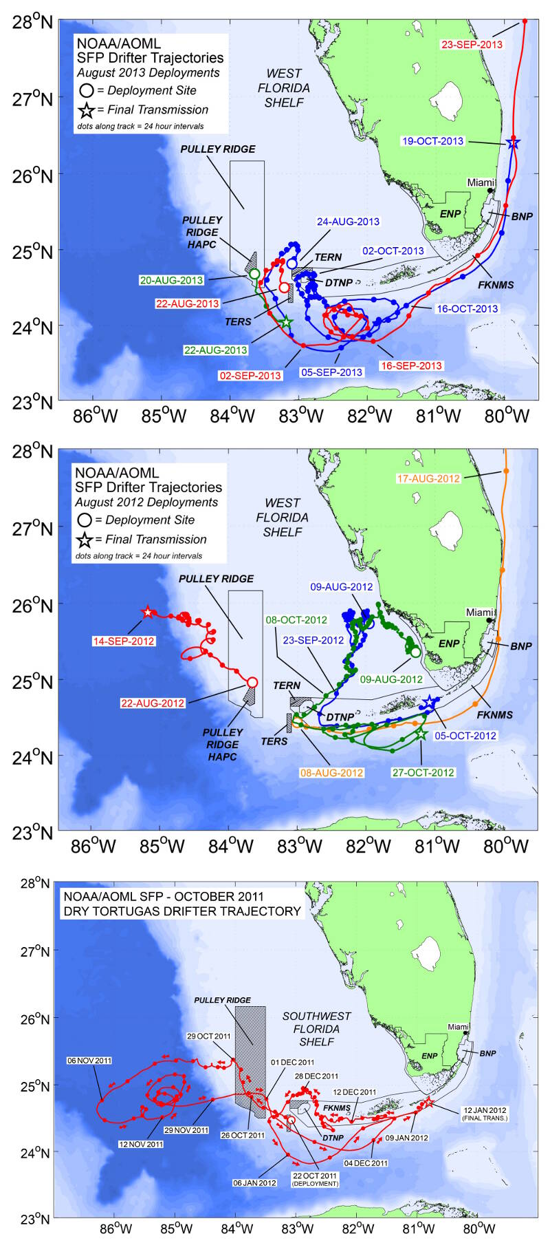
Figure 3. Shows trajectories from surface drifters deployed around the region in 2011, 2012, and 2013. These tracks exemplify the highly variable circulation pathways that affect south Florida’s coastal marine ecosystems. Image courtesy of Ryan Smith, NOAA’s Atlantic Oceanographic and Meteorological Laboratory. Download larger version (jpg, 1.8 MB).
South Florida’s reef communities are affected by a complex system of currents including shelf and coastal currents (driven by the wind and tides), as well as deep oceanic currents associated with the Gulf Stream. Pulley Ridge, the Dry Tortugas, and the Florida Keys are influenced by two branches of the Gulf Stream: the Loop Current, located in the Gulf of Mexico, and the Florida Current, which flows through the Straits of Florida between Florida, Cuba, and the Bahamas.
These fast-moving currents (reaching speeds of about 5 knots) can connect Florida reefs with remote coastal ecosystems such as the Mississippi River and the Mesoamerican Barrier Reef System. For instance, Mississippi river water rich in nutrients or lobster larvae spawned on the reefs of Belize, can be carried by these currents and deposited along the Florida Keys, affecting local water quality and fisheries.
The pathways and travel time of entrained materials, such as fish larvae or pollutants, are controlled by the varying configurations of the Loop and Florida Currents and their associated eddies (recirculating features that travel along the edges of these currents).
The Loop Current enters the Gulf of Mexico through the Yucatan Strait (between Mexico and Cuba) and either: (1) turns quickly to the east directly entering the Straits of Florida (known as a young Loop Current), or (2) extends northward to some degree, toward the Mississippi Delta, before heading back south (an extension reaching far into the northern Gulf is called a mature Loop Current). In the Florida Straits, the Florida Current can meander from positions near the Florida Keys to near Cuba and/or the Bahamas.
Eddy circulation along the edges of these currents can also capture materials, transport them hundreds of miles, and deliver them to remote locations. In the Straits of Florida, eddies can trap coral reef fish larvae at spawning grounds in the Dry Tortugas and deliver them to other reefs along the Florida Keys. This has been shown to be an important mechanism for replenishing reef fish stocks in the Keys.
In an effort to gain a better understanding of how these varying pathways influence the currents observed at Pulley Ridge and its potential connectivity to the downstream reefs of the Florida Keys, starting in 2012, we deployed oceanographic instruments on moorings at Pulley Ridge and the Dry Tortugas (Figure 1) and began developing computer models for the study area. Our hydrodynamic model is the Florida Straits, South Florida, and Florida Keys Hybrid Coordinate Ocean Model (FKEYS-HYCOM). This model will interface with a biological model to look at the potential biological/population connectivity of marine organisms across the region.
In addition to observations from ships and moorings, we use computer model simulations because they can provide a uniform data set across their entire coverage area, or domain, rather than from an individual location (such as a measurement from a research vessel or moored instrument).
Our FKEYS-HYCOM domain (Figure 2) has been extended westward to provide complete coverage of Pulley Ridge. The domain also includes the Florida Keys, the southwest Florida shelf, and all of the Straits of Florida. This model is nested within a full Gulf of Mexico regional model and has a horizontal resolution of 900 meters and 26 vertical layers. Its spatial resolution allows the model to reproduce small-scale circulation processes affecting the study area. The hourly measurements of ocean temperature, salinity, and current velocity recorded at each of the mooring sites are used to validate the model’s performance.
Additionally, satellite-tracked surface drifting buoys have been deployed during each research cruise on the R/V F.G. Walton Smith to help us directly track the regional circulation patterns occurring during these surveys. The variability of these drifter trajectories (Figure 3) illustrates the complex nature of south Florida’s coastal ocean circulation.
Measurements collected during the first year of our project show that the direction and magnitude of daily mean currents observed at Pulley Ridge are greatly influenced by the configuration of the Loop Current. Over this period, we observed both the direct and indirect influence of the Loop Current on local circulation at Pulley Ridge. Our corresponding computer model results for current flow at Pulley Ridge were compared with our moored data set and were found to be in good agreement. This suggests that our model is successfully simulating the regional circulation.
Activities related to the physical connectivity portion of the project are being conducted on both the M/V Spree and R/V F.G. Walton Smith cruises this summer. On the Spree in June 2014, divers successfully recovered data from all three physical oceanography moorings and deployed three drifters to measure surface currents.
During the R/V F.G. Walton Smith cruise in August, we will use hull-mounted oceanographic instruments to collect continuous data, including upper ocean current velocity and sea surface temperature, salinity, and chlorophyll.