


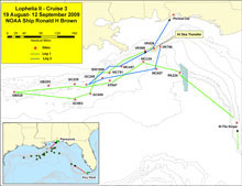
This map shows the proposed cruise track for the 25 days the Lophelia II 2009 expedition will be at sea. The cruise leaves out of Key West, Florida, on August 19 and ends in Pensacola on Sept 1. During this period, researchers hope to visit 17 different sites. Click image for larger view and image credit.
Lophelia II
Deepwater Coral Expedition: Reefs, Rigs, and Wrecks
Lophelia II 2009 marks the second year of a four-year study, and the third cruise in a series of four expeditions to the Gulf of Mexico. We will be on board the NOAA ship Ronald H. Brown, the flagship of the NOAA fleet, and will be using one of the most advanced remotely operated vehicles (ROV) in the world, the Jason II from Woods Hole Oceanographic Institution. There are many facets to this study, and we have included a multi-disciplinary team of scientists from some of the leading institutions in the world to help us accomplish all of our goals.
The most basic goal of this study is to be able to predict deep-water coral distribution in the Gulf of Mexico. The NOAA Office of Ocean Exploration and Research (OER) and the U.S. Minerals Management Service (MMS) are interested in this question so they can better protect these fragile habitats as human activities extend offshore into deeper and deeper waters. Read more . . .
Finding Corals in the Deep
How can we tell where deep-water corals live? This is not a simple question. If we want to find shallow-water corals we can look from the beach, or at photographs taken from a plane or even a satellite. Unfortunately, we can’t look through hundreds or thousands of meters of water to find deep-water corals. So we are developing some other tools that can be used to help predict coral distribution.
Before we went out to sea on this cruise, we spent a lot of time going through remote sensing data of the seafloor. MMS houses all of the oil industry-generated seismic data from the Gulf of Mexico. These data give you a picture of how “reflective” the surface of the seafloor is to sound (an exploration method using sound waves), which can tell you a lot about how soft or hard the surface is. Because corals need a hard substrate to settle on, we need to find areas where there are rocks exposed on the seafloor. The seismic data tells us even more since it is three-dimensional, meaning that we can see the structure underneath the seafloor and get a better idea of what the conditions are on the bottom.
We found a number of areas that appear to be suitable for coral growth, but we then needed to get a closer look at them. We got that look from a combination of high-resolution multibeam bathymetry taken from the NOAA ship Nancy Foster and the autonomous underwater vehicle (AUV) Sentry from Woods Hole Oceanographic Institution, and also imagery of the seafloor from the AUV Sentry and the ROV Seaeye Falcon. These two cruises gave us our first tests of how well we could predict coral distribution, and helped us choose the sites where we would carry out some of the detailed experiments and deployments we will make on this cruise.
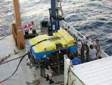
The remotely operated vehicle Jason II on the back deck of the NOAA ship Ronald H. Brown are shown here during a research cruise to the Gulf of Mexico, in 2007. Click image for larger view and image credit.
Leg I — Coral Communities in the Deep Gulf
We will start this cruise in Key West, Florida, and will head to a site off the west coast of Florida to examine our first coral communities. Some of these communities have been visited before, but we will also survey some areas that look very promising but have not been previously observed. We will collect quantitative photographic and physical samples of coral communities and genetic samples of the hard coral Lophelia pertusa, black corals, gorgonian sea fans, and associated species to give us some information on how similar these communities are to those in the northern Gulf.
We will then move north to our deepest site where we will examine a cliff face that runs over 1,000 meters (3,281 feet) from top to bottom. No one has ever explored this site, so we don’t know what we might find. The next few sites we explore will be based on our best guesses as to where corals might be — another test of our predictive capabilities. Stay tuned for the results as we cross the Gulf from Florida to Texas.
As we head back from our western sites to the central Gulf, we will begin our more detailed work at known coral sites. The first will be Green Canyon 852, the site of the coral gardens discovered during our 2007 mission to explore cold seeps in the Gulf. We will deploy the first of our long-term instruments here, a current-meter array to tell us about the physical oceanography of this part of the Gulf at 1,400 m (4,593 ft) depth. We will then go to a few of the sites we discovered during the survey cruises, Mississippi Canyon 751 and Viosca Knoll 906. These two sites contain very different types of coral colonies; the first with lots of live coral growing near a cold seep site, and the second with large mounds made up of mostly dead coral. We will place our next piece of long-term gear at the Mississippi Canyon site: the sediment/larval trap. This piece of equipment will collect samples every two-to-three weeks for an entire year. The samples can be analyzed to tell us how much food is being delivered to the corals, how much they might get buried by sediment, and how frequently larvae make it to the site.
The final site of the first leg is a visit to the largest known Lophelia reef in the Gulf: Viosca Knoll 826. We will deploy a time-lapse camera, another current-meter array, and another sediment/larval trap; and we will make lots of collections here. The collection will be for community structure, genetics, and for the live corals we will need for our experiments back in the lab.
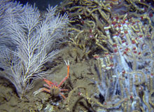
An example of the Mississippi Canyon 751 site, where coral and cold seep habitats intersect. On the left is the gorgonian coral Callogorgia americana, which is one of the species we will focus on for our genetic studies. Click image for larger view and credits.
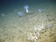
An example of the Viosca Knoll 906 habitat. In a part of this site, we see series of mounds that appear to be composed primarily of dead Lophelia pertusa rubble. Click image for larger view and credits.
Leg II — Shipwrecks and Corals
While we are at Viosca Knoll, a boat will meet the ship and exchange 12 people for the second leg of the cruise. The second leg will involve more investigations of the shipwrecks in the area, some known to have large Lophelia colonies on them, and some completely unknown! There will be a few artifacts preserved from the wrecks, microbiological deployments made, and some corals samples taken. We will finish the cruise with one more visit to the main site at Viosca Knoll and then we will head into shore. Hopefully, this cruise will go a long way towards helping us predict coral distribution and learn more about the biology, ecology, and geology of these ecosystems.