


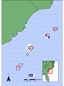
Researchers surveyed proposed Marine Protected Areas (boxed in red) and sites with sonar (shown as white boxes with bottom images) along the edge of the continental shelf. Additionally, they surveyed an area on the Charleston Bump, an important deep-water coral and fish habitat. Click image for larger view and image credit.
Sonar Mapping of Deep Reef Sites off South Carolina
Biologically Engineered and Other Complex Habitats at the Shelf Edge and Upper Slope of the South Atlantic Bight
August 19 - 30, 2006
George R. Sedberry
South Carolina Department of Natural Resources
The sea floor on the continental shelf and slope off the southeastern United States includes vast areas of smooth sandy bottom. Interspersed on the smooth bottom are rugged rocky outcrops. These rocky reefs range in height from a few inches to several hundred feet, and in area from small patches to hundreds of square miles. This rugged hard bottom provides substrate (a surface on which an organism grows or is attached) for sponges, corals, and other invertebrates, and is a favored habitat of many species of fish, including important fishery species. Snappers, groupers, porgies, and many other fisheries species are attracted to the complex bottom habitats provided by rocky relief. In addition to its protruding rocks, the habitat is often further altered by living organisms (including the fishes themselves) in ways that make it more useful and attractive to other fishes and organisms. We refer to these habitats as being "biologically engineered."
Tropical coral reefs are spectacular examples of biologically engineered complex habitats. The reef structure, built up by billions of living coral polyps, provides habitat for sponges, corals, crabs, worms, fishes, and all kinds of marine plants and animals. Off the southeastern U.S., hard corals and worms that produce reefs of hard calcareous (containing calcium carbonate) tubes also build up reefs and construct complex habitats on the outer continental shelf and upper slope. Fishes often excavate soft bottom and the sandy areas around reefs, creating complex habitats used by other organisms. Rock, coral, and worm reefs have been observed visually from submersibles on our previous Ocean Exploration (OE) expeditions, and they contain many more fishes than nearby (but less complex) habitats.
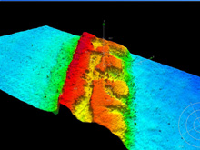
This image shows a portion of the shelf-edge reef, at about 180 ft depth, included within the proposed Edisto Marine Protected Area off South Carolina. This is an important spawning site for several important reef fishes, including scamp grouper and vermillion snapper. Click image for larger view and image credit.
During our South Atlantic Bight 2006 expedition, we wanted to use state-of-the-art sonar to rapidly map rock, coral, and other physically and biogenically formed bottom features of the outer continental shelf and upper slope off South Carolina. These habitats consist of low- to high-relief hard grounds and rocky reefs, smooth sand or mud, and mud that has been excavated by tilefish. In addition to tilefish burrows, other biologically engineered habitats include grouper and triggerfish excavations, worm reefs, and coral reefs. We are particularly interested in mapping habitats that are spawning grounds of reef fishes, especially those species that form aggregations by migrating to specific locations or habitat features.
This mapping will complement previous and current NOAA-funded projects aimed at determining the factors that constitute spawning grounds for reef fishes, especially deep-reef species. We need sonar mapping and the groundtruthing of sonar signatures (using video cameras on remotely operated vehicles) around known spawning locations in order to determine the characteristics that make them attractive to spawning reef fishes. By characterizing the sites with sonar (groundtruthed with visual observations), we can then use rapid sonar surveys to map other lesser-known or previously unknown spawning locations, and to discover additional essential fish habitat. In addition, many fishes build nests during spawning, or otherwise alter the bottom in ways that show up on sonar records; those records can be used to map spawning and residence areas for fishes that “bioengineer” the bottom.
Three-dimensional bottom complexity excavated by fishes or built up by corals and reef-building tube worms supports numerous other organisms. As part of their missions, OE and other NOAA programs are mapping deep coral banks and investigating their diversity and ecology. Side scan sonar surveys of shelf-edge reefs conducted by us on previous OE expeditions revealed mounds, pockmarks, and excavations (pits) similar to those seen in the Gulf of Mexico. Such habitat modification by fishes (e.g., red grouper, gray triggerfish) and physical processes (e.g., gas seeps) create additional habitat complexity that is utilized by a variety of species, although the biological relationships and behaviors have not been thoroughly investigated.
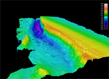
A portion of a scarp feature on the Blake Plateau off Georgia. Over 300 ft high, this scarp is an important spawning and fishing ground for wreckfish. The feature is part of the "Charleston Bump" that causes meanders of the Gulf Stream. Click image for larger view and image credit.
During the cruise aboard the NOAA Ship Nancy Foster, we used multibeam sonar to map bottom topography in areas that are important fish habitats and spawning grounds as determined from historical fishery-independent sampling, commercial landings, and complementary studies already funded by NOAA. We also used side scan sonar to map smaller features, particularly those features excavated by fishes, such as tilefish burrows and red grouper pits (depressions). We used side scan sonar to map low mounds built by tube worms, coral mounds, solution holes, gas seeps, and other small-scale features.
Many of the known spawning areas that were surveyed are in federally proposed Marine Protected Areas (MPAs), where bottom-fishing will be prohibited. Areas adjacent to the MPAs were also mapped, in order to map the extent of the habitat within and outside of proposed MPAs. Although fishermen and scientists have known about the existence of this reef, the new maps track its extent along the shelf edge, including its extension well beyond the proposed no-fishing zones. The sonar records we collected from the shelf edge indicate a narrow ridge of reefs that will remain open to fishing, yet will pass through no-fishing zones that will protect part of the population, particularly the large spawning female fish.
The sonar imagery will collectively provide habitat maps for the region and assist future researchers, fishery managers, students, and educators interested in features of the ocean floor that are important in producing and sustaining fish and fisheries.