


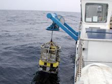
The R/V Seward Johnson's ROV is launched to search out the Snowy Wreck. Click image for larger view.
The Search for the Snowy Wreck
August 18, 2003
Ken Sulak, PhD
Research Fish Biologist
U.S. Geological Survey
Chief Scientist
Life on the Edge Expedition
![]() Video of ROV launch, wreck and recovery. (mp4, 3.6 MB)
Video of ROV launch, wreck and recovery. (mp4, 3.6 MB)
Two more Johnson-Sea-Link II manned submersible dives were scheduled for today, but strong waves combined with opposing winds would make it too difficult to launch the JSL II at the second planned site, the Southern Lophelia Banks on the Outer Shelf Reef. So, the day’s science plan was revised. We headed inshore to find calmer seas and the opportuntity to launch the ship’s remotely operated vehicle (ROV) over an alleged wreck site on the Outer Continental Shelf (OCS) of North Carolina.
Along with the enticement of this mystery wreck, the OCS is rich in living marine resources, including the groupers and snappers so important to the region's commercial and sport fisheries. Proposals have been issued recently to manage such resources by establishing marine reserves or protected areas. Protecting parts of the OCS from fisheries harvest is an important management strategy for preserving the fish populations that sustain these fisheries. A marine protected area (MPA), an area that has been reserved by law or other effective means to conserve the enclosed environment, fauna, etc., has been proposed for a small portion of the North Carolina OCS to allow fish populations to replenish themselves naturally. Ideally, this MPA will afford some level of protection for the purpose of safeguarding ecosystem function and biodiversity.
Hard-bottom areas within this proposed MPA would provide habitat for the shelter and spawning of reef-dwelling fish species. Human artifacts, such as sunken ships, also contribute to three-dimensional habitat used by fishes. Lying within the boundaries of the proposed North Carolina MPA at a depth of 800 ft is an apparently productive bottom feature long referred to by fishermen as the “Snowy Wreck." This feature likely gets its name from deep-dwelling snowy groupers harvested in the area. It is not well known except by a few fishermen, and it cannot be located on previously published maps. In fact, the true identity of this feature has never been confirmed by direct underwater observation, though it returns a substantial signal on fathometer recordings.
The ROV was deployed to find an isolated and as yet unidentified feature that commercial fishermen have nicknamed the "Snowy Wreck."
![]() Click image to view video. (mp4, 3.6 MB)
Click image to view video. (mp4, 3.6 MB)
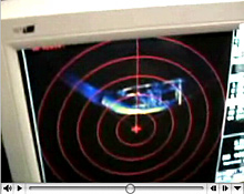
Fortunately, our steam inshore enabled us to deploy the ROV that resides aboard our research vessel (R/V), the Seward Johnson, to investigate the true nature of the Snowy Wreck. Operated from the mother ship, the ROV, guided by scanning sonar, carefully approached the unknown feature on the bottom. As we were waiting for the ROV video, the color image on the sonar screen located in the ROV control "van" on the aft deck of the ship quickly confirmed that the feature was indeed a ship wreck. The sonar diplayed the characteristic shape of a boat hull resting upright on level terrain. Maneuvering closer, the ROV's video cameras revealed a steel-hulled vessel with an ornate rail and a single mast amidships. A dense growth of anemones and other invertebrates covered the ship’s hull, now a permanent part of the underwater world. And, although the water was very turbid, and visibility was limited, several large groupers could be seen cruising over the hull, perhaps confirming that the wreck is aptly named.