


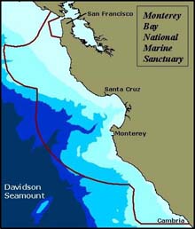
Davidson Seamount, a huge underwater volcano, is located just outside the boundary of the Monterey Bay National Marine Sanctuary. Image courtesy Montery Bay Aquarium Research Institute (MBARI) Click image for larger view.
Mission Plan
Andrew DeVogelaere
Chief Scientist, Davidson Seamount Exploration
Monterey Bay National Marine Sanctuary
Introduction
The Davidson Seamount is an impressive geologic feature that has intrigued people since it was first mapped as a “sea mountain” in 1933. The site's location and depth, however, have precluded all but a few brief scientific investigations. These glimpses have been of a place that appears fascinating and unique, and now, we have the technology to document the habitats and species there. The mission of our exploration is to more fully characterize the Davidson Seamount. We will document species, take geologic samples, and describe the ocean environment. Our team of explorers includes scientists, educators, and resource managers, with the goal of sharing discoveries of the Davidson Seamount through this Web site.
The Davidson Seamount
The Davidson Seamount is located 120 km southwest of Monterey, California. The seamount is an inactive volcano roughly as tall as the Sierra Mountains (2,300 m) and as wide as Monterey Bay (40km), yet its summit is far below the ocean surface (1,300 m). This geologic feature is so impressive that it was the first to be called a “seamount” and is named after George Davidson, a famous marine scientist. (Read more about George Davidson ![]()
![]() .)
.)

The Davidson Seamount is 40 km long and rises 2,300 m from the ocean floor, yet it is still 1,300 m below the surface. Image courtesy MBARI.
Who is Interested, and Why?
If you could see a huge mountain peak as you walked out your door, would you dream of climbing it? Marine scientists can't look out their windows into the deep sea, but many are surrounded by maps everywhere they work. Davidson Seamount is a huge volcano just outside the boundary of the Monterey Bay National Marine Sanctuary, and we want to explore it. Volcanologists want to understand how this unique geologic feature was formed, deep-sea biologists want to know what lives on it, and, because seamounts affect ocean currents around it, other biologists wonder what's happening above it. We suspect that the water above Davidson may be a “hot spot” for sperm whales, and it has been suggested that they may be feeding on giant squid far beow the surface. In 2000, all of this interest made its way back to Washington, DC, when the President mentioned Davidson Seamount in the announcement to launch a new era of ocean exploration (pdf document, 32 kb).
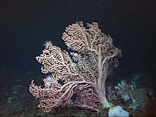
In contrast to other local seamounts, Davidson Seamount has many old coral forests, with individuals reaching more than 3 m high. Image courtesy MBARI Click image for larger view.
Sampling and Technology
Using the most advanced marine technology, our explorers will delve deeper into describing the Davidson Seamount. We are fortunate to have the Monterey Bay Aquarium Research Institute (MBARI) as one of our partners, as its research vessel Western Flyer provides a state-of-the-art platform for the deep diving robot Tiburon. We will record video and quantify habitats on the top, bottom, and both sides of the seamount. Species that are hard to count with video will be caught in baited traps. When we find appropriate samples, we will collect organisms to display at the Monterey Bay Aquarium and gather rocks for geology studies. Meanwhile, at the surface, a team will count seabirds and mammals. If a sperm whale or leatherback turtle is seen, the chase will be on. A small boat will race away from the Western Flyer to tag these rare species.
What Will we do with our Findings?
Besides satisfying the curiosity of many people who will share this expedition with us through the Web and later publications, we will support scientific, resource management, and education endeavors. We will find new species and develop new hypotheses on how communities of species interact on a seamount. These will be pursued later with more focused scientific expeditions. We will better understand the geologic processes that form seamounts. Better education displays on seamount habitats will become available to the public. As the Monterey Bay National Marine Sanctuary Management Plan ![]()
![]() is being reviewed, one option is to include the Davidson Seamount within its boundaries. Our work may also help resource managers make a decision regarding this option as they endeavor to conserve and protect the species and habitats there.
is being reviewed, one option is to include the Davidson Seamount within its boundaries. Our work may also help resource managers make a decision regarding this option as they endeavor to conserve and protect the species and habitats there.
Sign up for the Ocean Explorer E-mail Update List.