Meet Brandon O'Brien
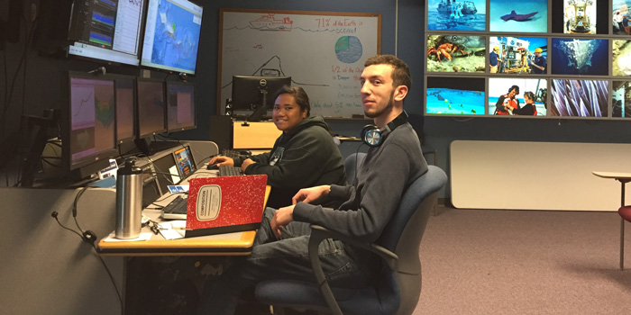
Brandon O'Brien is here with Claudia Thompson hard at work in the Exploration Command Center at the University of New Hampshire's Center for Coastal and Ocean Mapping. Read the full text of Brandon's interview below to learn more about his experiences on the ship.
About Brandon's Role
What were your duties as an Explorer-in-Training?
I had the opportunity to work as an Explorer-in-Training both onshore during the Telepresence Mapping in American Samoa and the Cook Islands expedition and offshore during the Musicians Seamounts Telepresence Mapping expedition.
My duties primarily involved processing raw sonar data as it was being transmitted from the ship. The Okeanos Explorer maps 24 hours a day, so there was always new data coming in for myself and the other EiT to work on. After the raw data was cleaned up, it was used to create high resolution maps of the areas the ship had surveyed.
Which school are you attending?
As of fall 2017, I am beginning a Ph.D. in marine biology at the University of New Hampshire. My research will focus on the ecology and biogeography of marine macroalgae (aka, seaweeds).
Where was your work experience located? If you were working at sea, what were your impressions of living and working on a ship?
During the Telepresence Mapping in American Samoa and the Cook Islands expedition, I worked on the University of New Hampshire campus at the Center for Coastal Mapping/Joint Hydrographic Center. More specifically, I was at the Exploration Command Center (ECC) there, which is an office designed specifically to allow for telepresence interaction with NOAA ships offshore from the comfort of Durham, New Hampshire. It was great to be able to learn the ropes of the job in a calm and lower stress environment onshore.
In August, I boarded the Okeanos Explorer in Honolulu to sail onboard the Musicians Seamounts Telepresence Mapping expedition. Thanks to the onshore training, I was able to jump right into my duties processing sonar data with just a brief refresher.
Living at sea has its challenges, such as odd sleep schedules, close quarters, and constant rolling, but I adjusted quickly and thoroughly enjoyed my time onboard. It was interesting to see the workings of the sonar systems firsthand and also the interactions between the mapping team and the rest of the Okeanos Explorer crew. Without the skilled piloting of the officers, the technical services of the deck and engineering departments, and hearty food from the kitchen, no mapping could ever get done!
Finally, there is something indescribably calming about being hundreds of miles from land with nothing but open ocean in every direction. After a long eight-hour watch, I cherished spending quiet evenings on deck watching the sun set.
What sparked your initial interest in ocean sciences?
Growing up on Long Island and spending my summers on wide sandy beaches, I have always loved the salt air, cool waters, and collecting seashells. During my undergrad at Cornell University, I majored in Natural Resources with an emphasis on population dynamics. However, taking a summer course at Shoals Marine Lab rekindled my love for the ocean and convinced me to alter my academic course to follow my beachcomber’s heart. Since then, I have pursued my interests in ocean science and marine ecology.
What was the most personally rewarding part of your experience?
For me, it was rewarding to know that I had a part in exploring some of the great unknown areas of the sea. Most of the areas that the Okeanos Explorer surveyed have never been mapped in such high resolution before. I was lucky to be among the first to see the fine details of these seamounts and to view interesting and previously unseen geologic features on the seafloor. Seeing the completed maps at the end of the cruise, of newly revealed areas on the other side of the globe, really drove home the scale of the amazing endeavor that I participated in.
Please describe your final project.
For the Telepresence Mapping in American Samoa and the Cook Islands expedition, I created a series of high-resolution maps showing various properties of the seafloor around Samoa, the island of Tau, and two unnamed seamounts to the east.
Later, the Musicians Seamounts Telepresence Mapping expedition, I produced a series of processed backscatter images for three areas: Blackfin Ridge, part of the Murray fracture zone, and some of the Musicians Seamounts.
How do you see this experience fitting in with your future career plans?
I will soon be starting a Ph.D. program at the University of New Hampshire in Marine Biology. I plan to study the benthic ecology of various macroalgae and the change in its geographic distributions over time. My work here at NOAA has given me useful experience with mapping software that I will continue to use in the future. In addition, I hope to integrate some remote sensing of benthic habitats into my research, and what I’ve learned here about using bathymetry and backscatter data will be helpful.