

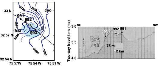
The bathymetric map on the left shows the location of the three Cape Fear diapir Ocean Drilling Program sites from Leg 164 (Sites 991 through 993), with the gray area marking reflective sea floor. The image on the right was collected with a standard 3.5 kHz system and provides only limited detail about the subseafloor. Both figures are adapted from the Initial Reports of ODP Leg 164, edited by Paull, Matsumoto, and Wallace (1995).
Related Links
Windows to the Deep Exploration