

Bathymetric Maps
Scientists studying the seafloor often use bathymetric maps like the one below. These maps use color to indicate water depth. On most bathymetric images of the ocean, colors on the “warm” end of the spectrum – red, orange, and yellow - represent shallower water. As the water deepens, the colors shift through green, blue, and finally into violet. Dry land is usually shown in white.
All areas of the seafloor that are the same distance below the surface will be shown in the same color. When the color changes, so does the depth. In this way, 3-dimensional topography is shown on a 2-dimensional map. Once you become accustomed to the relationship between color and depth on bathymetric images, you will be able to see shapes and structures on the ocean bottom.
The bathymetric image below shows part of the Mariana Arc and Trench area, looking down on the seafloor from directly above. As you study the image, try to visualize what the landscape actually looks like in three dimensions.
To help you convert color to topography, click on the image repeatedly to plot a topographic profile. When you have plotted all the points, you will see a cross-sectional view of the seabed along the horizontal line.
Questions
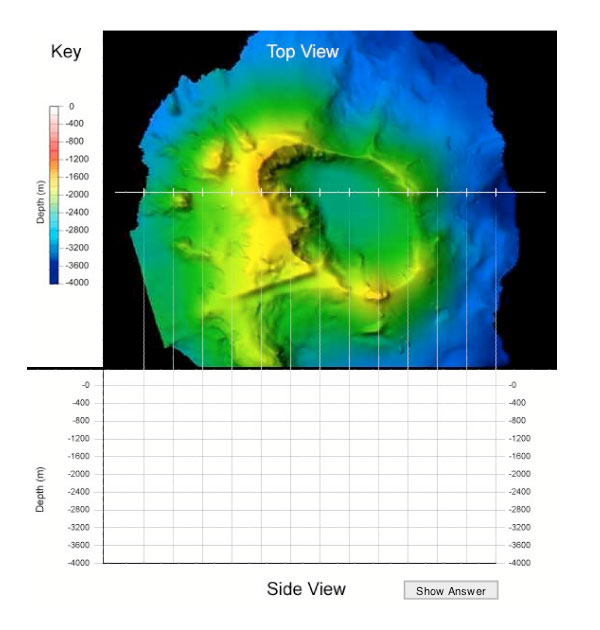
- What are the deepest and shallowest points shown on the image?
[Check Answer]
The deepest point is 4,000 meters below sea level, and the shallowest spot is about 1,400 meters down.
- Briefly describe the structure shown on the image.
[Check Answer]
It is a steep-sided mountain with a large depression in the center.
- Based on its topography and location in the Mariana area, what do you think this structure is?
[Check Answer]
The structure is an undersea volcano with an asymmetrical central crater.
- Which side of a subduction zone did this structure form upon?
[Check Answer]
Volcanoes form on the plate that isn’t subducted, so this volcano is on the less dense over-riding plate.
Related Links
Multimedia Discovery Missions: Lesson 4 - Subduction Zones