1922
The USS Stewart runs a line of soundings across the Atlantic Ocean using an acoustic echo sounder devised by Dr. Harvey Hayes, a U.S. Navy scientist. The French also run an acoustic sounding line from Marseilles to Phillipeville, Algeria, for a submarine cable survey.

The USS Stewart made approximately 900 soundings, from the United States to the Straits of Gibralter, with the Hayes echo sounder. Image courtesy of the NOAA Photo Library. Download larger version (jpg, 56 KB).
1923
The Coast and Geodetic Survey Ship Guide is equipped with a Hayes sounding instrument. Over the next five years, virtually all Coast Survey ships are equipped with deep-water acoustic sounding instruments.
1924
The Coast and Geodetic Survey conducts the first RAR (radio acoustic ranging) navigation operations on the U.S. West Coast. This is the first navigation system capable of round-the-clock operation in all weather conditions and does not require a navigator to see either some recognizable landmark or celestial object to position a vessel. It is a major step on the road to modern electronic navigation systems, oceanic seismic refraction and reflection profiling, and the development of telemetering oceanographic instruments.

Coast and Geodetic Survey scientist Captain Nicholas Heck developed radio acoustic ranging (RAR) in 1923 and 1924. This is a diagram of the radio acoustic ranging concept. Image courtesy of the NOAA Photo Library. Download larger version (jpg, 76 KB).
1925-1927
The German Meteor expedition systematically surveys the South Atlantic with echo-sounding equipment and other oceanographic instruments, proving beyond a doubt the continuity of the Mid-Atlantic Ridge.
RAR leads to advances in the understanding of sound in seawater and provides a first glimpse of the potential for transmitting sound throughout oceanic basins. By 1925, observations have been made over a distance of 206 miles.

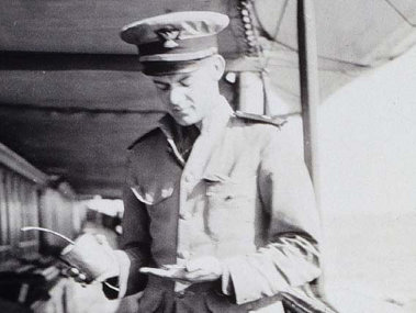
An officer times the fuse on a quart bomb during RAR operations. TNT bombs were used as a sound source for RAR. Image courtesy of the NOAA Photo Library. Download larger version (jpg, 43 KB).
1925-1939
The Coast and Geodetic Survey conducts systematic tracklines across the Gulf of Alaska, discovering numerous seamounts, including the flat-topped variety that Dr. Harry Hess later terms guyots. Systematic Coast and Geodetic surveys of the continental shelf and slope lead to the discovery of the Mendocino Escarpment, which H.W. Menard later shows to be part of a great system of Pacific fracture zones; delineation of the basin and range topography of Southern California's continental borderlands; the discovery of California seamounts such as Davidson, Pioneer, and Guide; and the discovery of many East Coast canyons, particularly in the Georges Bank and Mid-Atlantic areas.

Profiles of submarine mountains discovered in the Gulf of Alaska by systematic Coast and Geodetic Survey tracklines between 1925 and 1939. The flat-topped seamounts are the prototype 'guyots' described by Dr. Harry Hess of Princeton a few years later. Image courtesy of the NOAA Photo Library. Download larger version (jpg, 52 KB).
1930
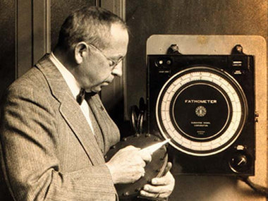
Herbert Grove Dorsey is a principal scientist during the development of echo-sounding devices called fathometers.

Herbert Grove Dorsey with the Dorsey Fathometer around 1930. Image courtesy of the NOAA Photo Library. Download larger version (jpg, 69 KB).
1933
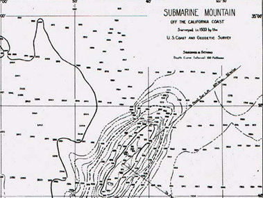
The Coast and Geodetic Survey ship Guide discovers a "submarine mountain" in 1933. In 1936, the "mountain" is officially designated Davidson Seamount in honor of George Davidson of the Survey. This is the first feature to ever be termed a "seamount."

Davidson Seamount. Image courtesy of the NOAA Photo Library. Download larger version (jpg, 85 KB).
1934
Edward Beebe is lowered in a tethered bathyscaph to a depth of 3,028 feet, marking the advent of manned exploration of the sea.
1935
Researchers at the Coast and Geodetic Survey invent an automatic telemetering radio sono-buoy. This instrument eliminates the need for manned station ships during RAR navigation operations. This is, perhaps, the first offshore moored telemetering instrument.
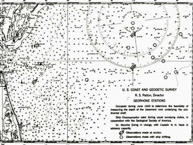
Dr. Maurice Ewing, the "father of marine geophysics," conducts the first offshore seismic reflection experiment on board the Coast and Geodetic Survey Ship Oceangrapher.

This map shows the location of seismic reflection experiments conducted by Maurice Ewing aboard the Coast and Geodetic Survey Ship Oceanographer in 1935. Image courtesy of the NOAA Photo Library. Download larger version (jpg, 80 KB).
1937
Athelstan Spilhaus invents the bathythermograph, a continuously recording temperature measurement device. The invention's name stands the test of time and is still in use today.
1938
Lieutenant Elliott B. Roberts, of the Coast and Geodetic Survey, develops the Roberts Radio Current Meter. This instrument is possibly the first automatic moored telemetering instrument to measure a physical oceanographic parameter.
1941-1945
During World War II, electronic navigation systems are developed for precision bombing, including the gee system, which Coast and Geodetic Survey hydrographers adapt and rename Shoran. In 1945, the Survey conducts its first hydrographic surveys using Shoran. Other inventions from this period pertinent to ocean exploration include deep-ocean camera systems, early magnetometers, sidescan sonar instruments, and early technology for guiding remotely operated vehicles.

Navigation lattice generated by Shoran transmitting stations in the western Aleutian Islands in 1945. This was the first experimental use of a purely electronic navigation system by the Coast and Geodetic Survey and was an outgrowth of World War II aerial navigation developments. Image courtesy of the NOAA Photo Library. Download larger version (jpg, 67 KB).