NOAA Ocean Exploration 2024 Expeditions
NOAA Ocean Exploration works with partners to explore previously unknown areas of our ocean, making discoveries of scientific, economic, and cultural value and supporting innovations in exploration tools and capabilities. In 2024, projects will take place in the North and South Pacific oceans and in deepwater areas around Puerto Rico and the U.S. Virgin Islands. Read on to learn more about what we have planned for this year and check back often as we add summaries highlighting major accomplishments and other content from each project.
Dates are subject to change.
Legend
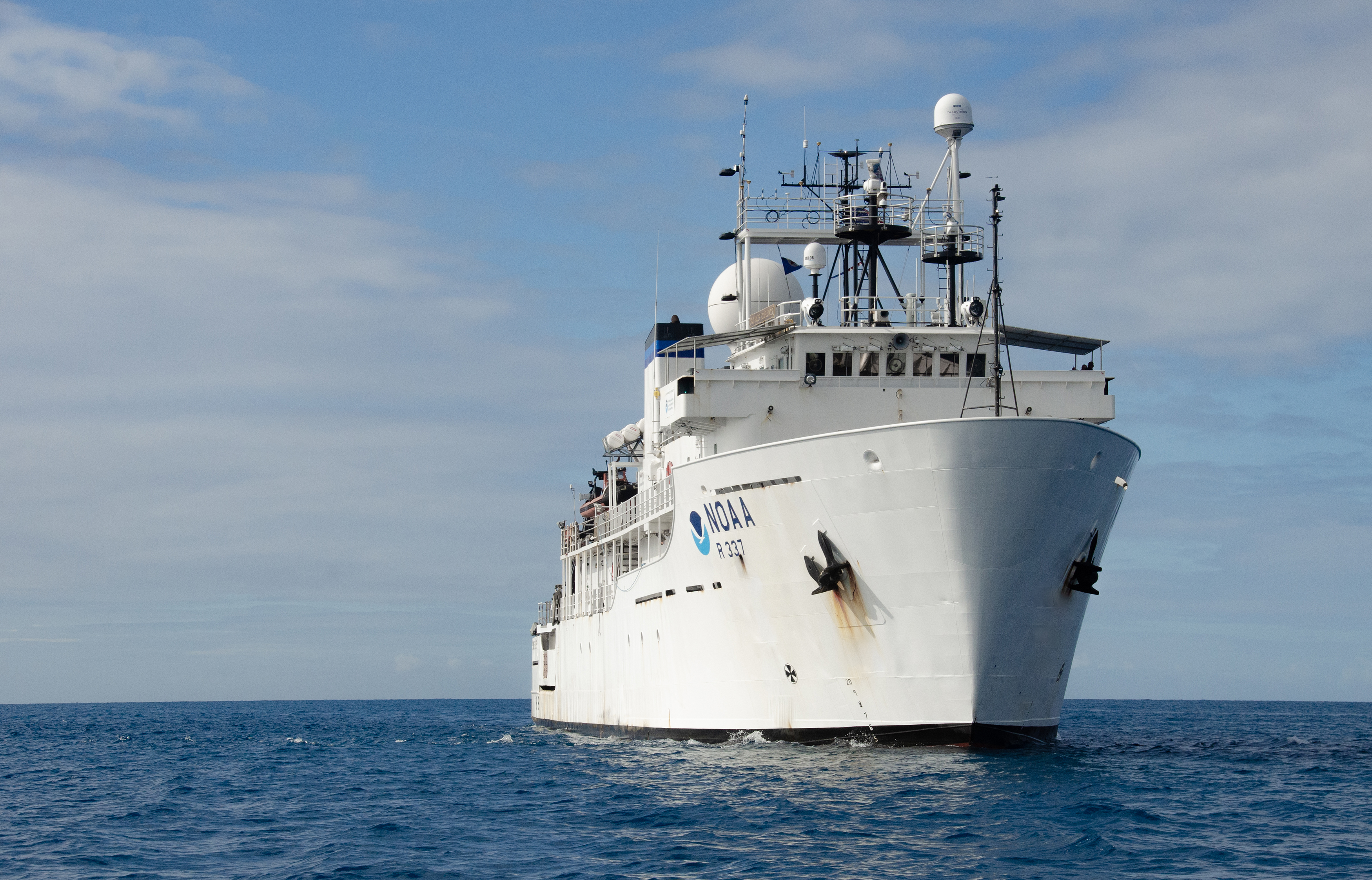
NOAA Ocean Exploration conducts ocean exploration expeditions on NOAA Ship Okeanos Explorer, the only federal vessel dedicated to exploring our largely unknown ocean for the purpose of discovery and the advancement of knowledge about the deep ocean.
NOAA Ocean Exploration provides support to the NOAA Ocean Exploration Cooperative Institute to explore, map, and characterize the nation’s vast ocean territory, to develop and implement new technologies, and to engage future generations of ocean scientists, engineers, and stakeholders.
NOAA Ocean Exploration manages an annual ocean exploration competitive grant program to catalyze the ocean exploration community and advance ocean knowledge across three categories: ocean exploration, technology, and maritime heritage.
This expedition is expected to feature live video.
Expeditions led or supported by NOAA Ocean Exploration in 2024 are described below; click on a title to expand the text and learn more about an individual expedition.
April-May 2024
After an extended repair period in California, NOAA Ship Okeanos Explorer will transit to Honolulu, Hawai‘i, in April to begin 2024 exploration efforts. While underway, the team will spend time calibrating, testing, assessing, and adjusting the ship’s acoustic mapping systems and associated equipment. This “shakedown" is important to ensuring that mapping systems on Okeanos Explorer are tuned and ready for a full season of exploration and discovery, particularly after a significant period of inactivity. The shakedown component of the expedition also provides time to perform safety drills and routine maintenance on major equipment, including main engines, stern and bow thrusters, dynamic positioning system, fast rescue boats, cranes, and even galley equipment like refrigerators and ovens. Once all testing objectives are complete, mapping operations will focus on the collection of bathymetric, sub-bottom, and water column data within waters of the U.S. Exclusive Economic Zone surrounding the Hawaiian Islands. These data may reveal new discoveries and targets for future exploration.
Learn more
April 13-22, 2024
Principal Investigator: Esther A. Guzman, Florida Atlantic University
Natural products produced by animals, plants, and microbes on land have long been used as sources of drugs and treatments for human illnesses and diseases. Marine natural products are also potential sources for such drugs and treatments. And now, they are having a growing impact in the field of biotechnology, and biopharmaceuticals in particular. While the potential of marine natural products may be great, access to them for preclinical and clinical investigations is not. This research team will explore and document marine habitats in deepwater areas around Puerto Rico and the U.S. Virgin Islands with the goal of collecting marine organisms (e.g., sponges, corals, and microorganisms) that may contain natural products that can be developed into useful pharmaceutical products. Collected samples and subsamples will be stored in and shared via a suite of long-term repositories that will enable future biopharmaceutical research and development. Knowledge gained during and as a result of this work will contribute to the treatment and prevention of existing and emerging illnesses and diseases.
May-November 2024
Beyond the Blue: Illuminating the Pacific is a multiyear, multipartner cooperative research campaign to continue to address high-priority ocean exploration gaps in the Pacific Islands region. As some of the most remote and least explored areas on Earth, this campaign will provide timely, actionable information to support decision-making based on reliable and authoritative science. It also serves as an opportunity to highlight the uniqueness and importance of these areas. In 2024, the first year of the campaign, NOAA Ocean Exploration will lead six mapping expeditions on NOAA Ship Okeanos Explorer around Hawai‘i and Johnston Atoll in support of the Beyond the Blue campaign.
Learn more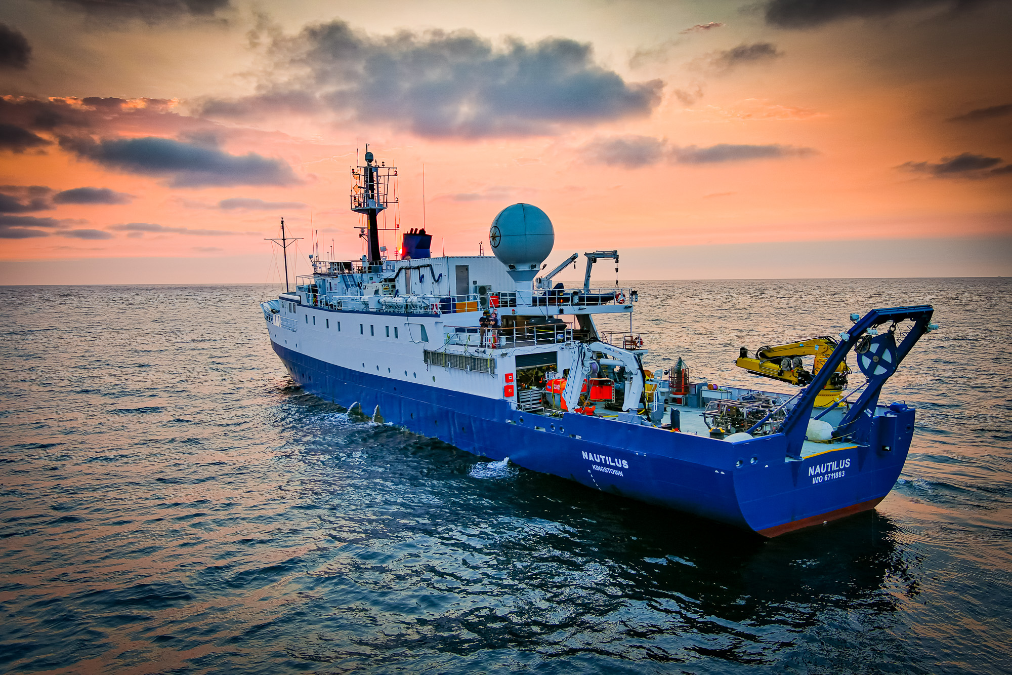
May-November 2024
Live Video
NOAA Ocean Exploration supports Exploration Vessel Nautilus via the NOAA Ocean Exploration Cooperative Institute, working with Ocean Exploration Trust to reduce uncertainties in critical parts of our largely unexplored deep ocean and advance marine technologies. In 2024, between May and November, Nautilus will be used to map unsurveyed seafloor, and characterize deep-sea habitats in the central and western Pacific. Information about the 2024 season on Nautilus is on Nautilus Live, where live video from remotely operated vehicle dives will be streamed for public viewing.
Learn more
May 12-22, 2024
Principal Investigator: Russ Hopcroft, University of Alaska, Fairbanks
The northern Gulf of Alaska is a region of high productivity and supports some of the nation’s largest commercial fisheries. But, ocean warming and deoxygenation are raising concerns about the future of the region’s poorly understood deep waters and the fish and invertebrates that live there. This research team has devised a novel, multipronged exploration program to investigate the diversity and distribution of these deep-ocean animals. Building on previous work, their program includes acoustic, photographic, video, and physical and molecular (DNA) inventories of the small animals (zooplankton and micronekton), like fish, crustaceans, gelatinous animals, and squid, in the water column. Special attention will be given to how seamounts and changing biomass of gelatinous animals (due to a warming ocean) impact water column communities. By integrating state-of-the-art acoustic sensing and sampling methods, including a towed imaging system, this project will add to our understanding of the ecology of the northern Gulf of Alaska, the connections between its shelf and ocean habitats, and its response to changing conditions. It will also help us better manage the important resources provided by the region.
May 16-June 7, 2024
Principal Investigator: Timothy Shank, Woods Hole Oceanographic Institution
The seafloor of the Aleutian margin hosts exotic ecosystems, including methane seeps and deepwater corals, and may also hold critical minerals. Given the importance of these natural resources, the U.S. government identified the U.S. Exclusive Economic Zone around Alaska’s Aleutian Islands as a priority for exploration and characterization. Little is known about the diverse ecosystems in these waters, so the potential for scientific discoveries is high, and the need for science to support knowledge-based policies is pressing. To further our understanding of this important region, this team will use cutting-edge tools and approaches, including two autonomous underwater vehicles with imaging and sampling capabilities (including a newly developed deep-sea methane sensor) to geologically, chemically, and biologically map the water column and seafloor along the eastern Aleutian margin. They anticipate discovering new seeps; chemosynthetic, coral, and sponge communities; seafloor minerals; and more. These findings will advance knowledge of the fundamental geological and biological features of the Aleutian margin, direct and inspire further exploration and research, and inform decision-making at the regional and national levels.
July 2024
Principal Investigator: Jason Raupp, East Carolina University
Attu in Alaska’s Aleutian Islands is the site of the only World War II (WWII) battle fought on North American soil. In 2019, the Attu Battlefield and associated airfields were incorporated into the Aleutian Islands WWII National Monument. Nevertheless, few people know about the battle, the larger campaign, or their significance to the nation, and Attu’s underwater battlefield is completely undocumented. To bring attention to this chapter in U.S. history, this research team will inventory Attu’s maritime heritage sites. To do so, they will use an innovative synthetic aperture sonar system both towed behind a research vessel and deployed on an uncrewed underwater vehicle to map the seafloor and detect targets. A remotely operated vehicle will be used to capture follow-up video and still photographs. In addition to discovering and documenting WWII maritime heritage sites, this team also seeks to answer questions about Attu’s pre-war maritime history and hire Alaska Native consultants to contribute to our understanding of Attu’s marine environment and the Aleut population displaced by the U.S. government during the war. Finally, this work will provide a foundation for further work to locate missing in action U.S. and Japanese service personnel.
July 23-31, 2024 (Second of two expeditions)
Principal Investigator: Craig McNeil, University of Washington
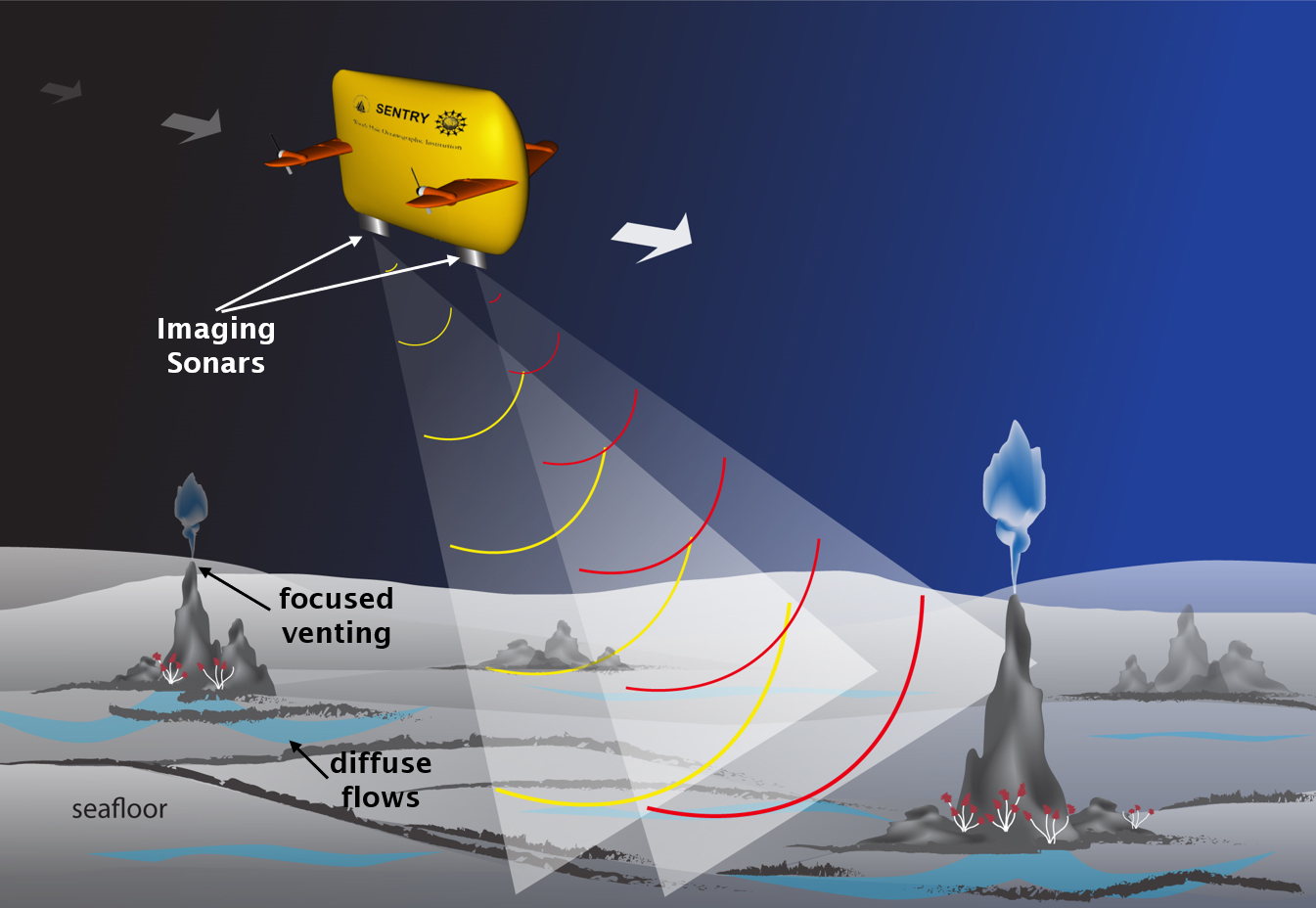
Methane is a potent greenhouse gas, and it’s released into the ocean from the seafloor as gas bubbles via methane seeps. Despite the prevalence of seeps along continental margins, data is limited, and their impacts on the ocean and atmosphere, both positive and negative, are poorly understood. To advance our knowledge about methane seeps, this research team will develop and demonstrate an approach to efficiently and effectively map and characterize methane seeps over wide areas. This approach will use easily deployable and relatively inexpensive autonomous underwater vehicles equipped with imaging sonars and custom sensors to find and map seeps and measure associated bubbles and dissolved methane right at the source and up through the water column. The team will demonstrate their approach at known seep sites off Oregon/Washington with the goal of improving our understanding of how methane from these seeps influences life on the seafloor and in the water column as well as its role in the global carbon cycle.
Learn more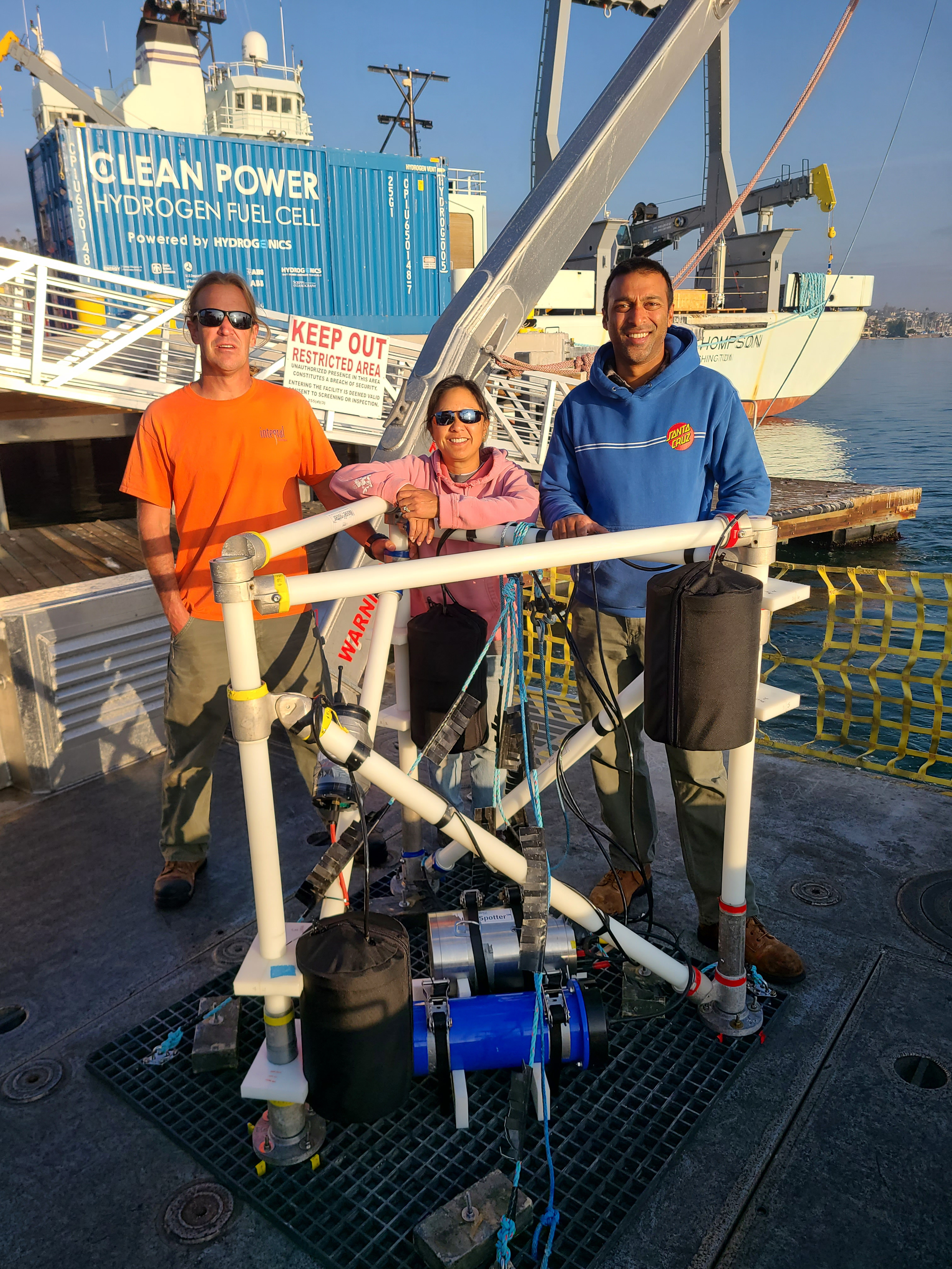
July/August 2024
Principal Investigator: Kaustubha Raghukumar, Integral Consulting Inc.
Sound is a crucial component of ocean science and stewardship. Deepwater soundscapes can provide insight into marine mammal distributions, seismic and volcanic activity, illegal fishing activity, other human activities, and more. Yet, collecting acoustic data in the deepest and most remote parts of our ocean has historically been difficult, largely due to the challenges of deploying and recovering traditional acoustic sensing equipment in these hard-to-reach places. To advance deepwater soundscape exploration, this research team will develop and demonstrate the first ever first autonomous, near-real-time, directional acoustic profiling float powered by marine renewable energy (ocean thermal energy conversion, OTEC). They will also develop soundscape analysis tools to provide insights into acoustic events of interest recorded by the float. The portable and low-cost float will enable sustained exploration of poorly understood deepwater soundscapes, eventually increasing the amount of global soundscape data — data that will expand the breadth of our deep-ocean knowledge, support biological and hazards monitoring, and inform management and mitigation of ocean noise to eliminate or reduce impacts on marine life.
August 10-28, 2024
Principal Investigator: Guangyu Xu, University of Washington
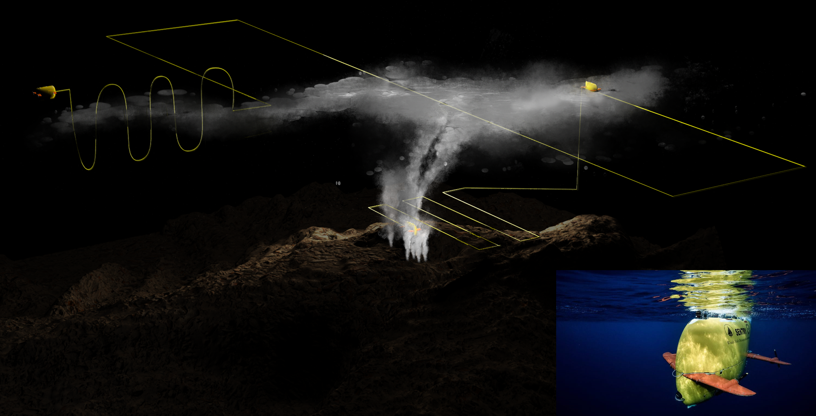
Some of Earth’s most unique habitats exist on the seafloor at sources of fluid discharge such as hydrothermal vents and cold seeps. The importance of these systems has been recognized for decades, and improvements have been made in the tools we use to search for them, such as autonomous underwater vehicles (AUVs). Nevertheless, the methods used for such exploration remain crude, and the reliance on human supervision hinders discovery. To streamline the process of locating seafloor fluid flow sites, this research team will develop a fully autonomous algorithm to enable AUVs to trace biogeochemistry signatures in the water column that are indicative of vents and seeps using real-time data recorded by onboard sensors, independent of human operators. After robust testing, they will demonstrate their approach at an active hydrothermal vent site near American Samoa. This new approach will improve the efficiency of AUV-based exploration and enhance the ability of scientists to conduct other operations at the same time while at sea. Ultimately, it has the potential to improve our knowledge about seafloor vents and seeps and the marine life they support.
October 2024 (Second of two expeditions)
Principal Investigator: Matthew Johnson-Roberson, Carnegie Mellon University
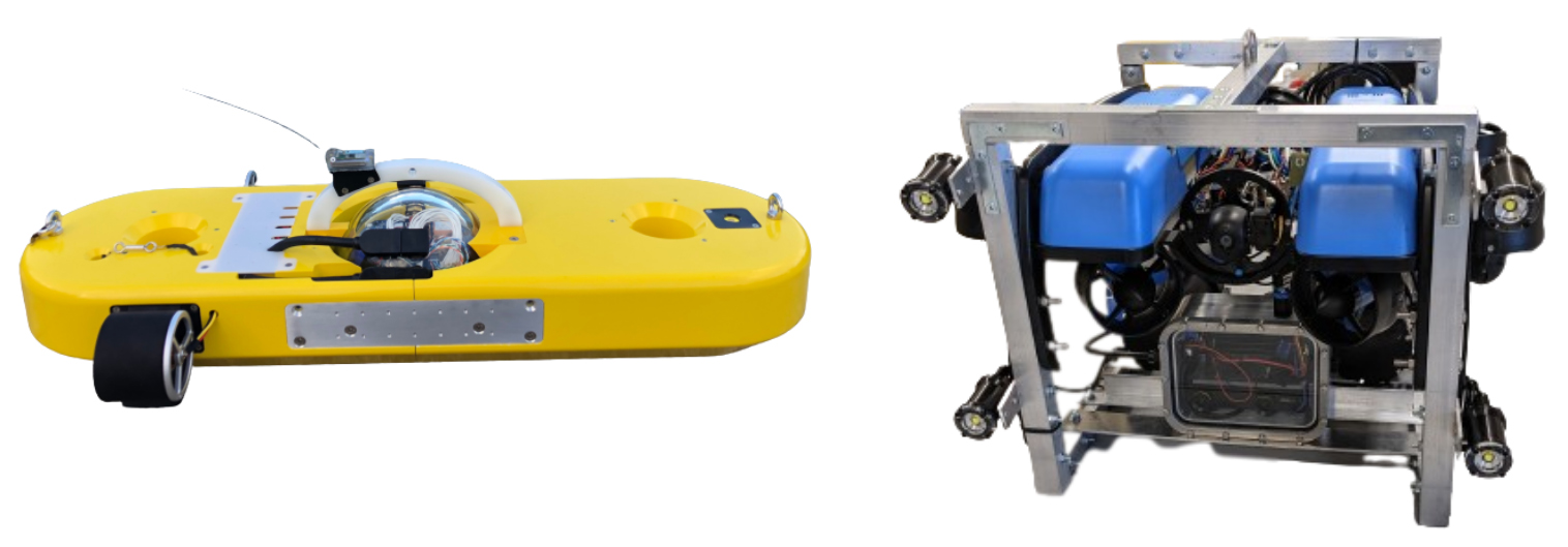
Deep-sea corals provide habitat for a wide variety of marine life. Despite their importance to the environment, little is known about them and the threats to their survival. Deep-sea data collection is expensive, and annotation and analysis of underwater imagery is time consuming. To help advance the protection of deep-sea coral ecosystems, this team will improve and validate new, low-cost, open-source, autonomous underwater vehicles (AUVs) and develop automatic annotation software. They will test the AUVs and collect data at a site in Hawaiian waters that is known for its high diversity and density of corals. Data collected will be used to generate photometric 3D reconstructions of the seafloor and for the development of the software. This project will benefit the scientific community in two key ways: It will make deep-sea exploration more accessible to the larger scientific community and will increase the speed of data analysis and availability.
Learn more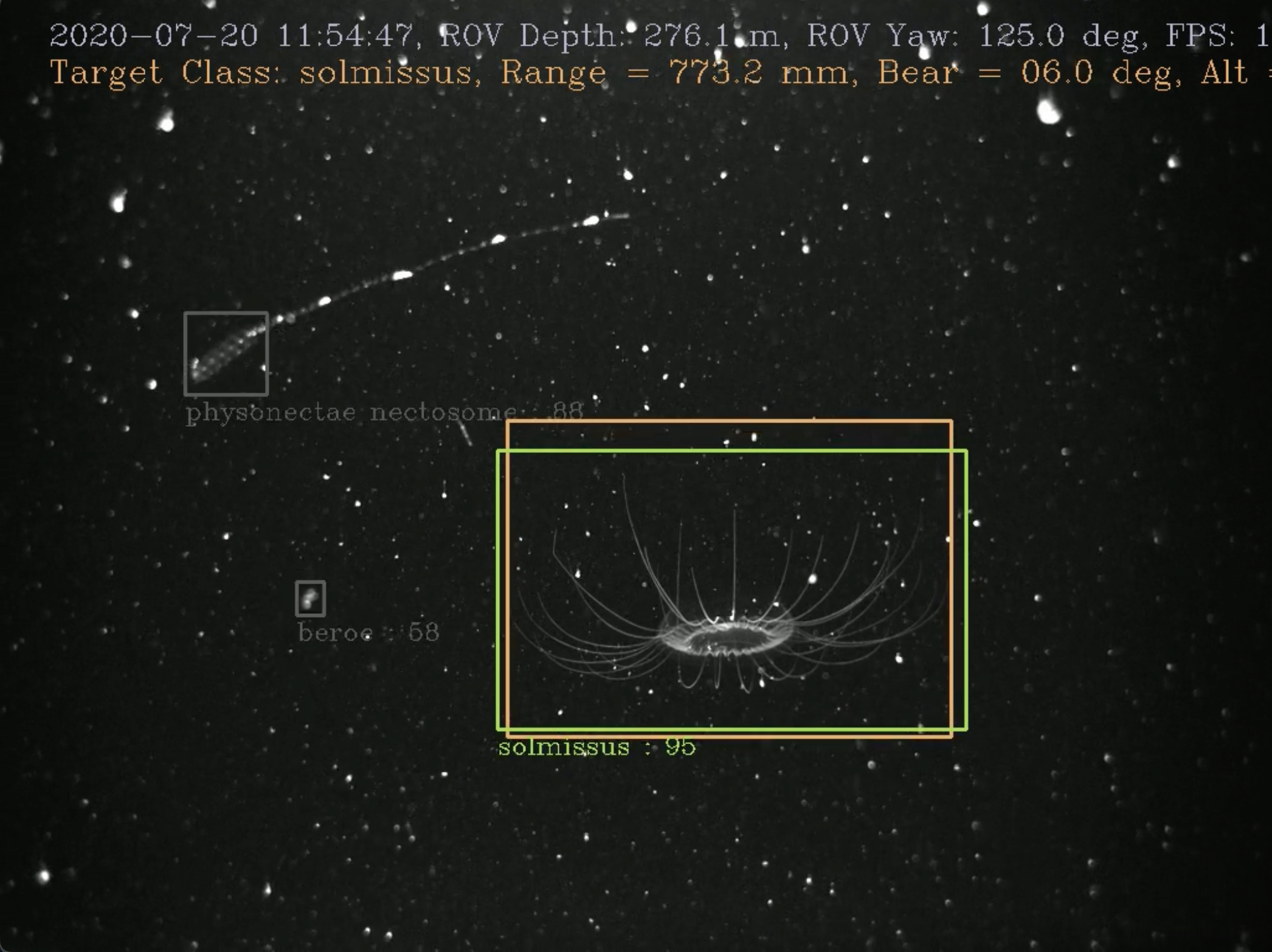
Throughout 2024
Principal Investigator: Kakani Katija (Young), MBARI (Monterey Bay Aquarium Research Institute)
We still have much to learn about our ocean and the animals that live within it. Modern robotics, low-cost observation platforms, and other emerging exploration tools are making underwater imaging easier and more accessible. However, processing all this visual data, particularly data with complex scenes and animals that require expert classifications, is quite resource intensive. This research team will use artificial intelligence (AI) to address this significant obstacle to discovery. Specifically, they will develop software for remotely operated and autonomous underwater vehicles to detect, track, and classify seafloor and water column animals in underwater video in real time. They will train this “deployable AI” using FathomNet, a publicly available underwater image training set, which they will expand and augment as part of this project, and test it in the waters of Monterey Bay National Marine Sanctuary. By automating the collection and real-time analysis of large volumes of underwater visual data by uncrewed underwater vehicles and making the imagery available in a global database, this project will enable scientists, policymakers, and the public to better, and more rapidly, understand the life that inhabits our ocean.
2024
Principal Investigator: Guangyu Xu, University of Washington
Hydrothermal vents often feature a variety of unique biological communities and metal-rich deposits, making them important to society and economies. However, most hydrothermal vent sites discovered to date are on the deep-ocean floor at great depths below the sea surface. Because of the inherent difficulties of deep-sea exploration and the inadequacy of existing vent-characterization techniques, the majority of the known hydrothermal-vent fields remain poorly studied and many sites are yet to be discovered. To advance our knowledge about hydrothermal vents, this research team will develop an innovative approach to identifying, locating, and characterizing hydrothermal discharge using an autonomous underwater vehicle (AUV) equipped with coordinated multibeam sonars. After a robust evaluation program, which will include computer simulations and laboratory experiments at an engineering tank facility, the new approach will be demonstrated at an active hydrothermal vent site. Anticipated outputs include seafloor bathymetry, 3D acoustic plume images, quantitative vent maps, and 3D panoramic images of vent sites. By extending the capabilities of AUVs, this project will deliver an efficient approach to collecting comprehensive baseline data about hydrothermal activity needed by researchers and policy makers.
Last updated April 29, 2024
Published April 4, 2024