
By Kasey Cantwell, NOAA Office of Ocean Exploration and Research
Shirley Pomponi, Harbor Branch Oceanographic Institute at Florida Atlantic University
Patty Fryer, University of Hawaii at Manoa
Derek Sowers, NOAA Office of Ocean Exploration and Research
July 12, 2016
Deep-sea corals and sponges provide habitat for other organisms to live on, creating oases of life. During missions such as the 2016 Deepwater Exploration of the Marianas expedition, scientists are able to survey areas that have never been seen before, gaining glimpses into potential "hotspots of diversity." Information about these habitats can in turn help resource managers better manage and protect our ocean resources. Video courtesy of NOAA Office of Ocean Exploration and Research, 2016 Deepwater Exploration of the Marianas. Download (mp4, 388.3 MB).
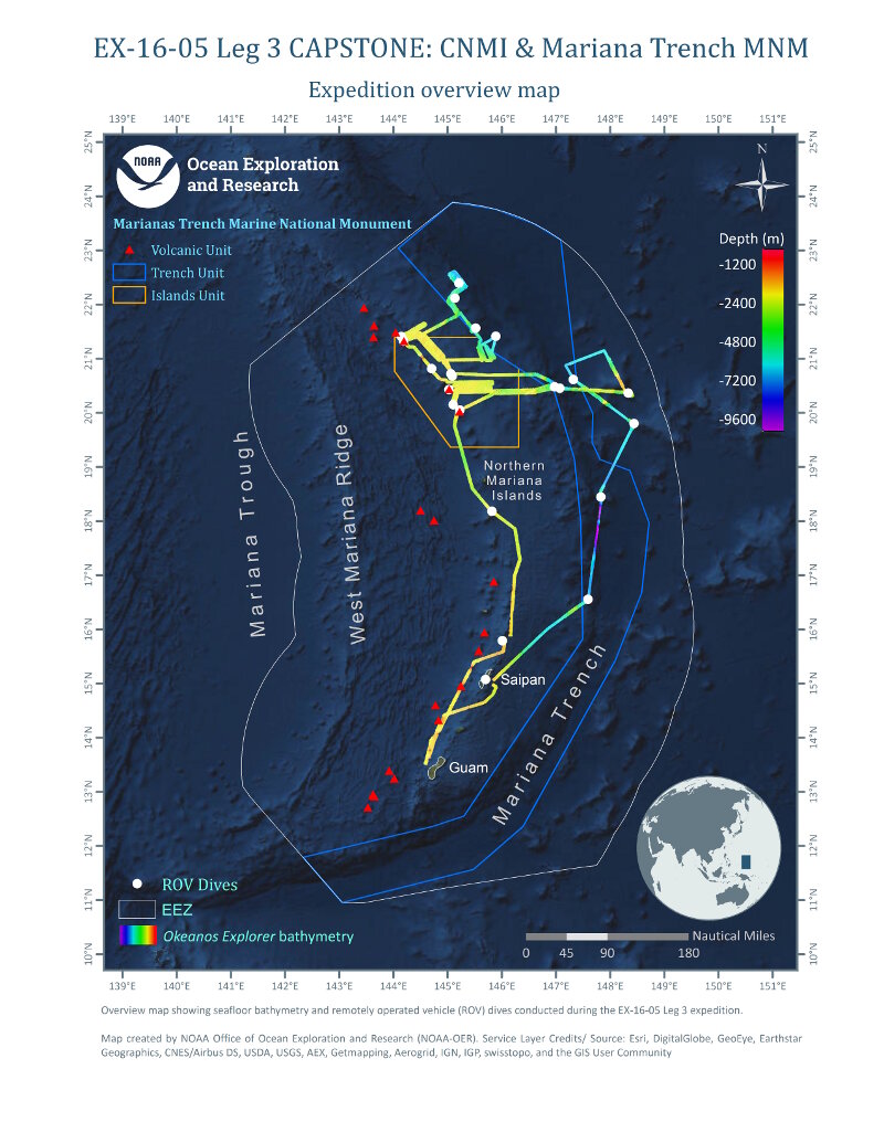
With 22 remotely operated vehicle (ROV) dives and mapping over 27,700 square kilometers of seafloor, Leg 3 of the 2016 Deepwater Exploration of the Marianas covered a lot of ground! Here ROV dives are noted in white, with the ship’s track displayed as the multibeam bathymetry collected. The U.S. Exclusive Economic Zone is outlined in grey and the blue and orange lines represent the borders of the Trench and Island Units, respectively, of the Marinas Trench Marine National Monument. The red triangles represent the Volcanic Units of the Monument. Image courtesy of the NOAA Office of Ocean Exploration and Research. Download larger version (jpg, 8.6 MB).
After a successful third leg, the 2016 Deepwater Exploration of the Marianas Expedition has been completed! NOAA Ship Okeanos Explorer returned to Guam on July 10, 2016, after completing 22 remotely operated vehicle (ROV) dives and over 270 hours (the equivalent of 11 days) of dedicated mapping operations to collect baseline information in unknown and poorly understood areas in and around the Marianas Trench Marine National Monument and the Commonwealth of the Northern Marianas Islands.
We observed hundreds of different species of animals during the leg. There were dozens of potential new species, as well as an abundance of new records for the region and several significant range extensions. Many organisms were also seen alive for the first time!
One of the priorities identified for the entire expedition was to survey deep-sea coral and sponge habitats. This expedition was the first ever to specifically focus on identifying and documenting these habitats in the deep waters of the Marianas. Four new high-density communities were documented at Vogt Seamount, Maug, Explorer Ridge, and Farallon De Medinilla. We also confirmed the presence of precious corals in the northern portion of the Monument, surveyed deepwater bottomfish fishery habitats, and expanded the known depth range for bamboo corals by approximately 100 meters.
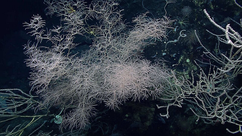
The deep-sea corals on Vogt Seamount were amazing! This seamount hosted the most diverse and dense community of deep-sea coral and sponges of the entire cruise. In this image alone, there are over 12 individual colonies, some of which are quite large! Image courtesy of the NOAA Office of Ocean Exploration and Research. Download larger version (jpg, 1.2 MB).
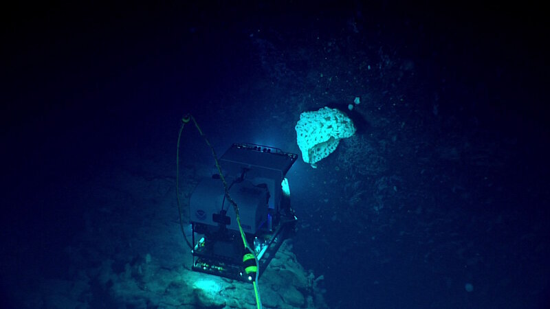
Some of the corals and sponges on Vogt Seamount were very large, indicating a healthy and stable community. Here, ROV Deep Discoverer images a sponge that was over a meter across. This was only one of several organisms seen throughout the dive that were this size. Image courtesy of the NOAA Office of Ocean Exploration and Research. Download larger version (jpg, 482 KB).
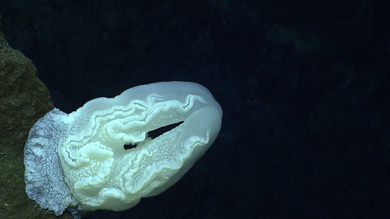
One of the unusual benthic platyctenid ctenophores documented during Dive 5 at Ahyi Seamount. Image courtesy of the NOAA Office of Ocean Exploration and Research. Download larger version (jpg, 511 KB).
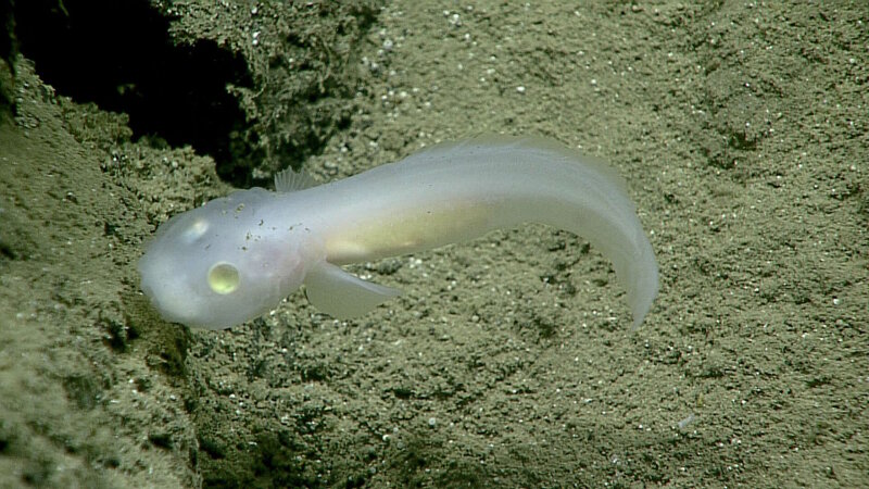
This fish, of the family Aphyonidae, had never before been seen alive. In situ observations like this are critical to understanding an organism’s life and we now have the first evidence of where these fish live! Image courtesy of the NOAA Office of Ocean Exploration and Research. Download larger version (jpg, 1.0 MB).
Another focus of the leg was to explore submarine volcanic habitats. We documented new vents in the caldera of Daikoku Seamount and Eifuku Seamount as well as an entirely new vent field at Chamorro Seamount - an area with no known history of eruptions! We also discovered a new mud volcano at a site that was mapped for the first time during Leg 2 of this expedition.
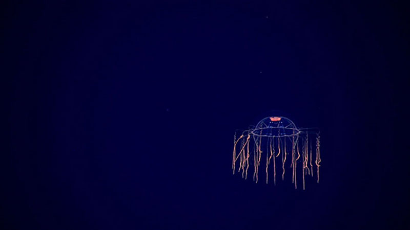
This unidentified jellyfish was spotted during our water column exploration on Dive 18 at a petit-spot volcano. Image courtesy of the NOAA Office of Ocean Exploration and Research. Download larger version (jpg, 241 KB).
One of the most exciting geologic finds of Leg 3 was the discovery of the first ever petit-spot volcano in U.S. waters. This is the first time this type of volcano has been seen in the Marianas as well as anywhere outside of Japan. This is the first evidence that the petit-spot phenomena could be much more widespread than originally hypothesized.
Four of our ROV dives during this leg included midwater transects (350 meters – 4,000 meters) to collect critical information in this largely unknown biome. The majority of organisms identified during these transects were new records for the Marianas, rare observations, and potential new species. As far as we know, our 4,000-meter mid-water transect was the deepest water column exploration that has ever been completed!
On our final dive, we discovered a World War II B-29 Bomber in the channel between Tinian and Saipan. This was the first discovered of a collection of a dozen American B-29s lost in the area while flying missions against Japan in World War II. The sites represent the final stages of the war, an historically significant time in American history, and are of interest to the Department of Defense POW/MIA Accounting Agency, Saipan Historic Preservation Office, National Park Service, U.S. Navy, U.S Air Force, and several universities and foundations working to identify crash sites for the families of lost servicemen.
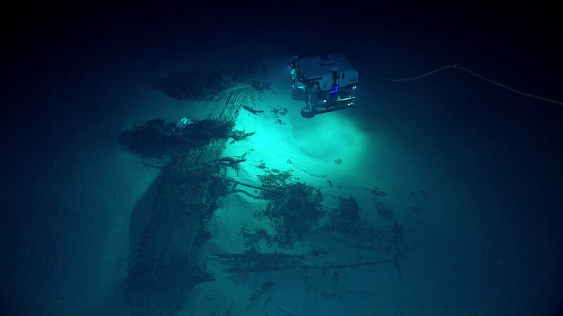
ROV Deep Discoverer discovers a B-29 Superfortress resting upsidedown on the seafloor. This is the first B-29 crash site found of over a dozen American B-29s lost in the area while flying missions during World War II. Image courtesy of NOAA Office of Ocean Exploration and Research, 2016 Deepwater Exploration of the Marianas. Download larger version (jpg, 551 KB).
During Dive 9, we explored Daikoku Seamount, observing active venting and thick volcanic smoke, supporting the hypothesis that there had been recent volcanic activity in the area. Plumes of likely carbon dioxide gas and sulfur were emanating from cracks and orifices near the crater rim and along the lower wall of the crater. This was likely the plume that we saw during mapping operations. Video courtesy of NOAA Office of Ocean Exploration and Research, 2016 Deepwater Exploration of the Marianas. Download (mp4, 72.3 MB).
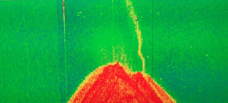
During mapping operations, our multibeam system also collects water column backscatter or data about what is in the water column between the surface and the seafloor. When mapping Daikoku Seamount, we found a very active hydrothermal plume that eventually helped us target the ROV dive transect. We believe that this plume was composed of the large amounts of bubbles coming from the seafloor that we saw during the ROV dive. Image courtesy of the NOAA Office of Ocean Exploration and Research. Download larger version (jpg, 1.7 MB).
As with every Okeanos mission, mapping operations were conducted whenever the ROV was secured on deck. While mapping, we focused on building off of the Leg 2 dataset, in areas prioritized by managers, and in areas that had never been mapped with a multibeam system. Throughout the cruise, we mapped over 27,700 square kilometers of seafloor – an area a little bigger than Massachusetts – revealing new ridge features and an active hydrothermal plume over Daikoku Seamount.
One of the most exciting parts of telepresence-enabled operations is that we are able to build a practically unlimited science team to greatly expand the breadth of experience that we have access to during a cruise. During Leg 3, 78 scientists and students from all over the U.S. mainland, Hawaii, Guam, Commonwealth of the Northern Mariana Islands, Russia, Canada, Spain, and Japan participated in the expedition. This is the largest science team we have ever had participating in a cruise and a team that is much larger than could ever fit on a single research vessel!
Beyond our science team, the 2016 Deepwater Exploration of the Marianas expedition continued to hold the interest of the public, as we received an additional 530,000+ views of the live video feeds, bringing the expedition total to over 3.1 million views. We also received coverage by over 50 media outlets, which coupled with the high viewership, stand as a testament to the public’s interest in learning more about the deep sea and passion for exploration.
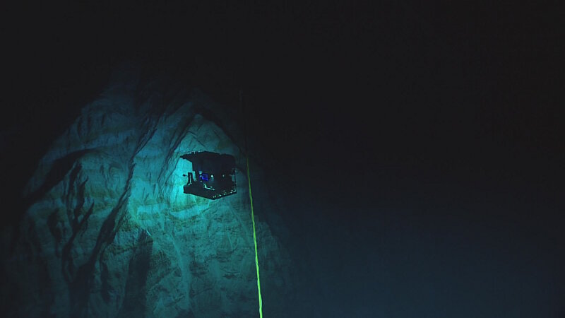
View of ROV Deep Discoverer exploring at the depth of 6,000 meters in the Mariana Trench. Never-before-seen geological features reminiscent of the Alps and canyons in California stunned participating scientists on the ship and on shore. Image courtesy of the NOAA Office of Ocean Exploration and Research. Download larger version (jpg, 345 KB).
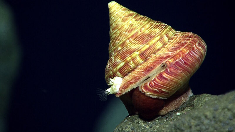
An exciting discovery during our dive at Pagan – this slit shell snail was a new observation for the Marianas and likely a new species! Image courtesy of the NOAA Office of Ocean Exploration and Research. Download larger version (jpg, 616 KB).
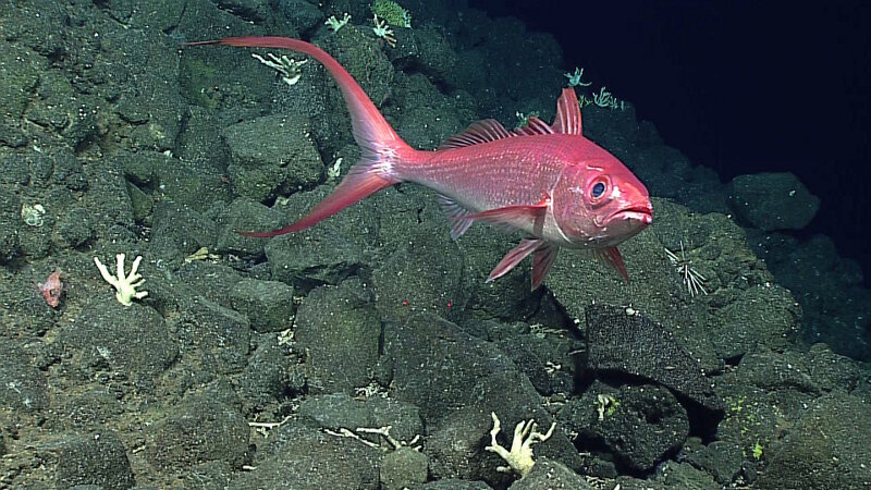
This Long-Tail Red Snapper was spotted during Dive 2 on Pagan. In the words of one of our science team members – we were exploring for bottom fish, and this one was the "primo" find! Image courtesy of the NOAA Office of Ocean Exploration and Research. Download larger version (jpg, 1.1 MB).
This was one of the longest ROV missions Okeanos has ever undertaken, but the value of the work completed over the last 22 days and over the last several months is unquestionable. The three legs 2016 Deepwater Exploration of the Marianas Expedition has left the region with a legacy of new species, previously unknown features, over 73,000 square kilometers of seafloor mapped, and millions of people around the world interested in the deepwater habitats of the area.
Data collected throughout the expedition will soon be publicly available through the National Archives. Our science team will spend the coming months working with data collected to formally identify new species, prepare data for resource manager use, analyze samples, and answer outstanding questions from the expedition.
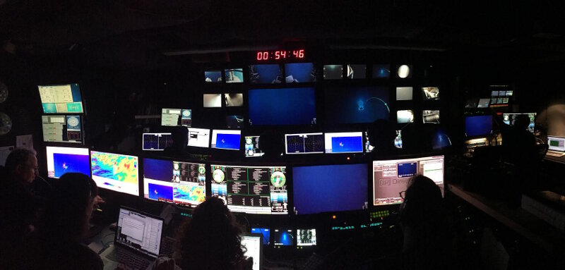
The control room during Dive 4 at Hadal Wall as ROV Deep Discoverer approached 6,000 meters for the first time since Puerto Rico. All systems passed their safety checks and Hadal Wall turned out to be our first of several successful 6,000-meter dives. Image courtesy of NOAA Office of Ocean Exploration and Research, 2016 Deepwater Exploration of the Marianas. Download larger version (jpg, 462 KB).