by Christopher Kelley and John Smith, Hawaii Undersea Research Laboratory
The relationship between mapping and deep water diving using submersibles or remotely operated vehicles (ROVs) is the same as the relationship between a brother and sister. They grow up together and depend on each other for context.
How can a brother or sister represent their family without his or her sibling? And how can you interpret what you see during a dive without knowing where you were and what type of feature you were diving on? Likewise, how can you find out what incredible biology is living on the seafloor from a map?
Mapping is a crucial companion to diving and vice versa. For this reason, NOAA Ship Okeanos Explorer, as well as most other ships with deep diving vehicles, are designed and built to do both.
Ideally, however, existing mapping data is available well in advance of diving, so researchers have a chance to study the terrain and select the best dive sites. For really big areas such as the Papahānaumokuākea Marine National Monument (PMNM) enclosing the Northwestern Hawaiian Islands, and the Johnston Atoll Unit of the Pacific Remote Islands Marine National Monument (JAU), it also really helps to know if and where any previous dives have been conducted.
So part of the essential homework required for exploring any area is to review all of the mapping and diving that has already been done. Therefore, we are turning in our homework assignment below in the form of a summary of the history of mapping and deep water diving that has been carried out in these two monuments.
The first mapping in either Papahānaumokuākea Marine National Monument or the Johnston Atoll Unit of the Pacific Remote islands Marine National Monument took place between 1988 and 1991, well before either was a monument, by the U.S. Geological Survey using sidescan sonar.
The so-called Gloria expeditions provided “backscatter” data revealing the hardness and reflectivity of the seafloor, but not its “bathymetry,” or depth characteristics. In other words, Gloria data could tell you where rocky features such as seamounts were rising out of the abyssal sediment (see Figure 1), but could not tell you how deep the seamount bases were or how high their summits reached.

A mosaic of Gloria data for the northern end of PMNM. Note that in this image, lighter color denotes hard seafloor whereas darker color shows softer sediment seafloor. Image courtesy of the U.S. Geological Survey.
Even so, the data from the Gloria expeditions revealed, for the first time, the presence of deep-sea volcanoes, huge landslides, and other fascinating geologic processes in both PMNM and JAU, that even today, 30 years later, are being used by researchers across the globe.
During the next nine years, ships passing through the monuments occasionally obtained “transit mapping data” or did only a few passes using a different type of sonar called multibeam. It wasn’t until the year 2000 before the first dedicated mapping cruises to either monument began with a cruise by the ship Ka‘imikai-O-Kanaloa (KOK).

The UH swath ship, R/V Kilo Moana. Image courtesy of the UH Marine Center Archives. Download larger version (jpg, 1.5 MB).
The KOK is owned and operated by the University of Hawaii’s School of Ocean and Earth Science Technology (SOEST). SOEST’s deep submergence facility, the Hawaii Undersea Research Laboratory (HURL), was using the ship as a platform for deploying its manned submersibles.
On that first cruise and six subsequent expeditions to PMNM, both before and after it became a monument, HURL used the KOK’s Seabeam multibeam sonar to map prospective dive sites at night prior to the dives the next day. In contrast to the backscatter data obtained from the Gloria sidescan sonar, this early model multibeam sonar only provided bathymetry data, which revealed the depths of the seafloor, but not what was rock and what was sediment. However, like the Gloria data, mapping from these cruises proved invaluable to researchers, in this case for planning and executing submersible dives in PMNM in a safe and productive manner.
In 2002, SOEST took delivery of a newly built ship called the Kilo Moana (KM), which had an unusual “swath” design extremely well suited for mapping (Figure 2). The KM had not just one but two multibeam sonars, each with a different frequency to map in either shallow or deep water.
The KM’s maiden shakedown cruise took place that year in PMNM, again, before it was a monument, and had as its objective to map the 100-fathom contours around as many banks and seamounts as possible to improve the accuracy of NOAA nautical charts for the Northwestern Hawaiian Islands. The survey design of circling the islands at a specific depth was not typical of mapping cruises that are more generally designed as a grid, so this cruise became known as the “Donut cruise” (see Figure 3).

"Donut cruise" mapping around St. Rogatien Banks and French Frigate Shoals. Image courtesy of the University of Hawaii HMRG and NOAA PIBHMC. Download larger version (jpg, 820 KB).
Even though it left large unmapped holes throughout the monument, the Donut cruise still provided data that significantly improved the location of banks and therefore navigational safety in the region. It furthermore provided simultaneous bathymetry and backscatter data at much higher resolution than any of the previous mapping efforts.
The Donut cruise was the first major collaboration between University of Hawaii (UH) and NOAA mapping specialists and the data provided an important framework upon which subsequent mapping surveys were built.
In 2003, NOAA’s Pacific Islands Benthic Habitat Mapping Center (PIBHMC) started a multiyear effort to map the shallower portions of the islands and banks (i.e., the donut holes) in PMNM as well around Johnston Atoll, the latter being the first dedicated mapping survey of JAU. PIBHMC used its small boat mapping platform, the Ahi as well as their larger ship, the Hiialakai.
The Ahi has a shallow multibeam sonar suitable for mapping the lagoons and reefs around the banks and islands, whereas the Hiialakai has a mid-range multibeam sonar designed to map the deeper slopes. This effort took place over the course of five years and the data collected filled many of the shallower holes and mapped slopes down to 1,000 meters, thereby providing yet another important and significant contribution toward visualizing the seafloor in both monuments.
Additional swaths of data came in through the years as ships transited through the monuments with their multibeam systems on. However, even though less than half of PMNM and less than 10 percent of the newly expanded JAU had been mapped by 2008, there would be no other dedicated mapping efforts in either monument for six years.
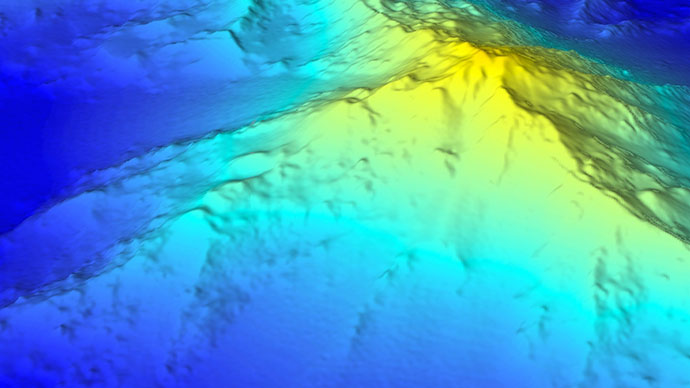
In Spring 2014, the Schmidt Ocean Institute (SOI) and its ship, Falkor, arrived on the scene. With the Falkor as the new platform and SOI providing the lion’s share of the support, UH, PIBHMC, and other NOAA partners pulled together an international team that included the University of Sydney and University of British Columbia. After 72 days of both weather and equipment cooperating, this team acquired 127,000 square kilometers of new mapping data in PMNM, finishing the entire northern half of the monument down to a depth of 4,000 meters. With most of the southern half of the monument already mapped, most of PMNM’s seafloor is now revealed (see Figure 4).

Synthesis of PMNM multibeam bathymetry. Image courtesy of the NOAA Office of Ocean Exploration and Research, created from a synthesis of existing multibeam mapping data by Dr. John R. Smith of the University of Hawaii combined with data collected by the R/V Falkor in 2014. Download larger version (jpg, 1.3 MB).
With the exception of abyssal plains below 4,000 meters and a few minor patches above that depth that still need to be mapped, the work in PMNM is now almost complete. UH will shortly finish a new synthesis of all of the data from this monument, then, everyone’s attention will shift to completing JAU and the other PRIMNM units throughout the Pacific with the hopes of setting the stage to discover new and fascinating animals and resources that these areas are now protecting and will continue to protect for many generations to come.
With considerable support from NOAA’s National Undersea Research Program (NURP) and later NOAA’s Office of Ocean Exploration and Research (OER), the University of Hawaii’s deep submergence facility, HURL, has operated three different submersibles and one ROV over the last three decades. To date, these have been the only deep water vehicles, manned or unmanned, that have ever been used to explore the depths of PMNM and JAU.
HURL began operations in 1981 when it acquired the two-person Makalii submersible that had a maximum depth of 366 meters. Two years later, in 1983, the Makalii was used to conduct the first dives around Johnston Atoll, 35 dives in total, primarily to investigate the deep water bottomfish populations and survey military disposal sites.
These dives were conducted without any available mapping data, nor were there systems to accurately track the submersible at that time. The resulting survey data are therefore difficult to visualize and interpret. However, these data are all we have to go on: for the last 32 years, there have been no other dives anywhere, by any vehicle, within that monument. Not only does that leave a lot of investigating to do above 366 meters, but the depths below 366 meters are completely unexplored.
Given that mapping data is also scarce in this monument, it’s pretty clear that we really know very little about what is going on down there.
In 1984, the Makalii was also used to conduct the first-ever dives in the Northwestern Hawaiian Islands where PMNM is located. Fourteen dives were completed in total around French Frigate Shoals, Brooks Bank, and Necker Island, all in the southern half and again only to a maximum depth of 366 meters.
It then took another 14 years for HURL to return, this time with a different submersible, the Pisces 5 (Figure 5), and a small ROV, the RCV-150. These dives were again restricted to the southern half of the monument around French Frigate Shoals, Brooks Bank, and Westpac Bank. Although the Pisces 5 could reach 2,000 meters while the RCV-150 could reach 1,000 meters, the 19 dives conducted in 1998 and 2000 only got down to a maximum depth of 576 meters.

Pisces 5 submersible. Image courtesy of the NOAA Office of Ocean Exploration and Research, 2015 Hohonu Moana. Download (jpg, 111 KB).
The first dive below 1,000 meters in PMNM took place in 2001, off a seamount north of French Frigate Shoals. However, deep diving manned submersibles like the Pisces 5 need a safety plan in case the submersible gets stuck on the bottom. This is particularly important when operating in remote areas like PMNM. Therefore, before expanding its deep explorations, HURL acquired a second 2,000 meters submersible, the Pisces 4, that could be used to rescue the Pisces 5 if necessary. The two submersibles also could be used sequentially, thereby allowing for longer cruises to take place.
In 2003, with the new extensive mapping data from the Donut cruise and a solid safety plan in place, OER funded HURL to conduct a two-month, 105-dive program using both Pisces submersibles and the RCV-150 ROV that spanned the entire extent of PMNM.
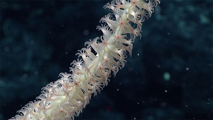
Eighteen of the submersible dives were well below 1,000 meters, reaching very close to their maximum 2,000-meter depth limits. This program resulted in the collection of numerous new species of corals and sponges and provided the first real look at some of the deep seamounts and banks in PMNM (Figure 6).

Deepwater corals and sponges found in PMNM in 2003. Image courtesy of the NOAA Office of Ocean Exploration and Research, 2015 Hohonu Moana. Download larger version (jpg, 2.8 MB).
The program also revealed, for the first time, the presence of very large and dense communities of deepwater corals and sponges living on ridges extending from these seamounts.
In 2007 and 2009, shorter follow-up cruises in the southern half of PMNM have gone up to the monuments to explore for more of these deep communities at depths below 1,000 meters. In 2011, the Pisces submersibles were used to investigate the geology of Gardner Pinnacles, which was the last time any dives were made.
Even though the deep waters of PMNM have been investigated to a greater degree than JAU, the monument is so huge that these previous dives have barely scratched the seafloor. Furthermore, no dives have ever been conducted to depths below 2,000 meters.
There is clearly much more exploring that needs to be done in both monuments for us to begin to understand what secrets they hold.