By Derek Sowers, Physical Scientist - NOAA Office of Ocean Exploration and Research

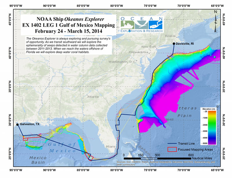
Map showing the area where the Okeanos Explorer plans to conduct operations during the first leg of the Gulf of Mexico exploration expedition. Image courtesy of NOAA Office of Ocean Exploration and Research. Download larger version (jpg, 3.8 MB).
From February 24 - March 15, 2014, the NOAA Ship Okeanos Explorer will conduct an expedition from its home port of Davisville, Rhode Island, to Galveston, Texas, while conducting seafloor and water column mapping of top-priority exploration focus areas in the Gulf of Mexico. The planned route the ship expects to travel is shown in the image above. Seafloor bathymetry and acoustic backscatter data, as well as water column acoustic backscatter data, will be collected continuously while underway. Sub-bottom stratigraphic data that provides insight into seafloor geology will also be collected daily during the expedition.
NOAA’s Okeanos Explorer systematically explores the ocean every day of every cruise to maximize public benefit from the ship’s unique capabilities. During cruise planning, transits are optimized to allow mapping of unexplored or unmapped regions. Extensive input is received from ocean science and management experts to identify unexplored regions for possible inclusion in the ship’s cruise plan.
On this expedition, transit mapping operations are planned to cover a number of identified targets along the U.S. Atlantic east coast during our transit to the Gulf of Mexico. Transit mapping operations are planned to focus on re-mapping locations where seeps were previously confirmed with underwater vehicles, or are suspected based on previous sonar data, and acquiring data in marine protected areas in the South Atlantic.

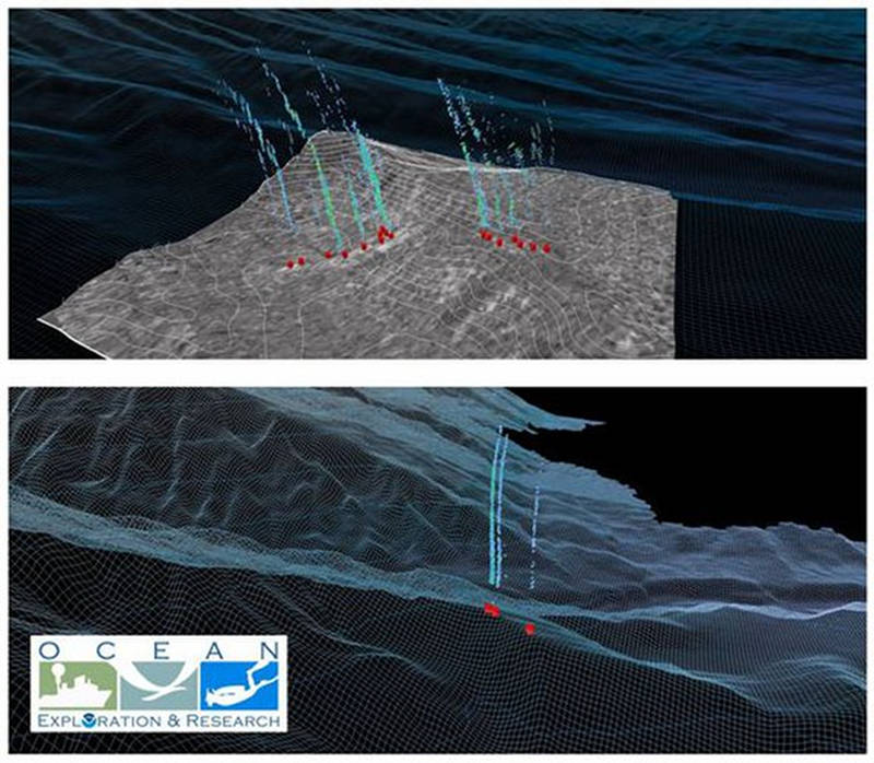
Perspective image of gaseous seeps seen during the 2012 Northeast and Mid-Atlantic Canyons Expedition, derived from water column acoustic reflectivity observations. Also shown is associated bathymetry and seafloor backscatter (location 1-top). Image courtesy of NOAA Office of Ocean Exploration and Research. Download image (jpg, 101 KB).
During the transit southward along the continental shelf offshore from Rhode Island to South Carolina, the ship will re-visit the locations of known and suspected deep water gaseous seeps previously discovered and detected in the canyons of the Atlantic continental slope by the Okeanos Explorer during the 2012 and 2013 field seasons.
These gas seeps originate from the seafloor and are natural phenomena that create plumes of bubbles that can be “seen” in sonar images. Using this sonar data, the location and orientation of gas plumes can be mapped in the water column. Re-mapping these seep areas will provide novel insights into how persistent these features may be, and to assess variability in the location or number of seeps active now versus when they were first discovered.
The ship will also explore new areas along the edge of the Blake Plateau to see if additional gas plumes can be found along a string of underwater diapirs (dome-shaped salt or gas-charged mud formations that intrude upward through more dense overlying rock).
Moving south offshore from Georgia and Florida, the Okeanos Explorer plans to map priority deep-water marine protected areas. These areas were identified by several ocean science and management experts as priorities for mapping based on their designation as Deepwater Coral Habitat Areas of Particular Concern . Deep-sea coral habitats can be highly susceptible to seafloor-disturbing human activities and are an important component of the deep-sea ecosystem. These habitats are often associated with steep and/or hard areas on the seafloor, so the bathymetry and sonar backscatter data collected by the Okeanos Explorer is a critical aid to identifying areas most likely to provide suitable places for deep-sea coral habitats to exist.

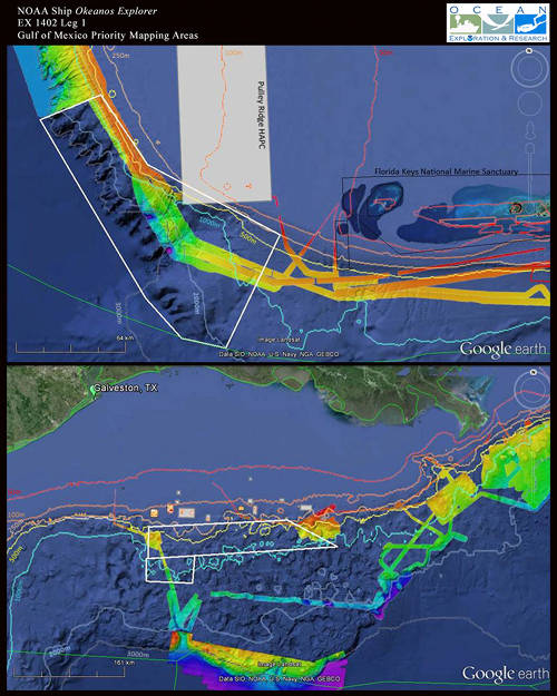
Maps showing Mapping Priority Area 1 (top) and Mapping Priority Area 2 (bottom) for Leg 1 of the expedition. The priority areas for intensive mapping survey operations are shown in the white polygons. Color-coded bathymetry previously collected by the Okeanos Explorer is shown in the background for context. Image courtesy of NOAA Office of Ocean Exploration and Research. Download larger version (jpg, 926 KB).
The Okeanos Explorer will round the Florida Keys and head west to conduct focused mapping work in the Gulf of Mexico. For Leg 1 of the expedition in the Gulf of Mexico, a priority area to conduct baseline characterization mapping is an area located off the southwest Florida escarpment, which is shown in the white polygon in the top map to the right.
This area was identified as a priority considering input from OER’s 2011 Atlantic Basin Planning Workshop, the National Marine Fisheries Service (NMFS) Southeast Fisheries Science Center, NMFS Southeast Regional Office, NMFS Office of Habitat Conservation/Deep-Sea Coral Research and Technology Program, NOAA National Ocean Service National Centers for Coastal Ocean Science, and the Gulf of Mexico Fisheries Management Council .
This region of the southwest Florida escarpment was identified as a priority area for detailed mapping work for some of the following reasons:
The seafloor and water column mapping completed on the southwest Florida escarpment during Leg 1 will help directly inform the selection of priority locations for further investigation using the Okeanos Explorer’s deep-water remotely operated vehicle (ROV) during Leg 3 of the expedition. Exploration with the ROV’s powerful lights and high-definition cameras enables scientists to gain detailed insights into the geology and biology of the seafloor. The video from the ROV can then be shared via the Internet so that millions of people can share in the excitement of ocean discovery.
Following completion of mapping operations in Map Priority Area 1 in the southwest Florida escarpment, the Okeanos Explorer will transit directly through the middle of the Gulf of Mexico en route to Map Priority Area 2 (white box in the northwest Gulf of Mexico in the bottom map shown above).
Mapping operations will focus on this region as time allows until the ship travels to port in Galveston, Texas. Completion of mapping work in Map Priority Area 2 is the primary objective of Leg 2 of the expedition, so any areas not completed in Leg 1 are planned to be mapped on the cruise immediately following.
All collected data on this expedition will be available in NOAA’s public data archives within 60-90 days of the conclusion of the cruise and can be accessed via the NOAA Ocean Exploration Data Atlas.