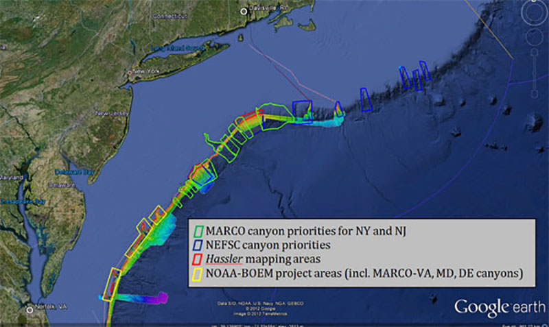
Google Earth map showing general priorities and planned coverage areas for 2012 ACUMEN operations, overlaid on existing bathymetry acquired by NOAA Ships Nancy Foster and Okeanos Explorer. Planned areas for high resolution mapping by Hassler are overlaid in red. NOAA Ship Bigelow will use a towed camera system to ground-truth areas mapped by the other ships. A complementary joint NOAA-Bureau of Ocean Energy Management (BOEM) project on the Nancy Foster is investigating canyons to the south of ACUMEN. Mid-Atlantic Regional Council on the Ocean priorities will be addressed during both the ACUMEN and NOAA-BOEM projects.  (Actual mapping and sensor coverage achieved may differ from plan due to weather conditions, technical issues, and real-time data analysis and reprioritization.)
Planned ACUMEN Operations
Image courtesy of the NOAA Office of Ocean Exploration and Research. Download image (jpg, 80 KB).
Google Earth map showing general priorities and planned coverage areas for 2012 ACUMEN operations, overlaid on existing bathymetry acquired by NOAA Ships Nancy Foster and Okeanos Explorer. Planned areas for high resolution mapping by Hassler are overlaid in red. NOAA Ship Bigelow will use a towed camera system to ground-truth areas mapped by the other ships. A complementary joint NOAA-Bureau of Ocean Energy Management (BOEM) project on the Nancy Foster is investigating canyons to the south of ACUMEN. Mid-Atlantic Regional Council on the Ocean priorities will be addressed during both the ACUMEN and NOAA-BOEM projects. (Actual mapping and sensor coverage achieved may differ from plan due to weather conditions, technical issues, and real-time data analysis and reprioritization.)
Learn more