


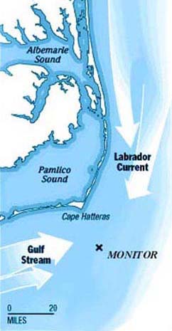
Map showing location of the Monitor National Marine Sanctuary and the prevailing currents. (Courtesy of the Daily Press, Newport News, VA) Click image for larger view.
Finding and Identifying the USS Monitor
For more than a century, the resting place of the USS Monitor remained undiscovered. There were numerous searches and occasional claims of discovery; however, no one could show proof of the Monitor’s location.
The Search
Then, in August 1973, scientists aboard Duke University’s research vessel Eastward finally located the Monitor. The survey was headed by John G. Newton, marine superintendent for the oceanographic program at the Duke Marine Laboratory.* Newton explained that the search area was determined by replotting the track of the USS Rhode Island, a paddlewheel steamer that had been towing the Monitor the night she sank. The Rhode Island’s log book recorded events and times as the two ships rounded treacherous Diamond shoals, dreaded by mariners of the time as the “Graveyard of the Atlantic.” An 1857 coast survey chart helped refine the plotting of the search area.
Indentifying the Monitor
In searching for the Monitor, the Eastward swept a 5-mile by 14-mile sector of the Atlantic. During the survey, 22 wrecks were located. The research team compared each new site with a "footprint" of Monitor characteristics. The footprint included the size and shape of the hull and armor belt, the location of and details about the turret, pilothouse and other deck features, as well as the expected sonar signature. All but one site was eventually eliminated from consideration. This object resembling the Monitor was located approximately 16 miles south-southeast of Cape Hatteras Lighthouse. The wreck was described as "lying in 220 feet of water on a hard sand and shell-strewn floor."
Although the size and shape matched the known dimensions of the Monitor, investigators were unable to quickly verify its identity. The technology of the day required them to rely on fuzzy black-and-white video images from a camera suspended on the end of a cable as the Eastward attempted to navigate back and forth over the site. A still camera on a cable snagged on the wreckage and was lost. The final week of the survey was spent studying and photographing this promising site. However, it took five months of correlating the black-and-white, closed-circuit television tapes and still images with plans and specifications before archaeologist Gordon Watts determined that the Monitor had, indeed, been found. The identification of the wreck was severely complicated by the fact that the Monitor lay upside down, which significantly altered the image that researchers had expected to find. Finally, in early March 1974, John Newton made the long-awaited announcement that the Duke survey team had confirmed the discovery of the USS Monitor.
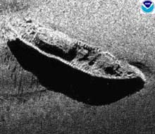
Sonar image of the Monitor recorded by the NOAA Ship Whiting, 2000 (Monitor Collection, NOAA). Click image for larger view.
Examining the Wreck
During the first week of April 1974, a second cruise to the Monitor site produced detailed photographic and television tape records of the site. This project deployed the ultra-sophisticated research vessel Alcoa Seaprobe, which was specifically designed for deep-ocean search and recovery operations. The Seaprobe’s dynamic positioning capability, which permitted it to hover over the Monitor without the use of anchors, greatly facilitated operations. Once the Seaprobe located the wreck of the Monitor, scientists began a systematic examination of the wreck site with the ship’s search pod, a metal frame containing side- and forward-looking sonar, television cameras with floodlights, and two deep-sea 35mm cameras with strobe lights.
Battling heavy seas and strong currents, the Seaprobe survey collected more than 1,200 quality photographs and several hours of videotape. The U.S. Navy’s Naval Intelligence Support Center used many of these images to prepare a complete photomosaic of the wreck. The photomosaic convinced the last of the doubters that the Monitor had, indeed, been found. Today, this photomosaic remains one of the most important resources for research on the Monitor.
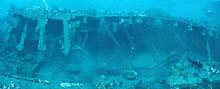
Photomosaic of the Monitor's lower hull showing the port armor belt. (Monitor Collection, NOAA) Click image for larger view.
Designation as a National Marine Sanctuary and National Historic Landmark
The discovery of the USS Monitor was announced jointly by Duke University and the North Carolina Department of Archives and History on March 7, 1974. A question was immediately posed: What should be done with the Monitor, one of the most important objects--both symbolically and actually--in American history?
After many discussions among a wide variety of federal, state and local organizations, as well as historians and the public, the Governor of North Carolina nominated the wreck of the Monitor for National Marine Sanctuary status on Septemper 26, 1974. To further the cause of protecting this valuable historic resource, the U.S. Secretary of the Interior listed the USS Monitor on the National Register of Historic Places on October 11, 1974.
On January 30, 1975, the Secretary of Commerce made history when he designated the remains of the USS Monitor and a column of water one nautical mi in diameter surrounding the vessel as the first U.S. national marine sanctuary.
On March 9, 1987, the 125th anniversary of the battle between the USS Monitor and the CSS Virginia, the U.S. Secretary of the Interior, Donald Hodel, designated the USS Monitor a National Historic Landmark.
*Joining John G. Newton as co-investigators were Dr. Harold “Doc” Edgerton of the Massachusetts Institute of Technology, inventor of the strobe light and a pioneer in scanning sonar technology; Gordon P. Watts, Jr., then underwater archaeologist with the North Carolina Department of Cultural Resources; and Dr. Robert E. Sheridan, then a geologist from the University of Delaware.
Support for
searching for the Monitor came from the National Geographic
Society, the National Science Foundation, the North Carolina Department
of Cultural Resources, and the U.S. Army Reserve.
Sign up for the Ocean Explorer E-mail Update List.