
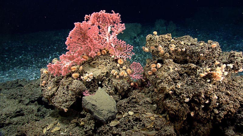
Corals, including cup corals and bubblegum corals, reside on a hard substrate near the edge of a mussel bed. Image courtesy of NOAA Office of Ocean Exploration and Research, 2013 Northeast U.S. Canyons Expedition. Download larger version (jpg, 1 MB).
During this expedition, explorers will investigate underwater canyons about 50 miles off the coast of North Carolina. The expedition will expand on knowledge gained from previous canyons-focused expeditions conducted in more northern regions of the U.S. Atlantic coast.
The purpose of this expedition is to investigate and characterize the biological and geological features in this area, in particular deep-sea coral habitats and cold seeps. To date, little is known about this deep-slope environment on the outer continental shelf of the U.S., but it is of great importance due to its value to offshore fishing, renewable energy, tourism, and coastal and offshore hazards.
Underwater canyons are striking structures that cut into the continental margin, dropping from hundreds to thousands of meters, thereby connecting the upper continental shelf to the deep sea. They are geographically and biologically complex features where organic matter and nutrient-rich sediment are often concentrated. These conditions can support a high diversity of biological habitats, including deep-sea coral habitats and habitats of commercially important fish. However, the full extent of these habitats, their distribution, and community structure is still unknown.
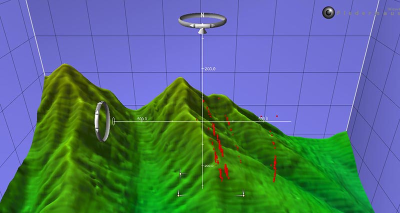
Interactive scene file of cold seeps within a three dimensional data visualization system called Fledermaus. The series of red dots rising from the sea floor are the bubbles from methane seeps detected by the multibeam sonar during the Northeast U.S. Canyon Expedition 2013. Image courtesy of NOAA Office of Ocean Exploration and Research. Download larger version (jpg, 337 KB).
Hydrocarbon seepage also occurs around canyons, and can cause submarine landslides on the continental slope, which have the potential to generate tsunamis. During previous expeditions in Atlantic canyon regions, numerous gaseous seeps emitting plumes of bubbles from the seafloor were discovered. These gaseous seeps can support unique communities of organisms that scientists are just beginning to understand.
Increasing baseline knowledge of underwater canyons and discovering new habitats will ultimately benefit the management and preservation of these remarkable ecosystems. The need to learn more about this relatively undisturbed environment is becoming more urgent, particularly as fishing practices, mining activities, and hydrocarbon exploration extend into the deep ocean.
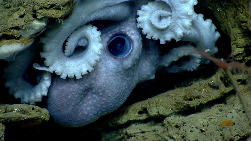
An octopus hides in the rocks in Welker Canyon. Image courtesy of NOAA Office of Ocean Exploration and Research, 2013 Northeast U.S. Canyons Expedition. Download larger version (jpg, 681 KB).
From August 24 to September 7, 2016, a team of explorers on NOAA Ship Pisces will investigate the diversity and distribution of deep-sea habitats along underwater canyons about 50 miles off the coast of North Carolina. Specifically, the expedition will target deep-sea canyons Keller, Hatteras, and Pamlico, where both cold seeps and deep-sea coral communities are likely to occur.
Scientists will collect information to further our understanding of the diverse and dynamic biology of the region. Geological features will also be investigated, including where potential landslides may have occurred or could occur in the future.
Using multibeam sonar technology, the team will map the seafloor along the edge of the continental shelf of the U.S. East Coast, where the relatively shallow coastal shelf seafloor dramatically slopes down to the deep sea, forming complex and rugged ocean canyons. The ship will traverse the heads of these canyons and map along the edge of the continental shelf to add to existing high resolution multibeam sonar maps of areas further north. Photographs of the underwater area will help to further understand the canyon landscape and coral habitats; measurements in the water column can detect bubble plumes and help find cold seeps; and sediment samples collected on the seafloor will help to further understand this potentially nutrient-rich environment.
Many canyons within this region remain completely unexplored. Although considerable investigations of canyons along the U.S. East Coast were conducted in the 1960s-80s, relatively little work has been conducted more recently using the latest technologies.
Scientists will use the following exploration tools for this expedition while aboard NOAA Ship Pisces:
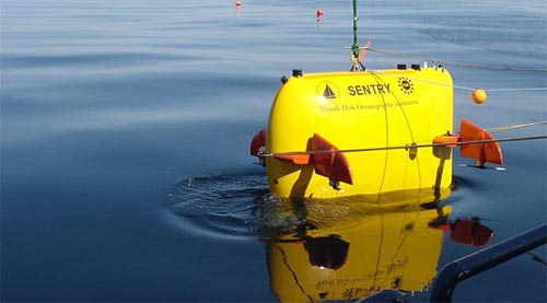
The autonomous underwater vehicle Sentry is designed to dive as deep as 6,000 meters (19,685 feet). It is powered by more than 1,000 lithium-ion batteries—similar to those used in laptop computers, though adapted for extreme pressures—which allow it to dive up to 20 hours Image courtesy of Chris German, Woods Hole Oceanographic Institution. Download larger version (jpg, 164 KB).
Autonomous underwater vehicles (AUVs) are unoccupied underwater robots that operate independently of humans (similar to the Curiosity rover NASA uses on Mars). AUVs can glide from the sea surface to ocean depths and back. Others can stop and hover in one spot.
AUVs are self-guiding and self-powered vehicles with no physical connection to a ship, so they can move fast and far, and they are relatively safe from bad weather once in the water. AUVs have the ability to reach shallower water than boats and can reach deeper water than human divers or tethered vehicles.
Different sensors can be attached to AUVs depending on what measurement scientists are looking to collect; for example, AUVs can create maps of the ocean floor, record environmental information, identify hazards to navigation, or explore geologic formations. AUVs are often less expensive to operate than research vessels, and they can conduct similar operations and activities. All of this makes AUVs an attractive option for ocean research.
On this expedition, the team will use AUV Sentry to survey canyon areas and slope habitats off the coast of North Carolina. Sentry will conduct dives at depths of 500-2500 meters, collecting a variety of water column, seafloor data, and still images of geological features as explorers search for deep-sea coral habitats and cold seeps.
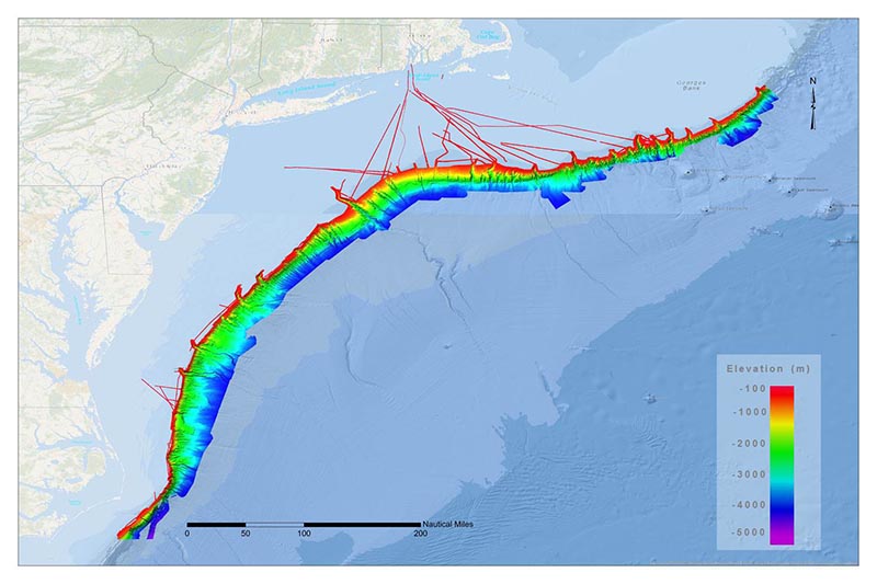
From 2011-2014, NOAA and partners mapped all or part of every submarine canyon between the Exclusive Economic Zone from the U.S.-Canada border to North Carolina, totaling more than 34,000 square miles of seafloor. This map includes high-resolution bathymetry acquired by NOAA Ships Okeanos Explorer, Ferdinand R. Hassler, Nancy Foster, and Ronald H. Brown. Download larger version (jpg, 541 KB).
A high-resolution multibeam sonar system will be mounted on the AUV as well as the ship to map the seafloor in areas where data are missing or incomplete. Active sonar devices use sound and returning echo times to measure distance to the object that is being studied. The resulting maps will show depths of landforms below sea level and help visualize the canyons. This tool will also identify and characterize biological resources in the water column. This information will help explorers determine which locations to investigate further.
CTD stands for ‘conductivity, temperature, and depth,’ and refers to a package of electronic instruments that measure these properties in the water. A CTD's primary function is to detect how the conductivity (how well a liquid conducts electricity) and temperature of water changes with depth. Conductivity is directly related to salinity, which is the concentration of salt and other inorganic compounds in seawater. Salinity is one of the most basic measurements used by ocean scientists. When combined with information about temperature, salinity measurements can be used to determine seawater density, which is a primary driving force for major ocean currents.
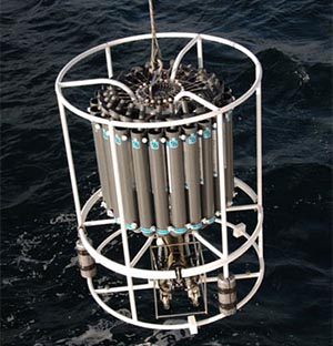
A CTD is lowered into the water to measure the salinity, temperature, depth and concentration of particles in the water column. Image courtesy of NOAA Office of Ocean Exploration and Research, INDEX-SATAL 2010. Download larger version (jpg, 541 KB).
CTDs are often attached to a much larger metal frame called a rosette, which may hold water-sampling bottles that are used to collect water at different depths, as well as other sensors that can measure additional physical or chemical properties. CTDs can provide profiles of chemical and physical parameters through the entire water column. By analyzing these factors, scientists can learn about certain biological processes, such as the growth of algae. Sudden changes, or “anomalies,” in one or more of the properties being measured may alert scientists to something unusual, such as bubble plumes indicating cold seeps. Knowledge obtained from CTD devices can, in turn, lead to a better understanding of things such as where species occur and how they are distributed in the ocean.