By: Ashlee Henig,
Donna Blackman - Scripps Institution of Oceanography, University of California — San Diego
and Christopher German - Woods Hole Oceanographic Institution
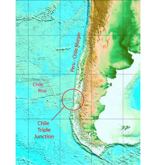
The Chile margin is composed of submerged continental shelf extending from the west coast of Chile into the Pacific Ocean. It is is as geologically diverse as it is long. Extending the entire length of South America, the margin is punctuated by the deep Peru-Chile trench where the Cocos, Nazca, and Antarctic plates are converging with and sinking beneath the South American plate. This type of plate boundary is called a subduction zone, and this one is intersected at 46°S by the Chile Rise, a spreading center where the Nazca and Antarctic plates separate and new oceanic crust forms (figure 1).

Figure 1. This map of the Southeast Pacific Ocean and South American continent shows the Chile Rise spreading center, the Peru-Chile margin, and the location of the Chile triple junction. Image courtesy of INSPIRE: Chile Margin 2010. Download image (jpg, 81 KB).
The age of the subducting crust becomes progressively younger from north to south along the eastern edge of the Nazca plate, until the newly-formed crust at the actively spreading Chile Rise enters the trench. This location is termed a triple junction since three different tectonic plates meet there.
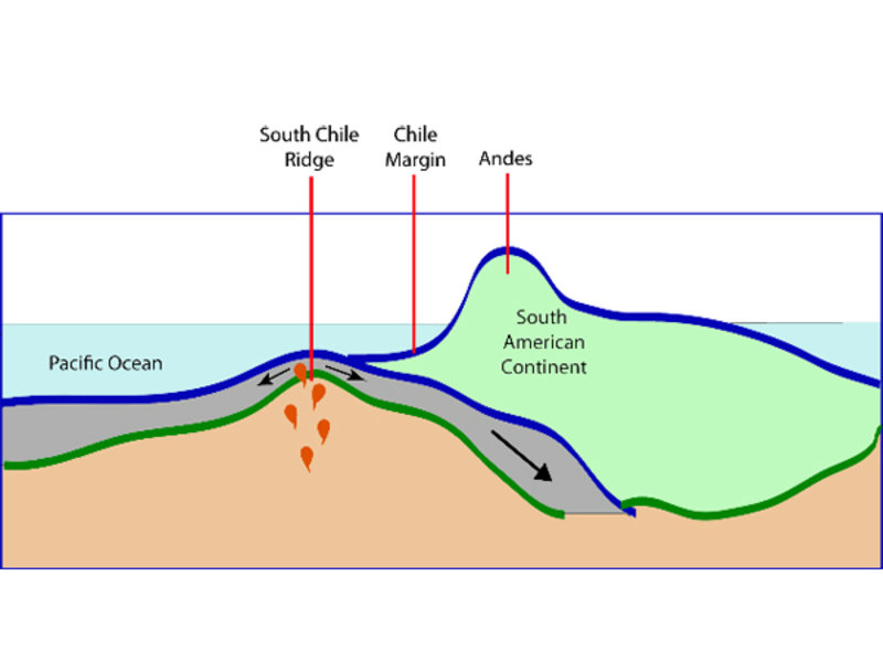
The Chile triple junction (CTJ) is the only modern site on Earth where an actively spreading mid-ocean ridge crest is being swallowed by a subduction zone at a continental margin (figure 2). This is a particularly interesting area to study because we can observe two types of plate boundaries and their processes in very close proximity. The Chile Rise continues to spread as it is thrust beneath the continental margin of South America. Because of the angle between the trench and subducting ridge segment, one flank (or side) of the ridge is underneath the continental margin, while the other flank is exposed on the seafloor. Also because of the oblique subduction, the age of subducting crust varies from 0 Million years (Myr) at the triple junction to 25 Myr 900 kilometers/km (560 miles) north of the CTJ.

Figure 2. A schematic cross section through the spreading center, subduction zone, and South American continent. Image courtesy of INSPIRE: Chile Margin 2010. Download image (jpg, 42 KB).
In 1960, the Chilean subduction zone was host to the largest earthquake ever recorded, a magnitude 9.8 quake that ruptured over a distance of 1,000 km (621 miles) along the Chile margin. This earthquake triggered a powerful tsunami that caused damage to coastal areas throughout the Pacific Ocean as far away as Japan. The earthquake rupture would have continued farther south along the subduction zone and possibly been even more devastating had it not encountered the warm and ductile (malleable, pliant) crust of the subducting Chile Rise at the triple junction. This event is an excellent example of the powerful tectonic forces contained within the subduction zone at the Chile margin area.
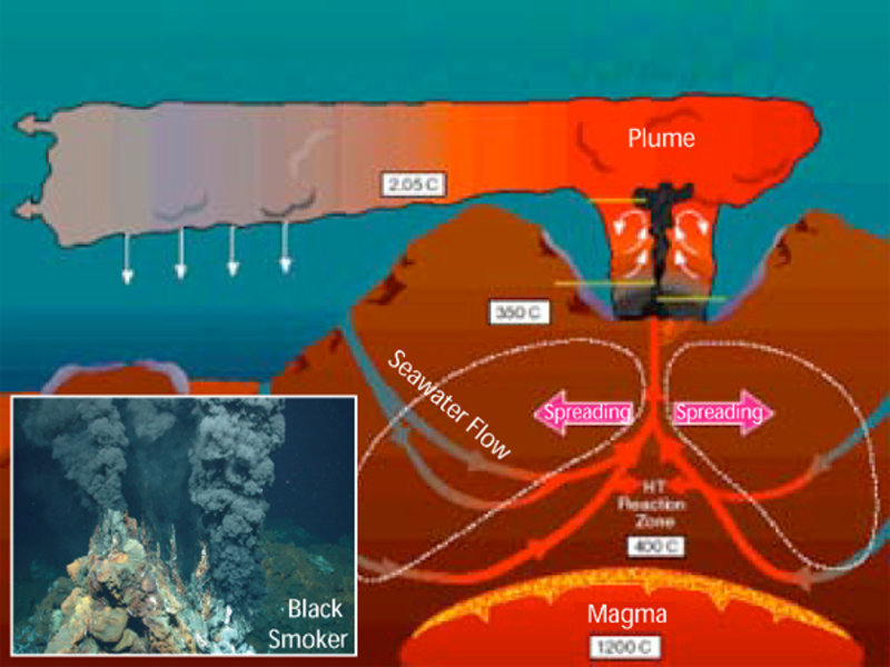
The unique triple junction geometry is conducive to the formation of several different types of hydrothermal venting. Hydrothermal venting occurs when seawater penetrates the crust or sediments near the axis of an oceanic spreading center; is heated by the underlying magma (molten rock) or a chemical reaction; and returns to the seafloor as hot (or warm), mineral-rich water (figure 3). Since the Chile Rise is spreading at an intermediate rate of about 60 millimeters/yr (2.4 inches/yr), the amount of magma beneath the ridge is enough that high-temperature "black smoker" type hydrothermal systems with mineral-rich chimneys (figure 3, inset) are likely to be found approximately every 100 km (62 miles) on the ridge near the triple junction.

Figure 3. These bathymodiolid mussels and vestimentiferan tube worms were collected from a methane seep off the coast of Costa Rica. They provide habitat for many associated species, including the gastropods seen in this picture. Many large limpets live on the tubes and shells, where they graze on bacteria and other microbes. Image courtesy of Haase et al., 2005. Download image (jpg, 96 KB).
Also, because the ridge continues to spread beneath the continental margin, seawater in the sediments of the overlying plate could potentially be heated, leading to a cooler, more diffuse hydrothermal system on the landward side of the triple junction.
Locating hydrothermal systems is a key aspect of the INSPIRE: Chile Margin 2010 cruise, both for their geologic implications and because they are reducing environments that provide fundamental clues to biogeochemical exchanges in the deep sea.
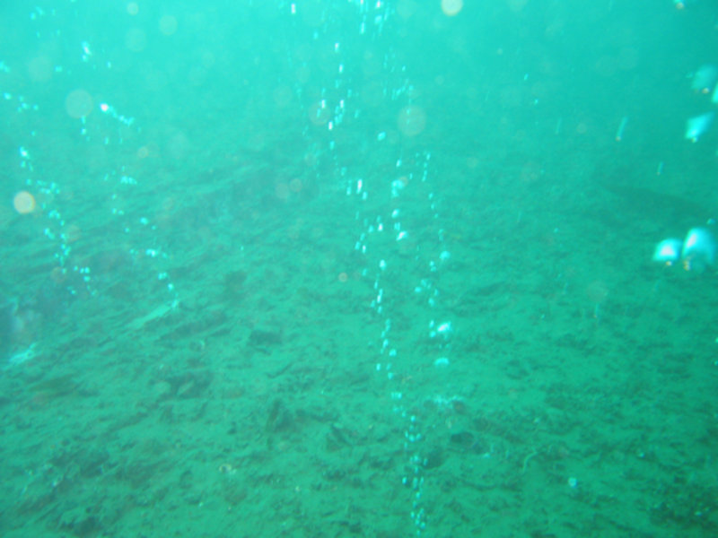
The geology of the Chile margin also makes the area a prime location for the formation of methane seeps, another primary target for cruise research. The intermediate water depth — about 800 to 1000 meters (2,652 to 3281 feet) — of the continental margin has the ideal temperature and pressure conditions for the formation of methane hydrates, or methane locked inside ice crystals. Evidence of its occurrence can be seen in seismic profiles of the sediments on the continental margin through a distinct reflection of energy called the bottom-simulating reflector (BSR). Because of instabilities on the continental shelf associated with large thermal gradients, caused by a subducting slab or a change in sea level, methane hydrates can melt and methane can seep out of the sediments forming another type of reducing environment interesting to cruise researchers (figure 4).

Figure 4. Methane gas bubbling up from sediments at a seep area. Image courtesy of David Valentine. Download image (jpg, 82 KB).
Our mapping and sampling program should allow scientists to observe hydrothermal vents, methane seeps, and small structural detail of the seafloor to better characterize the geology and tectonic forces of this unique area where a subducting spreading ridge underlies a continental margin.