

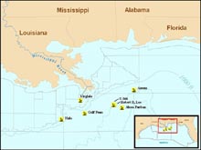
The WWII Gulf of Mexico Shipwreck Survey Expedition will investigate the long-term effect of manmade structures on the deep sea, as well as the effect of the environment on those structures. This map shows the locations of vessels identified by this study. Click image for larger view.
WWII Gulf of Mexico Shipwreck Survey Expedition 2004
July 29 - August 15, 2004
Dan Warren and Rob Church
C & C Technologies, Inc.
Throughout the ages, humans have been fascinated by the sea. In earliest times, we wondered: what creatures inhabit these deep, dark waters? And, later, we asked: what has become of the many ships that have met their end at sea and now lie beneath the waves?
Over time, our questioning has evolved. Today, we want to know the specifics, such as the the long-term effect of manmade structures on the deep sea, and, conversely, the effect of the environment on those structures. The 2004 WWII Gulf of Mexico Shipwreck Survey Expedition aims to find out. A team of world-renowned scientists will venture into the deep waters of the Gulf of Mexico on an 18-day research mission to conduct just such an investigation. The multidisciplinary group, overseen by the Interior Department’s Minerals Management Service (MMS), will depart July 29 from Port Fourchon, LA aboard the NOAA-contracted research and exploration vessel HOS Dominator.
The MMS, in partnership with the NOAA's Office of Ocean Exploration (OE), under the auspices of the National Oceanographic Partnership Program, awarded a contract to C & C Technologies, Inc. to conduct the research. MMS is providing $350,000 toward research costs and NOAA OE is funding the ship time, a deep-submergence remotely operated vehicle (ROV), and personnel for both, all provided by Sonsub, Inc. of Houston.
The study has two separate but equally important objectives: an archaeological/historical objective and a biological objective. The archaeological aim is to document the wreck sites being investigated as historic properties with significance to American history. The biological component will approach the question, “Do manmade structures, such as shipwrecks, function as artificial reefs in deep water?"
Team members believe the joint effort will yield excellent results.
“This field study is an exciting opportunity for all participants,” concluded John McDonough, project coordinator at NOAA OE. “We believe this joint effort will expand our knowledge in areas such as the management and preservation of historic shipwrecks and other submerged cultural resources. At the same time, this expedition uses ocean exploration and interdisciplinary oceanographic research to capture the public’s imagination with the message that we have a great deal to learn about Earth’s oceans and their effect on our lives.”
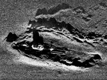
A side-scan sonar image of the German U-boat U-166, collected by the HUGIN 3000 AUV in 2001. Click image for larger view and image credit.
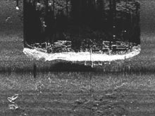
A side-scan sonar image of the passenger freighter Robert E. Lee, collected by the HUGIN 3000 AUV in 2001. Click image for larger view and image credit.
In the Gulf of Mexico, we have accepted that the conversion of offshore oil and gas structures into artificial reefs on the continental shelf benefits the fisheries. Regarding the deeper waters beyond the shelf, however, we need additional information about the significance of a deep-sea artificial reef effect.
Thanks to history, the Gulf is perfect for this work.
“The Gulf is the ideal laboratory for this study, because of the number of steel-hulled ships that were casualties of World War II,” explained Rob Church, C & C Technologies' project manager for the study. The Gulf represents one of the greatest concentrations of Allied vessels lost to German U-boats (U-166 Exploration 2003) anywhere in the world, with 56 ships sunk in 1942 and early 1943.
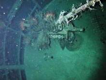
A close-up of the U-166 "wintergarten," with its 20mm anti-aircraft gun. Click image for larger view and image credit.
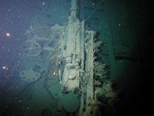
A close-up of the U-166 37mm main deck gun. Click image for larger view and image credit.
According to MMS marine archaeologist Dr. Jack Irion, “Seven of these vessels, located during the oil and gas surveys that are required by MMS, were selected for this study, because they represent a range of depths [from 280 ft to 6,500 ft] and carried a variety of cargoes.
The depth range represents different ecological niches and most of the vessels were sunk within a few months of one another. "The wrecks offer a unique opportunity to study the artificial reef effect in differing depths after a period of 60 years,” said Dr. Irion.
Biologists will study the environment at each site to determine the impact -- called the artificial reef effect -- each shipwreck has on the sea-floor biology. They will look at how microbes have modified the sediments in the immediate vicinity of the wreck sites as compared to sediments farther from the sites. The scientists hope to determine how tiny microbes cause the slow disintegration of steel structures at great depths, how the cargoes the ships carried might affect the rate of disintegration, and how the biological communities might change as the ships deteriorate. In the end, the scientists hope to learn how manmade structures on the sea floor might act to enhance or detract from their environment.
In addition to the biological studies, team members will document the vessels and study their historic merits for potential nomination to the National Register of Historic Places.
The prime contractor for this study, C & C Technologies, Inc. of Lafayette, LA, is a leader in the field of marine geophysical surveys. This group has discovered many of the wrecks included in this study. C & C Technologies will be joined by a team of world-renowned scientists in the fields of microbiology and marine invertebrate and vertebrate zoology. They include Dr. Roy Cullimore of Droycon Bioconcepts, Inc. of Regina, Saskatchewan, Canada, whose previous research includes microbial analyses of the RMS Titanic, the DKM Bismarck, and the HMHS Britannic. Dr. Cullimore is joined by Dr. William Schroeder, senior marine scientist at the Dauphin Island Sea Lab and University of Alabama professor; Dr. Thomas Shirley, professor of invertebrate biology at the University of Alaska, Fairbanks; and Dr. William Patterson, assistant professor of marine vertebrate zoology at the University of West Florida.
Dr. Annalies Corbin, executive director of the Partnering Archaeology with Science and Technology (PAST) Foundation and assistant professor of nautical archaeology at East Carolina University, will oversee the study's outreach and education component. A full curriculum, based on each mission component, will be available to all educational institutions in an easy-to-download format via the PAST Foundation Web site. Included in the outreach will be an interactive project Web site, spearheaded by Andrew Hall, who has been involved with developing several nautical archaeology project Web sites, and a documentary to be produced by award-winning filmmaker Dr. Dennis Aig, professor of media and theatre arts at Montana State University, Bozeman. Daily text and ROV still photos will be provided, and two- to three-minute streaming video pieces will be offered every other day.
The Minerals Management Service is the federal agency in the U.S. Department of the Interior that manages the nation’s oil, natural gas, and other mineral resources on the outer continental shelf in federal offshore waters. The agency also collects, accounts for, and disburses mineral revenues from federal and American Indian lands. MMS disbursed more than $8 billion in FY 2003 and more than $135 billion since the agency was created in 1982. Nearly $1 billion from those revenues go into the Land and Water Conservation Fund annually for the acquisition and development of state and federal park and recreation lands.
A part of the U.S. Department of Commerce, NOAA is dedicated to enhancing economic security and national safety through the prediction and research of weather and climate-related events and providing environmental stewardship of our nation’s coastal and marine resources.