back banner
back button
spacer
ocean explorer home pageNOAA home page

MR1 sidescan sonar


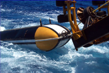
The MR1 towed long-range sidescan sonar system, which will be used to map the submarine volcanoes in the Marianas arc. Image courtesy of Hawaii Mapping Research Group. For more information about the MR1 system check out the web page at http://imina.soest.hawaii.edu/HMRG/


Related Links

Submarine Ring of Fire: Seafloor Mapping - Mariana Arc, 2003

Submarine Ring of Fire: Explorer Ridge, 2002


E-mail Updates | User Survey | Report Error On This Page | Site Index | Contact Us
Revised July 11, 2005 by the Ocean Explorer Webmaster
National Oceanic and Atmospheric Administration | U.S. Department of Commerce
NOAA Logo Commerce Logo
http://oceanexplorer.noaa.gov/explorations/03fire/background/mapping/media/mr1.html