


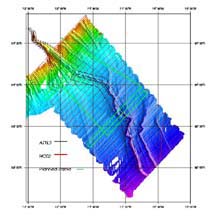
The projected trackline for our last few days of surveying. The green lines are the ones that we are hoping to complete before the end of the Hudson Canyon exploration. The red lines represent the tracklines that we followed before Hurricane Gustav made us depart the survey area. Click image for larger view.
Off and Running...Again
September 12, 2002
Lisa M. Weiss, Watershed Coordinator
Jacques Cousteau National Estuarine Research Reserve
So, we weathered Hurricane Gustav. The winds were strong and the temperatures dropped, but we held anchor overnight and were ready to resume our activities this morning. As a high pressure system made its way into the area to replace the low caused by the hurricane, the seas calmed and the day began as a beautiful, but chilly morning. We said goodbye to the sight of land, and to our cellular phone and television connections. At 0800 we "broke anchor."
We pulled in the 360 feet of anchor chain that we had let out to hold us in place in New York harbor. While the chain was lifted, we sprayed it with freshwater as the wildcat fed it into the anchor chain box under the first deck. Once the anchor broke loose from the bottom and came to the surface, it was sprayed off as well with one of the fire fighting hoses, and then secured to the side of the ship. We were off to the survey area again, 150 miles offshore.
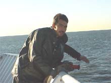
Chris, a member of the deck department poised and ready to spray off the anchor as it was lifted from its position. After holding us through the strong winds of Hurricane Gustav, the anchor was embedded deep into the seafloor and was in desperate need of a good rinsing. Click image for larger view.
With only a few days remaining before we are due into port, our next few days are carefully planned to use the time wisely. We decided to return to the top of the horizontal tracklines and begin a vertical dip-line that I referred to in the September 11 log. We will continue moving horizontally until we intersect trackline 32. Then we will begin re-surveying areas that were not well covered earlier in the trip. We will resume horizontal tracklines, set apart at wider distances, and then move back up vertically to the top of the priority mapping area, completing a second dip-line. Once at the top of the priority area, we will map a patch in the top of the southwest corner of the priority box area. At this point we will be 107 miles from our berth in New York City and will have just enough time to reach our destination by 1400 Sunday morning.
Sign up for the Ocean Explorer E-mail Update List.