


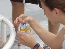
Laura filling sample jars with the water samples that were collected at various depths up the water column. Click image for larger view.
And we're off!
August 31, 2002
Randy L. Ramey, Survey Technician
NOAA Ship Ronald H. Brown
Our scientific data collection began yesterday. The day began with a CTD cast to collect water samples, with the hopes of identifying methane gas maximums. This day also marked the beginning of our SeaBeam mapping, and as of dinner last night (5:30pm) we have finished about half of one of our sweeps along one of our tracklines...only 47 and a half more to go!
At 0800 we convened at the staging area of the ship, ready and waiting anxiously for the CTD rosette to be cast into the water. In order to make this water collection, the ship had to be held in a stationary position on the spot that we had designated as our sample location. This was accomplished by the navigational officer, up in the bridge, as explained in the Aug 29 log. Working with the exact GPS point, the ship's officers are able to, more or less, hold us steady.
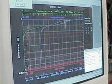
Monitor from which scientists are able to trigger the Niskin bottles to "fire," hence collecting the water samples. Click image for expanded caption and larger view.
As the rosette dropped through the water column, we were able to monitor the depth to which it was dropping, the speed at which it was dropping, and the temperature and salinity values throughout the water column. We had a relative idea of the depth of the water column, but we made sure that as we got close to that point, we slowed the lowering speed and monitored the depth carefully. There was no camera attached to tell us that we were getting close to the bottom, and we certainly don't want to hit the bottom with the rosette ... all factors leading to a nervous few minutes before water samples were collected from this "bottom location."
Laura had predetermined where she wanted to take samples. So as the rosette began its ascent, she was able to trigger a Niskin bottle on the CTD to close, thus capturing the water from that specific depth. A computer monitor back inside the ship indicated the depth where the bottles were triggered, so Laura could monitor her sampling as the bottle were making their ascent.
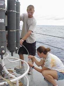
Laura and Kyle work together to remove the collected water samples from the Niskin bottles after they are brought back onto the ship. This particular CTD cast went to about 3500 meters, where the water temperature is about 2 degrees Celsius! Click image for larger view.
When the CTD rosette system was back on the ship, Laura and Kyle worked to transfer the samples from the Niskin bottles into glass sample bottles, which Laura will then bring back to SUNY Stony Brook. The water was allowed to overfill the bottle, ensuring that the bottle is washed carefully with the water sample. Laura then added a chemical—sodium hydroxide (NaOH)—which acted to kill any of the living organisms that were found in the water. She does this because she doesn't want anything other than the water sample, collected at specified depths, to create methane gas in the sample. Upon adding the NaOH, a white precipitate—calcium hydroxide (CaOH)—formed from the reaction between the NaOH and the calcium in the seawater. The result was the formation of snow-like crystals in Laura's sample bottle.
These water column samples are being collected because Mary Scranton at SUNY Stony Brook is interested in finding methane maxima in the water, which would indicate methane seeps from the seafloor. The larger scope of this research is the potential for finding novel organisms at these potential methane vents, and possibly locating places in the seafloor that are home to large deposits of methane hydrates. These are methane gas molecules locked into a ice-like matrix.
So we continue on with the seafloor mapping, or, as it is referred to on the ship, mowing the lawn. Along our trackline is one of NOAA's data buoys. Through the NOAA Data Buoy Web site, you can find out the temperature, wind speed and direction, and other water and weather conditions for the exact area that we should be mapping today. Check it out, and see how our offshore weather compares to yours!
We have one day down, and about 13 or 14 more to go. Then maybe, we will finally have a well-made image of what the seafloor looks like in this area that we know as the Hudson Canyon.
Sign up for the Ocean Explorer E-mail Update List.