


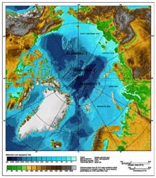
International bathymetric chart of the Arctic Ocean, with locations of proposed expeditions of the International Survey of Arctic Ridges and Basins. Click image for larger view.
Mission Plan - Arctic Ocean Exploration
International Exploration of the Canada Basin
Kathy Crane
Mission Coordinator, Arctic Expedition
Program Manager, NOAA Arctic Research Group
Background
Deep within the Arctic Ocean lies the isolated Canada Basin. It is largely unexplored due to the thickness of the ice, which covers the basin year-round. Little is known about this area other than that which the human eye can detect from a surface ship or which is picked up from a satellite sensor. Limited efforts have been made to provide longer-term data from such facilities as the drifting ice island T-3 and periodic Russian North Pole ice camps. Some data collected for national defense purposes are now available, and are providing a better picture of the bathymetry (bottom features) and circulation patterns of the Arctic Ocean. Yet the deeper portions of this northern ocean, and areas far from land-based facilities, remain mysterious.
Exploration Approach
During the summer of 2002, the National Oceanic and Atmospheric Administration (NOAA) and its domestic and international partners will undertake an expedition in the Canada Basin. Because the biota in this deep basin have been geologically isolated from the deep waters of the rest of the world's oceans for tens of millions of years, there is a high likelihood that relic forms of life, or new "theaters" of evolution, may be found. This type of region can be called an “Isolated Eden.”
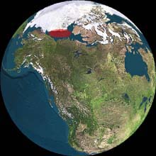
Globe showing the Arctic Research Area. The red oval indicates the general location of the research area just north of Canada. Alaska is shown to the far left in the image. Click image for larger view.
NOAA also hopes to search for evidence of massive slope failure along the margins of the basin. Slope failure may be linked to the de-gassing of methane from below. To understand the Arctic’s contribution of greenhouse gases into the environment, sources from all around the Arctic Rim must be mapped. The sources, though difficult to find, are thought to be enormous in quantity. Oil and gas fields lie under the Russian, U.S., Canadian and Norwegian Arctic. Methane, tied up in gas hydrates, is also thought to rim the Arctic. By locating new sources of methane into the water column, we may help to quantify the Arctic-wide exchange rate of greenhouse gases, which control the changing climate on Earth.
Together with our Canadian and Japanese colleagues, we also hope to map the dynamics of the Beaufort Gyre for the first time. A gyre is a huge, rotating water current that moves massive amounts of surface water in circles around each of the large ocean basins. The movements of the Beaufort Grye are thought to control the variability of fresh- and saltwater in the Arctic.
Technology and Science Plan
The expedition will depart from the small village of Kugluktuk, Canada, with 50 scientists from the United States, Canada, Japan and China. We will work aboard the Canadian Coast Guard Ship (CCGS) Louis S. St-Laurent ![]() , a large, high-performance Canadian icebreaker. During the course of the expedition, the NOAA-funded team will also work on the Canadian icebreaker CCGS Sir Wilfrid Laurier
, a large, high-performance Canadian icebreaker. During the course of the expedition, the NOAA-funded team will also work on the Canadian icebreaker CCGS Sir Wilfrid Laurier ![]() and on the Japanese ice-strengthened vessel R/V Mirai.
and on the Japanese ice-strengthened vessel R/V Mirai.
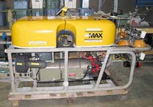
This is a side view of the Global Explorer, an ROV developed by Deep Sea Systems International, Inc., will be an integral part of the Arctic Expedition. Scientists will use the ROV at depths of up to 3000m to explore both the pelagic and benthic environments of the Canada Basin. Click image for larger view.
An advanced remotely operated vehicle (ROV) has been developed to work under the ice at great depth, combining flexibility, portability and versatility in sampling and imaging operations. As this is the first attempt to use this state-of-the-art equipment, we will learn a tremendous amount about under-ice engineering and operations. These operations will be complemented by more traditional wire-line sampling of the remote sea floor and water column. With the ROV, we hope to search for unknown forms of life, sample the water column to help determine the great transport pathways of this unexplored sea, and bring back samples of the lifeforms, water and sediments.
Scientists will conduct an extensive and locally intensive survey of the ice cover and its variation in thickness over space and time, and of the biology and geochemistry of the seabed and near-bottom water column. They will characterize the geochemistry of surficial sediments, and of cores where possible; measure temperature, salinity, nutrients and conservative tracers over the full depth of the water column; catalog macrobiota (larger creatures) living on or near the sea floor, and conduct initial characterizations of benthic (bottom-dwelling) and pelagic (deep-water) species diversity; and correlate the ecological structure of major benthic and pelagic communities with oceanic and geophysical features. They will also obtain sediment cores to help reconstruct climate history and paleo-ecological events in the Arctic Ocean.
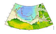
The red line indicates the projected cruise path for the CCGS Louis St. Laurier. The blue dots with circles around them depict the areas projected to include ROV operations. Click image for larger view.
The science team also hopes to contribute to the search for new products from the sea. Scientists will collect smaller biota and microbial organisms for chemical, biological and genetic analysis; investigate the growth and culture requirements of recovered bacterial species; and screen recovered bacterial species for chemical, biological and enzymatic activity.
Education and Outreach
Educators, media specialists and data managers will be involved from the beginning of the Canada Basin expedition. Working with divers from the Canadian Department of Oceans and Fisheries, a team of under-ice divers and photographers from the National Geographic Magazine will photograph, videotape, and sample the creatures in this deep-sea ecosystem. Data management will be coordinated with NOAA's National Oceanographic Data Center (NODC), National Climatic Data Center (NCDC), National Geophysical Data Center (NGDC), and National Snow and Ice Data Center, along with universities and other relevant organizations, such as the Arctic Council's Arctic Monitoring and Assessment Program and Conservation of Arctic Flora and Fauna Program.
Partners
NOAA's partners in this expedition include the University of Alaska, the University of Washington, the Smithsonian Institution, Harbor Branch Oceanographic Institute, the Monterey Bay Aquarium Research Institute (MBARI), and institutes in China, Canada and Japan.
Sign up for the Ocean Explorer E-mail Update List.